Uncategorised

Turbary stones

Holme Moss conjures up different images for people: for some it’s an iconic bike ride climb; for others a treacherous moorland road where to venture in the winter is to court danger. But for the residents of the Graveship of Holme the Moss (and ‘moss’ is a local term for a peat-bog) was their source of fuel, and peat was also used for other purposes, eg roofing.

The Graveship of Holme was (in fact still is) a collection of townships around Holmfirth in West Yorkshire. Its origins have nothing to do with burying the dead, but denoted an area governed by a grave or grieve, a mainly northern term for a sheriff. The common lands (in effect the moorlands or mosses) to these townships were divided between the townships, and a glance at older large-scale Ordnance Survey maps reveals a vast number of detached portions of townships all over the moors. These were the sources of peat or turbary (from ‘turf’) for the local population.

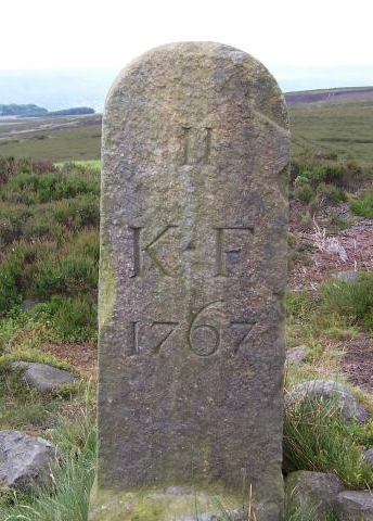
“Father Conmee reflected on the providence of the Creator who had made turf to be in bogs where men might dig it out and take it to town and hamlet to make fires in the houses of poor people”.  So wrote James Joyce in Ulysses, but turbary or peat-digging rights were jealously guarded. And, because of the featureless nature of the landscapes of these mosses – cf the fruitless searches for the Moors Murderers’ victims – disputes were common. Hence we sometimes find turbary boundary stones.

We have looked, so far without success, for turbary stones around Holme Moss; nor are there any yet located in peat-digging areas of Marsden Moor, just north of Holme Moss – again the proliferation of Moss names indicates the peaty areas. Which is why an unidentified stone on the first Austerlands turnpike above Marsden, which we wanted to be a turbary stone, almost certainly isn’t one.

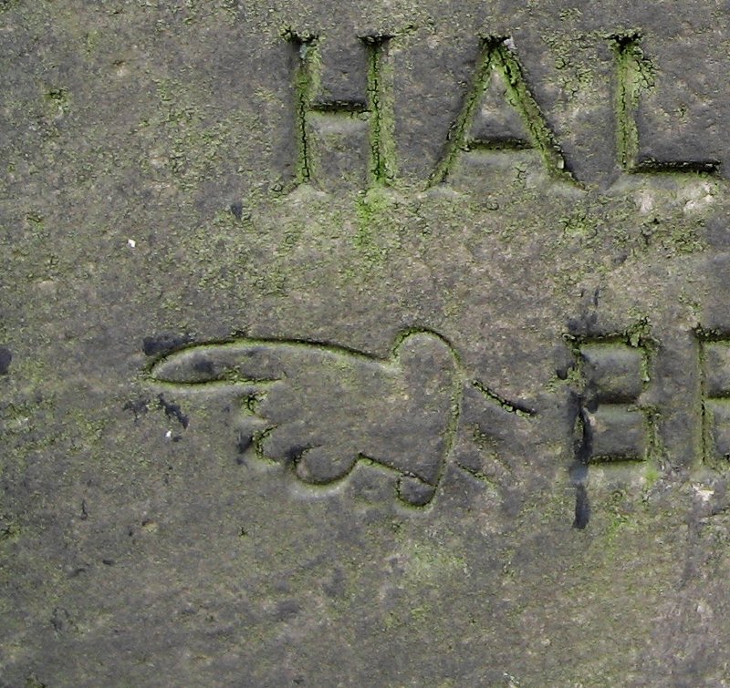
Further north again, however, there are some stones asserting turbary rights (or ‘commons’) in the township of Langfield in the ancient parish of Halifax. This covers a wide, sparsely-populated area south of Todmorden on the West Riding county boundary. There is no standard pattern to the stones, but all have ‘L’ for Langfield, followed by a number. The one illustrated here says “This common doth belong to L…”, but much on the stones is illegible.

Another area where turbary stones are found is further north again, in the Dales, where turbary rights were often in dispute, especially in the 17th century. They have been recorded in the parishes of Austwick, Dent, Stainforth and Thornton-in-Lonsdale, with the largest number in Lawkland. Many, however, have no visible text. The Yorkshire Dales National Park website has further information, a database on a spreadsheet, and a picture gallery.

For more information on peat and peat cutting see a book of the same title by Ian Rotherham (Shire Publications, 2009).  This book is a celebration of a cultural history that extended from the Iron Age to the twentieth century when peat was the main fuel that warmed houses all over the British Isles, and the mark of the peat cutter is written deep in the landscape.  It tells the story of the use of peat for fuel in the British Isles, and the people who cut it. It also examines the methods of cutting, the tools that were used, and the organization of cutting. It chronicles the beginning of commercial extraction and the exhaustion of this precious resource.

Sources: Talk given to the Milestone Society Northern Spring Meeting, 2015, by David Garside; Yorkshire Dales National Park website article (archived); Langfield Common stone illustration © Copyright Humphrey Bolton and licensed for reuse under this Creative Commons Licence.

RWH / rev Sept 2020

Turbary stones Read More »

Milestones around Thirsk

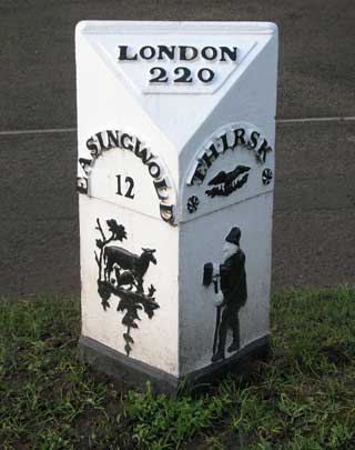
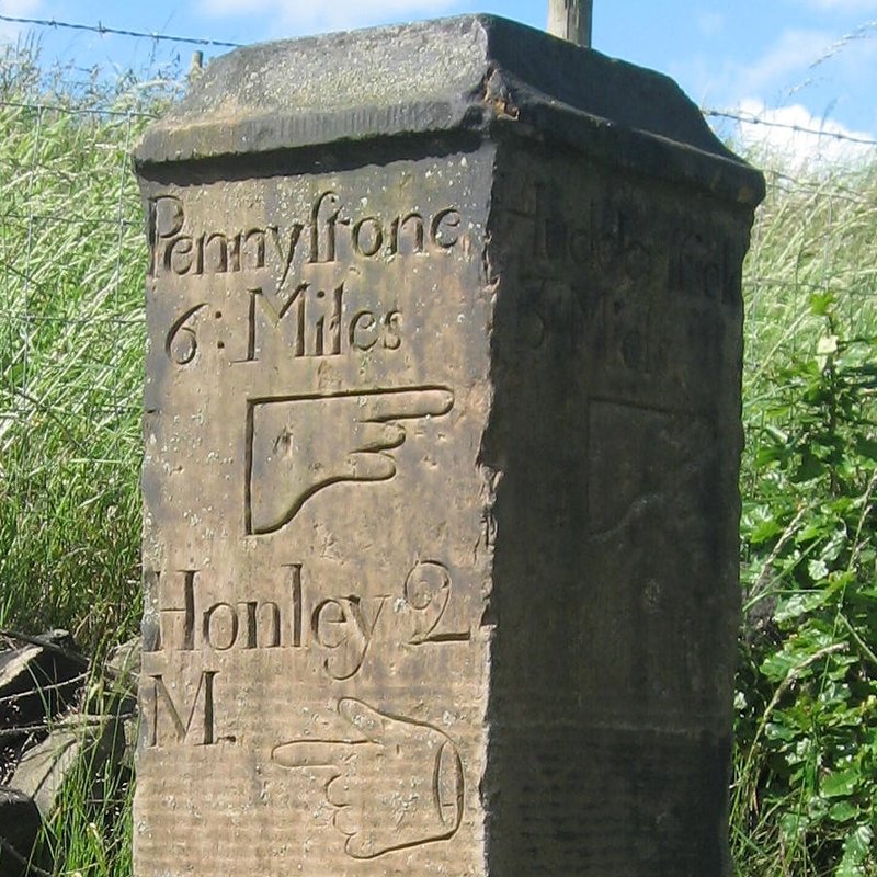
On a number of roads in the vicinity of Thirsk in North Yorkshire are some series of milestones that are all very similar in design, although there is no indication on them of who made them.

One series begins in York on a road originally turnpiked in 1753, through Easingwold and Thirsk to Northallerton – this is now mainly the A19 and A 167 (ignoring modern by-passes). This series actually continues to Darlington (a separate turnpike). The stretch between York and Easingwold has the greatest number of surviving milestones. A road with similar milestones connected Thirsk with Boroughbridge to the south-west, and another with slightly different ones to Yarm (which was of course originally in the North Riding), turnpiked in 1803. Only two stones survive on the latter.

[There was another turnpike that started in Thirsk, to Masham (1755) – now mainly the B6267 – but the only milestone on this road, at Nosterfield, is a later one erected by the Hang East Highway District.]

The milestones all have a number of distinguishing features. They have a triangular cast-iron shape with a sloping top on which the number of miles to London is shown – although not all these mileages are consistent. The lettering is also in a fairly standard font: the local directions are cast in a semi-circular shape around the miles (except for the two surviving Thirsk/Yarm stones, which, perhaps because they are shorter names, are in a straight line).

The most interesting example is in Thirsk itself, opposite no 15, Ingramgate, near the Frankland Arms. This depicts, as part of the original casting, on the left (Easingwold) a lamb and its mother, and on the right (Thirsk) a character with a pint of ale. He has been interpreted variously as Tom the Drover or Tom the Tippler, a colourful local character. Under ‘Thirsk’, in lieu of a mileage figure, is an unidentified symbol, perhaps a bird (or, in the words of Hamlet, “Is it a whale?”).

As for who made the milestones, it would seem likely that they were made in Thirsk, which is fairly central to them all, and because a special one was made for the one in Thirsk itself.

The likeliest candidate would seem to be the ironfounders William and Thomas Chapman, recorded in the 1841 census living at 15 Kirkgate, Thirsk, sons of John Chapman, machine-maker. By 1851 they are still there, unmarried, the head of the household being the now widowed Isabella Chapman. Their foundry is shown on the OS map just north of the church and parsonage. William Chapman died in 1858 and Thomas gave up the business, so it would seem likely that the milestones were produced around the mid 1850s.

Source: based on a talk by Jeremy Howat to the Milestone Society Northern Spring Meeting, April 2015.

RWH/April 2015

Milestones around Thirsk Read More »

Some hands on guide-stoops

The skills of those who carved guide-stoops varied enormously, as these pictures show.

I have just (Jan 2021) discovered that the technical term for a pointing hand is a manicule, although the word is not in most dictionaries, or even the OED online.  [ Update: the word entered the OED in 2022]  This is from a fascinating book on London street signs by Alistair Hall (Batsford, 2020).

Not a standard guide-stoop, this classical structure of 1805, recently restored, is at Ackworth: designed for the traveller on horse-back. A very elaborate sleeved hand on a stoop on Lindley Moor Road in Huddersfield (1735). A rather more primitive hand – at the junction of the B6118 and the road between Kirkheaton and Mirfield.
A nicely-carved hand at Sowerby Bridge. Looks like an afterthought, perhaps by an apprentice who didn’t know what a hand was: at Stone Chair near Shelf; erected 1737. Two different hand styles on the listed stoop at Farnley Moor End, near Thurstonland (1738).

Some hands on guide-stoops Read More »

The Maythorn Way

W B Crump, in his Huddersfield highways down the ages (1949), describes the route of an ancient track leading from Marsden to Penistone, by way of Meltham, Holmfirth, Hepworth, Maythorn and Thurlstone. He also describes five guide-stoops found along the route. Four of these, now somewhat battered, and some no longer in their original locations, survive.
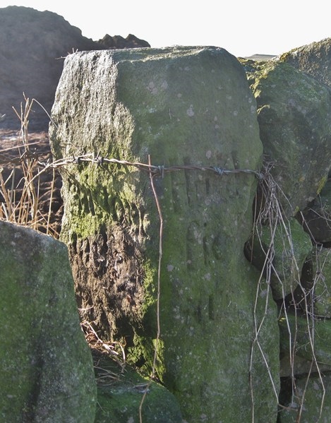
From Marsden the track took the route that later became the first Wakefield-Austerlands turnpike as far as Holthead where the present road turns off to Meltham. Just before Meltham was the first guide-stoop, described by Crump, but now lost.

The second (pictured, right) is just south-east of the centre of Meltham, where Mill Bank Road leads off the B6107 towards Honley (grid ref SE104102). It is sadly virtually illegible, but had distances to Honley, Marsden and Penistone.

The third is a couple hundred yards further on, at the crossroads at the top of the steep Netherthong Road (grid ref SE108099), where a road leads up to the Ford Inn and the A635. Crump records a now invisible hand pointing left to Penistone, with other directions (no hands: “go right” would be assumed) to Holmfirth and Marsden. These directions are a bit of an enigma, since according to Crump the route to Penistone lay through Holmfirth, and one would therefore expect the stoop to be pointing in the same direction to these two places. Also Penistone and Marsden, being in opposite directions, should be on opposite faces but aren’t. Perhaps the stoop was originally elsewhere.

The fourth stoop has had a chequered history, and is now in the middle of Netherthong (grid ref SE138096), a good mile and a half away from its presumed original position. An old Ordnance Survey 2½” map records a milestone at about SE121093, and this is presumably our stoop, being used as a gatepost, and this is how Crump describes it. But obviously it had been moved there at some time as it was some distance from any road or track junctions. Howard Smith, in his Guide stoops of the Dark Peak (1999), suggests that this was at SE119092, where Bradshaw Road crosses Wilshaw Mill Road/Wolfstones Road, but he reports it as missing. It has directions to Marsden, Penistone and Huddersfield.

Crump then describes a route through Holmfirth, Hepworth, Maythorn and Thurlstone to Penistone, though some parts of it are possibly a bit speculative. The only other guide-stoop is on Thurlstone Moor, on the un-made-up High Bank Lane (grid ref approx SE219038), directing to Holmfirth, Huddersfield and Penistone – again in a very poor condition (pictured, right).

There is a stone just inside the grounds of Holmfirth High School (Heys Road, grid ref SE151097) which looks like a guide-stoop, but whatever markings it may have had have been erased. Though not on Crump’s route it is not far from the old crossing of the River Holme at Thongsbridge and could possibly be connected.

And finally, this being about the Maythorn Way, mention should be made of the Maythorne Cross, which has been the subject of legal disputes in recent years. Thought to have originally been a Saxon boundary marker, there are now two Maythorne Crosses, neither particularly original: one in Holmfirth by the river, near the main car-park (grid ref SE144084); the other in a field near its original location near the hamlets of Victoria and Maythorn.

RWH/April 2015

The Maythorn Way Read More »

Street names and road history

Street names and road history

Below is a selection of street name signs with a connection to the history of Yorkshire’s road network. [Sorry, the Milestone Lane pictured above is at Pinchbeck, near Spalding in Lincolnshire – and no longer has a milestone on or near it. The 1887 OS map shows both the name and a milestone, however]


Chain Road, Marsden (though it has no name-plate actually): This is on the present Marsden to Meltham road (B6107), but was originally the 1st and 2nd Wakefield-Austerlands Turnpike.  When the 3rd turnpike was built (the present A62) in 1839, a chain was erected to stop travellers using the old route.  Note the original milestone at right.
Old Turnpike, Honley: The Huddersfield to Woodhead road over Holme Moss originally took a somewhat wiggly course between Honley and Holmfirth; this section heads south from the original Honley Bridge.  A new bridge and straighter road through Hagg Wood was constructed in 1824.
Old Packhorse Road: outside Delph in Saddleworth, joining the present A62, this was the principal pre-turnpike road towards Huddersfield over Standedge.  Some of the route also coincides with the Roman Road at Castleshaw.
New Line: at Greengates, Bradford.  This section of the Shipley and Bramley (for Leeds) Turnpike was straightened at some point in the early 19th century, perhaps when the road was originally constructed in 1826.
Branch Road: usually denotes a branch leading off a turnpike road, perhaps to a nearby village, and usually part of the tolled turnpike. This one is at Scholes, near Cleckheaton, leading to the Leeds and Whitehall Road (now the A58).  There are at least 13 Branch Roads in Yorkshire.
Coach Road, Meltham. To the right the old, direct road to Netherthong, up a steep hill; to the left a later diversion, taking a more gentle route up this very steep section, suitable for horse-drawn vehicles.

Street names and road history Read More »

The Knaresborough Forest boundary stones

The “Forest of Knaresborough” was an ancient area to the west of the present town, first mentioned in 1167, though possibly established even before the Norman Conquest, as a royal hunting-ground. It was not a forest in the modern sense of the word, ie a continuous stretch of woodland, but much more open land. It covered a huge area, around 40 square miles, containing 24 townships between the Rivers Nidd and Wharfe, extending almost as far as Pateley Bridge and Appletreewick.

Stone no 11 at Lippersley Pike

There were attempts to enclose the forest in the 16th and 17th centuries, which all failed due to local opposition. Because of the large number of illegal (though generally small) encroachments that were being made, an investigation was ordered in 1766, resulting in a Commission being set up the following year. This reported that a good deal of the Forest common was “capable of cultivation and improvement”, and the Enclosure Act followed in 1770.
The first task of the Commission, however, had been to establish the forest boundaries. Accordingly a perambulation was announced, starting at Ribston (on the Nidd, three miles south-east of Knaresborough) on September 3rd 1767, with the assistance of local people. The boundary was then marked by a series of round-topped stones carved with a number, the letters K-F, and the date (normally 1767).
There were 49 stones, of which around 30 survive, not all in their original position. The route of the boundary is described in Christopher Butterfield’s booklet (details below), which has photographs of all the surviving stones .

Another more detailed book is by Mike Brough: History and hikes of the ancient royal hunting forest of Knaresborough – in the steps of the 1767 perambulation.  Self-published by the author in 2013, second-hand copies are often available on various websites.

The Commissioners started at the junction of the Nidd and the Crimple (or Crimple Beck), just below Ribston. The boundary follows the Crimple, which flows south of Harrogate, as far as Pannal, where stone no 1 is found, and continues in a clockwise direction to no 49, near the Nidd between Killinghall and Ripley. This is presumed to be the last in the series, as the boundary follows the river back to where the Commissioners started.
Nos 8, 9 and 10 have different dates (1823 and 1825); these are in the parish of Great Timble, and are presumed to be the result of a boundary dispute which took a long time to resolve. Another dispute is possibly responsible for the absence of stones nos 19 to 25 in the lead-mining area around Stump Cross.
Two surviving stones do not conform to the usual pattern (it has been suggested that one stone-mason was responsible for all the stones). These are no 12, at Gawk Hall, on the moors north of Ilkley where four parishes meet, and no 18, at Lord’s Seat, two miles east of Appletreewick. For these the legend has been carved on a large existing natural boulder or outcrop of rock, in situ.

Sources: Christopher Butterfield, comp. and Cyril Mason: The boundary stones of Knaresborough Forest (published by the authors, 6 Ashville Close, Harrogate, HG2 9LZ, 2009); Harrogate WEA Local History Group, ed Bernard Jennings: A history of Harrogate and Knaresborough (Huddersfield: Advertiser Press, 1970); Olwen Middleton: Knaresborough Forest boundaries (Milestone Society Yorkshire News, 2013, no 13, pp 3-5).  Photo by Joe Regan on geolocation.ws.

RWH/June 2013

The Knaresborough Forest boundary stones Read More »

The saga of the Huddersfield 3½ mile “to and from”

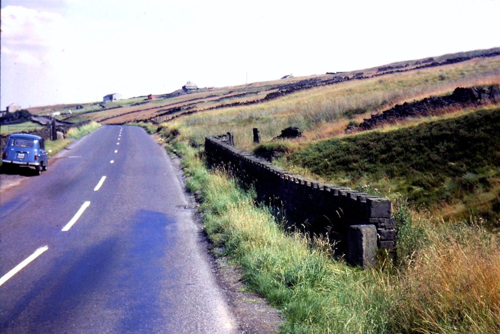
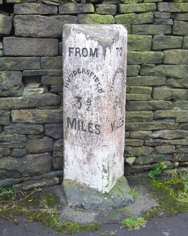
Apart from Stott Hall Farm, nothing stood in the way of the builders of the M62 trans-Pennine motorway as it made its way over the moors and peat-bogs of Rishworth and Scammonden in 1969 – certainly not the old milestone at Outlane informing drivers (and originally cab-passengers) that they were 3½ miles from Huddersfield.

Ray Wilson, a former Huddersfield Town footballer and a member of England’s World Cup-winning team of 1966, could see it from his father’s funeral parlour which overlooked the construction site.  On learning it was about to disappear along with everything else into one of the huge crushing machines on the site, he asked if he could have it, and was told to move it before the machines arrived.

Accordingly, after much strenuous effort (for the stone had as much under-ground as was visible above), it was re-erected in Ray’s garden at Barkisland.  It lived there for 32 years.

When Ray left Barkisland in 2006, he and his wife wanted the stone repositioned in Outlane, and finally, in 2012, following the intervention of the Milestone Society, and as part of Kirklees Council’s milestone refurbishment project, it returned home.

Just a few hundred yards from its original site on the westbound sliproad of Junction 23, it can now be found on the original section of New Hey Road, now a cul-de-sac just on the Huddersfield side of the roundabout.  Painted white, unlike all the other “to and froms”, but already weathered, it was the furthest from the town centre, and the only 3½ mile stone in existence.  They were erected by Huddersfield Corporation in the 1880s or 90s for the purpose of calculating cab fares, which, it is thought, were priced per half-mile.

Source: Milestones & Waymarkers, 2012, vol 5, p 20; Huddersfield Examiner, 29 Nov 2006.  RWH / November 2012

The saga of the Huddersfield 3½ mile “to and from” Read More »

The Kirklees milestones restoration project

In 2006 funding was obtained by Kirklees MBC (covering Huddersfield and district) to restore and conserve the many milestones – there are over 100, not counting an even greater number of boundary stones – in the District. 

A number of Brayshaw and Booth stones on the Wakefield to Denby Dale road (A636) were duly refurbished and then all went quiet.  Persistent enquiries revealed a catalogue of unfortunate events: those involved had retired, been transferred, or made redundant; the depot had been closed; the foundry in Cheshire where the plates had been sent for refurbishment had gone into liquidation.

A happy ending has, however, finally been achieved, and in 2012 a number of stones have re-appeared.  These include stones at Lepton (A642), Grange Moor and Flockton (A637), Holmfirth, and the only 3 1/2 mile Huddersfield “to and from”.  (See separate article for the saga of this stone.) 

Another development has been a “Diamond Jubilee” refurbishment of a Brayshaw & Booth stone at Mirfield.  This has been painted blue, in accordance with the colour stipulated in the original contract in 1893 (see Brayshaw & Booth article), but with gold rather than white lettering.  It looks very fetching, but one can understand why the colour was changed to white, as it is far harder to read.

The Milestone Society is grateful to Kirklees for its continuing commitment to this project.

Source: Milestones &Waymarkers, 2012, vol 5, p 48.  RWH / November 2012

The Kirklees milestones restoration project Read More »

Trods: flagged paths in north-east Yorkshire

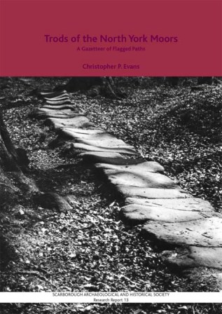
A trod, according to the OED, is a dialect word for a trodden way, a footpath, path, or way.  Brockett’s Glossary of North Country Words in Use of 1825 describes it as a foot path through a field. 
The word is still in use, having been revived by Christopher Evans from Scarborough, who has tramped across miles of field and moorland tracing the route of these old ways across the northern parts of the North York Moors. 
The essential feature of a trod is the single row of large stone flags, as seen on the cover of Evans’ book (pictured right) in an old photograph by Frank Meadow Sutcliffe, the Whitby photographer (1853-1941).  His photographs show a number of trods which have now vanished, and Evans believes that perhaps only 20% of them survive.
Nineteen “long trods” have been identified, some running from the northeast coast southwestwards; some following or crossing dales, such as Eskdale (both the north and south banks) and Glaisdale.  Two notable ones are:
* The “George Gap Causeway”: Blakey Ridge through Rosedale and Great Fryup Dale (a very steep descent, and trods can be very treacherous when wet) to Staithes;
* “Quakers’ Causeway”: from White Cross (just east of Commondale) over Commondale Moor to Guisborough; the present name is obviously later than the trod, which may have a monastic origin, leading as it probably does to Guisborough Priory.
But shorter trods are found all over the moors; they lead to individual farms, mills and churches.  And locally they converge on market towns (and former market towns such as Egton near Whitby, and Castleton in Danby Parish).
There is no single reason why trods were constructed.  They do not tally exclusively with the existence of monastic properties, though many may have such links, and it is probable that monastic labour helped create them – they are even sometimes referred to as Monks’ Trods.  Nor do they tally precisely with the locations of mineral workings (alum, iron or coal), or with the locations of crosses and other waymarkers (although some can be found on them, and many continue to be rights of way today). 
The key factor in any road’s existence, however, is to connect goods from their place of origin with the people who want them: the trods that lead from the coast provide one obvious example, connecting fish with local markets. 
The earliest ones date from mediaeval times, and they were still being constructed in the 18th century: Castleton, for example, did not develop until this later period.
Many trods are vulnerable by running alongside later highways, but the North York Moors National Park Authority is aware of their historical significance, as are some local history groups, and it is hoped that concerted efforts will be made to preserve those that survive. 

Source: talk given by Chris Evans to the Milestone Society at Hebden, April 2012.
RWH / April 2012

Trods: flagged paths in north-east Yorkshire Read More »

The Sedbergh Turnpike Trust and its milestones

A Sedbergh Trust milestone in upper Dentdale

The Sedbergh Turnpike Trust, based in the far north-west corner of the old West Riding, was unusual in that rather than having a single road going from A to B, it comprised five roads all radiating from Sedbergh.

The Act establishing the Trust was passed in 1761/2, and covered the following roads:

  • eastwards to Askrigg in the North Riding; following roughly the line of the present A684, but at Appersett taking what is now a minor road to Hardraw and along the northern side of Wensleydale to Askrigg;
  • westwards to Kendal in Westmorland (1762): the continuation of the present A684:
  • to Kirkby Lonsdale in Westmorland (1762): leaving the Kendal road a mile west of Sedbergh at the Borrett Toll Bar, and heading south along the present A683.  (The present B6256, a couple of miles west of Sedbergh, which connects the Kendal and Kirkby Lonsdale roads, was presumably also turnpiked as there is a milestone on it);
  • north-east to Kirkby Stephen in Westmorland (1765), branching off the Askrigg road at the east end of the town – the continuation of the present A683;
  • south-east to Dent (1802?): the only one of the Trust’s roads completely in the West Riding.  From Dent, mileposts continue on the road on the north side of Dentdale to Cowgill (whose bridge has an interesting plaque – click here for photo) and as far as the Hawes-Ingleton road, suggesting the Trust’s responsibilities extended beyond Dent itself. 

In 1840 the Trust is recorded as having 62 miles of road and seven main gates.

The Sedbergh Trust’s milestones are all to a standard, distinctive pattern:  a rectangular base with up to 50 cm of worked stone, plus rougher stone deeper in the ground; above this is a D-shaped column with a slightly domed top.  The whole is shaped from a single piece of stone and has a rough unworked back.  Destinations are indicated simply by their initial letters – though in Dentdale only the mileage to Sedbergh is shown – and some stones have the township name on the base. 

These milestones survive on all the Trust’s roads except the Hawes road (A684), where they were replaced by the new County Council mileposts (West and North Riding).  Those on the Dent road were presumably considered too minor for the West Riding County Council to replace them in 1894.  Similarly the WRCC did not bother to replace the milestones on the short West Riding stretches of two of the roads which led into Westmorland, to Kendal and Kirkby Lonsdale.

In 1825 the road from Hawes to Kirkby Stephen was turnpiked.  The central section of this, from the lonely Moorcock Inn at Garsdale Head to Appersett, was the existing Sedbergh-Askrigg road; from Appersett the turnpike continued to Hawes and Gayle, and from the Moorcock it went down Mallerstang to Kirkby Stephen.  Its milestones are similar in design to those of the Sedbergh Trust. 

Sources: Geoffrey N Wright: Roads and trackways of the Yorkshire Dales (Moorland Publishing, 1985); Christine Minto: The Sedbergh Turnpike (Milestone Society Newsletter, Jan 2006, no 10, p 17); www.turnpikes.org.uk.
RWH/April 2012

The Sedbergh Turnpike Trust and its milestones Read More »