About Milestones and Waymarkers

We use the term waymarker to cover a wide variety of different stones, posts,, plates and signs generally that tell the traveller where he or she is, or is going to, or which direction to follow when a choice of routes presents itself.
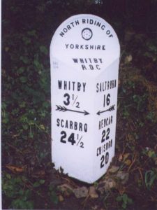
The articles that follow on this and successive pages are a random selection, but if you want something more specific, click on the links here or under Categories at the bottom of the page.

Milestones.
Guide stones (or stoops)
Boundary markers
Bridge markers

Canal mile-markers

Other waymarkers: many other stones and posts can be found on our roadsides and elsewhere.

Roads and travel: there are also some more general articles here on road history.
RWH / updated June 2020

Sowerby Ramble boundary markers

The Sowerby Ramble is not one of the Milestone Society’s Heritage Walks, though perhaps it could be.

Rather it was a peculiar sub-district of Sowerby Township in the Calder Valley west of Halifax.  South of the Calder the townships went, from west to east, Langfield, Erringden and Sowerby.  Erringden township comprised principally the former manorial hunting-ground of Erringden Park, established in the 1320s.  To the north of it, however, between the park/township boundary and the river, was a narrow strip of land belonging to Sowerby.  This was known as Sowerby Ramble, and can be clearly seen on Myers map of 1835 (a section is pictured below: the Ramble is the pink strip).  It is also marked on the first Ordnance Survey map, surveyed in 1848.

Mytholmroyd marked the north-east corner of the Ramble, from where it continued westwards past Hebden Bridge and Eastwood to Stoodley Bridge.  Here a small stream, Stoodley Clough, heads up towards the noted landmark of Stoodley Pike, through what the OS map named as Ramble Wood.  The Ramble followed this stream to a point about half a kilometre east of the monument where it stopped abruptly.  This stretch separated Langfield and Erringden townships.  The Ramble also went south from Mytholmroyd, to the east of Cragg Vale, but much wider in places.

It is thought that its purpose was to provide access for maintenance of the park boundaries, or for cattle or deer herding.  Although the mediaeval park had been sold off several centuries earlier, the Ramble was not abolished until 1850, when it was incorporated into Erringden Township. 

It lives on, however in a series of S marks on stones, gateposts, walls, etc all along the boundary.  Pictured here (above) is one (a reverse S) on the east parapet of the railway bridge on Palace House Road, Hebden Bridge. Others can be found pictured on geograph.org.uk if you search for “sowerby ramble boundary”. When these Ss were carved is not known.  It has been suggested that it may have been around the middle of the 19th century, to preserve the memory of the Ramble, but an earlier date seems more likely.

Sources: A Newell: Sowerby Ramble and Erringden Park (Halifax Antiquarian Society Transactions, 1915, p 233); Nigel Smith: The medieval park of Erringden (Hebden Bridge Local History Society, 2021)

RWH / March 2022

Sowerby Ramble boundary markers Read More »

East Riding mounting-block milestones

The turnpike age arrived in the East Riding in 1744 with a toll-road connecting Hull and Beverley and over the next 50 years others followed, including the road from Beverley to York via Kexby Bridge in 1764.  Milestones, which had been made compulsory in 1767, can be found on almost all of them. 

What is unusual about the East Riding milestones, however, is the number that are not in the common so-called ‘tombstone’ style, but double up as horse mounting-blocks (also referred to as horsing-stones).  They usually have three steps, though a few have only two, quite steep ones.  Historic England, which has listed many of them, describes them as early 19th century, but some are possibly the original ones from the 18th century, and many are badly eroded. 

The place-names and mileages are given on a cast-iron plate attached to the top of the stone.  Some of these have been lost, and many are more modern replacements.  The original stones, however, are thought to have the mileage information carved on them: an example on the A166 near Skirpenbeck, 4 km east of Stamford Bridge has “York 11 miles” on a modern plate on the front, but with the original same details carved in an oval cartouche on the other side.  (Illustration on Geograph).

Nearly half the milestones in the East Riding recorded by the Milestone Society are of this type – 51 in all – more than twice as many as in the rest of Yorkshire.  They can be found, for example, on all but one of the six roads leading out of Beverley, and on the Hull-Hedon and Hull-South Cave turnpikes.

Illustrated here are:

  • (left) a very eroded example at Walkington, on the Beverley to Howden road.  Lacking its plate the hole by which it would have been attached is clearly visible.  The milestones on this road are of the less common two-step pattern, and the steps are rather steep;
  • (right) a plateless stone from Beverley, on the A1035 just west of the town centre;

The restoration of one, Beverley 8 / Malton 20, in 2005 has been documented by the Milestone Society (but not currently traced on website).  The verge level was by then up to the height of the first step, and it was in a dangerous position, having been hit several times; the top step had eroded, and the distance plate was in a sorry state.  The account of the subsequent removal, refurbishment and repositioning in a safer place nearby is a useful account of how it should be done.

Another project was the removal of the Beverley 21 / York 8 stone at Wilberfoss, near the terminus of the Beverley to Kexby BridgeTurnpike Trust.  The Trust was established in 1764, and the road was due to connect from Kexby, on the Riding boundary, to York via the York to Kexby Bridge Turnpike, established a year layer.  Improvements to this road, the present A1079, meant that Wilberfoss was by-passed, and in 2012 the now little-noticed milestone was moved to the new road, where it can be seen by everyone passing with an eye for interesting and historic roadside features.

On some only two steps are visible, but the majority are three-step blocks.  On some two-step blocks it is possible that a bottom step has been covered, following improvements to the carriage-way and associated verge works.  On others the steps are quite deep and so probably were originally two-stepped.  A metal plate of varying design is normally attached to the block.

RWH / Jan 2022

East Riding mounting-block milestones Read More »

B&Bs? Or should we call them Steads?

On nearly 70 roads all over the former West Riding of Yorkshire nearly 400 milestones can be found in a standard style.  Attached to a solid rectangular stone column a metal plate shows destinations and distances.  At the top are the names of the road and the township in which the stone is located.  And between these can usually be found the words Brayshaw & Booth / Makers / Liversedge.  For this reason we tend to refer to these milestones as “Brayshaw & Booths”.

Perhaps, however, we should instead call them Steads.

While Henry Brayshaw and John Booth did cast most of them at their (long gone) foundry in Millbridge, it was Gill Stead and his son Frank, stonemasons in Mirfield, who in 1893 tendered for and won the contract from the newly-formed West Riding County Council for “supplying and fixing 615 milestones upon the main roads in the said West Riding”.  A great-grandson of Gill Stead, Brian Whittaker from Stoke-on-Trent, found a copy of the original contract, which is now available at the West Yorkshire Archive Service in Wakefield.

Gill (1836-1904) was born in Mirfield, the illegitimate son (according to the baptism record) of Ann Stead.  The 1841 census records him living with Joseph Stead, a clothier and presumably a relation, and his wife Mary, at Battyeford.  His mother Ann, meanwhile, is living at Bank House, owned by Benjamin Wilson, described as a landed proprietor in a later census.  Bank House, off what is now Francis Street, was then in extensive landscaped gardens.

Ann continued to live at Bank House, as a servant, until 1857 when she married.  She became the third wife of John Gill, described as a labourer on his marriage certificate and a dairyman in the 1861 census.  It would not be unreasonable to conclude that John Gill was Gill’s father.  Did Ann name her son Gill because she loved his father, or to shame him?

Gill and Mary Stead

Gill does not appear in the 1851 census: apprenticed to become a stone-mason, he was perhaps elsewhere and got left off.  In 1861, now a stone-mason, he is living at Bank House.  Also living there was Mary Taylor, the cook; she and Gill married in 1863.  Later censuses record them with an ever-growing family at various addresses in Mirfield – finally, in 1891 and 1901, on Crossley Lane. 

In 1891 his eldest surviving son, Frank (23), the business partner named in the contract, was also living there.  Ten years later Frank is married with two daughters, but in 1911, with his father dead, he would appear no longer to own the business, describing himself as an employee.  He died in 1919, aged just 51.

Another son of Gill’s, Joseph, who was born in 1871, was also a stone-mason and living with his parents in 1891.  The last census entry for him, in 1911, records him at his widowed mother’s house on Crossley Lane, a stone-mason, a “worker” and married, but other information is frustratingly absent.  His wife, however, appears to be living in Ravensthorpe and taking in boarders.

According to the milestone contract the Steads had to ‘find and provide and be at the expense of all materials, tools, labour, carriage and others matters mentioned or referred to’.  This involved:

  • obtaining and paying for the 615 stones, mainly but not necessarily exclusively from a quarry in Horsforth;
  • commissioning and paying Brayshaw & Booth (or sometimes other ironfounders) to cast and paint the iron plates – each one different, of course, and sometimes with 150 or more characters per stone;
  • transporting them to all parts of the county – from Sedbergh in the north-west (70 miles) to the villages south-east of Rotherham (nearly 40 miles) as well as over the hills to Saddleworth; they may have used horse and cart, or the then more extensive railway network;
  • locating where they were to go (a road measurer had been employed to mark these places with wooden stakes), bolting the plates on, and fixing them two feet into the ground (the stones were six feet long);
  • and finally when in situ giving them another coat of paint.

And all was to be done within twelve calendar months of the date of the contract.

The blue “Stead” at Mirfield

For this mammoth undertaking they were paid £1,140, or £1-18-0d (£1.90) per stone.  And it was all done between August 1893 and August 1894 as stipulated.

One interesting item in the contract states that the milestones were to be painted blue, with white letters, though almost all the surviving milestones are white, with black letters.  Some do in fact show traces of blue paint underneath, but it is not known when it was decided to change the colours.

One, however, was repainted blue in 2012 to celebrate the Queen’s 60th Jubilee, but with gold letters.  Appropriately in view of the local link this is in Mirfield, on the A62 just west of Stocks Bank Road.  If you’ve passed by and not noticed it, that was probably why they re-painted them white.  

Sources: article by Christine Minto in the Saddleworth Historical Society Bulletin, 2015, vol 45 (1), pp 1-17; census records

RWH / Jan 2022

B&Bs? Or should we call them Steads? Read More »

Guide-stones between Otley and Leeds

As well as the turnpike milestones on the road to Otley, another set of stones on the same road is extremely interesting and unique in the county.  There is no word to accurately call them by.  They are often referred to as mileposts as they show distances, in miles and furlongs.  But they occur at road junctions rather than at one-mile intervals.  Here we call them guide-stones, as they list many nearby places.  But although places are listed in a logical sequence they do not appear to show actual directions. 

The places named are often towns and villages, but more frequently they are individual buildings, especially churches – around ten of these – and other landmarks.

Some towns beyond the area are mentioned, once: Bradford, Ilkley, Skipton.  Otley is named once, and its church on four stones.  Leeds itself is not named, but Leeds Bridge, the ultimate end of the turnpike, is listed on eight stones.  Other villages named, both on the line of the road and off it, include Burley, Chapeltown, Meanwood, Old Bramhope  and Tinshill, again usually just once.

More common than the actual villages, however, are their churches, of which 15 are named, from Addingham to Yeadon.  Other landmarks include Otley Chevin (spelt as a rather Germanic Schevin), Pool Bank, Woodhouse Moor; also Bolton Bridge (near Bolton Abbey) and other bridges at Horsforth, Kirkstall and Leeds.  Some houses of local bigwigs are named, though the average traveller was probably not heading for them: Arthington Hall, Cookridge Hall and Kirskill Hall.  The last-named is now known as Creskeld Hall, and has featured as a location in Emmerdale and other TV programmes.  Adel School is listed, sometimes in preference to its notable Norman Church.

Arthington Station is named on several stones, as is Carr Bridge Station.  These stations, part of the original Leeds and Thirsk Railway, now the Harrogate Line, opened in 1849.  The name Carr Bridge Station appears to have been very short-lived: the Ordnance Survey map published in 1851 refers to it as Horsforth Station, and the bridge (over Moseley Beck) is called Horsforth Bridge.  An official accident report of 1849 refers to the station as “Carr Bridge or Horsforth Station” and the accompanying plan names the bridge as Carr Bridge.  The name survives in a couple of nearby, much more recent streets, Carr Bridge Avenue and Carr Bridge View.  [Not to be confused with Carrbridge in Perthshire, whose station did not open until 1892.]

Another transport-related destination was Carlton Bar: the old turnpike went through Carlton township, and the bar and toll-house were at the crossroads with the Dudley Hill – Killinghall road.

The stones are large, with anything up to ten places named, such as one opposite the (currently closed) Dyneley Arms – pictured.  This has the destinations listed on just the front, but others have places listed on two sides  One of these, for example, can be found near the church in Bramhope: it has four on the front, facing the road, and four more on the right-hand side facing up Church Hill.  There are also places where two stones can be found on opposite sides of the road, facing each other; an example is in Bramhope at the crossroads with Breary Lane.

Thus the second stone at the Breary lane crossroads lists, all south and west down Breary Lane:

  • Bramhope Cross
  • Old Bramhope + (ie Cross)
  • Otley Schevin
  • Carlton Bar
  • Guiseley Church

and all north up Breary Lane:

  • Kirkskill Hall
  • Arthington Hall
  • Castley Ford Lane
  • Arthington Station

The peculiar thing about all these stones is that there appears to be no indication of the direction the traveller needs to take to reach the place named.  There is, however, a certain logic to it: places are listed in roughly increasing distance, first towards Otley, and then towards Leeds.  Where there is a pair of stones this is at a crossroads; one stone will list destinations on the main road, and the other destinations on the minor road.  Thus the second stone at the Breary lane crossroads lists:

Places in Adel are named on eight stones.  The school is on four; this is presumably the small building marked ‘Village School’ on the Ordnance Survey map of 1851, and actually on the turnpike road.  A brick yard is on two: White’s 1853 directory of Leeds lists a Samuel Whitaker, brick and tile maker, and the OS map shows a tile yard in an area now occupied by housing.  The beautiful Norman church is mentioned on only one, as is the bridge, about one third of as mile beyond the church over the relatively insignificant Adel Beck.

Since the stones are sited in all the townships through which the road passed they are unlikely to have been put up by the townships, and we presume that they were the brainchild of the Turnpike Trust.  Sources (Wikipedia and others) indicate that the mileposts were erected in 1850, but without specifying which type is meant.  This is probably true for the so-called “tombstone” guide-stones since they cannot have been earlier than 1849 (the date of the stations), and the guide-stones do not appear on the first OS maps (based on surveys begun in 1847).  The turnpike milestones are shown, however, and were probably in position when the road opened in 1842. 

RWH / Jan 2022

Guide-stones between Otley and Leeds Read More »

Teesdale Way parish boundary markers

The River Tees was the traditional boundary between the North Riding of Yorkshire and County Durham.  Local government boundaries in the 20th century have changed this, however.

Spoiler alert: if you’re not very interested in local government history, please skip the next couple of paragraphs.

Firstly the County Borough of Teesside was created in 1968, combining Middlesbrough with Stockton-on-Tees, etc.  This was expanded to create the new county of Cleveland in 1974, which was then abolished in 1996 when four unitary authorities were established.  So Middlesbrough is still for ceremonial purposes in North Yorkshire, though from 2016 part of the Tees Valley Combined Authority, which now includes Darlington, and with a mayor.

And secondly, further west, the parts of the North Riding that formed the Startforth Rural District were transferred to the new Teesdale District in County Durham in 1974.  This was abolished in 2009 when County Durham became a single unitary authority.  The Startforth Rural District villages are now lost to Yorkshire, even for ceremonial purposes, but we in the Yorkshire Milestone Society claim them anyway.

The Teesdale Way is a long-distance footpath, starting (or ending, depending on where you start) at Redcar.  It follows the south bank of the Tees, crossing to the north bank just after Middlesbrough, and then following the river quite closely as far as Whorlton near Barnard Castle.  It then continues, sometimes south, sometimes north, and sometimes on both sides of the river until it reaches Middleton-in-Teesdale, where it joins the Pennine Way.

Between Middleton-in-Teesdale and Gainford (just west of the Great North Road) you will find a series of parish boundary markers – short rust-coloured cast-iron columns resembling chimney-pots or milk churns.  These are in pairs, with the name of each parish carved vertically down the middle.  The following townships or parishes are marked, Y denoting those in Yorkshire: Middleton, Eggleston, Romaldkirk (Y), Hunderthwaite (Y), Cotherstone (Y), Lartingon (Y), Barnard Castle, Startforth (Y), Marwood, Egglestone Abbey (Y), Rokeby (Y), Wycliffe (Y), Westwick, Whorlton, Winston and Gainford.

The boundary markers were created in 1996 by artist and sculptor Richard Wentworth (born 1947).  It was an artwork commissioned by Teesdale District Council and part lottery-funded.  A book about the project, entitled ‘Marking parish boundaries along the Teesdale Way’ by A J Lewery, was published by the Council in 1997.

Illustrated here are the Startforth and Egglestone Abbey markers.  These are on each side of a bridge over the little Thorsgill Beck.  This was originally crossed by an old packhorse bridge, the listed 17th century Bow Bridge, which runs alongside the present one (pictured below).

RWH / December 2021

Bow Bridge, or Thorsgill Beck Packhorse Bridge, with the ruins of Egglestone Abbey

Teesdale Way parish boundary markers Read More »

Boundary disputes

Disputes over boundaries range from the international down to the local – from the arguments that racked Latin America following independence in the 19th century to innumerable arguments locally between townships over unwarranted incursions, either by animals or people.

At least 300,000 Paraguayans lost their lives in the so-called Paraguayan War (or War of the Triple Alliance) in the 1860s, and Paraguay lost a lot of territory.  The break-up of the West Riding in 1974 was perhaps less hotly opposed, and did not lead to bloodshed, but was just the most recent of several centuries of disputes.

Here are a few of them.

In 1614 the free-holders of the Manor of Oakworth, near Keighley, bought an area of land on Oakworth Moor, off the road to Wycoller and Colne.  The Manor of Colne, however, claimed some of this land was theirs.  Despite the Oakworthies claiming, logically enough, that the border – a county boundary – was the watershed, the commission set up to investigate concluded that they were wrong.  And since the Manor of Colne was part of the Duchy of Lancaster, and the Duke of Lancaster was the king, the commissioners obviously knew which side their bread was buttered on. One piece of evidence, however, was the so-called Hanging Stone or Water Sheddles Cross.  Marked as an antiquity by the Ordnance Survey, while Historic England think it probably 19th century and therefore a replacement, this stands on what is still the Lancashire-Yorkshire boundary.  The boundary line is today marked by boundary stones, though many of these say “K C 1902” – presumably denoting Keighley Corporation’s ownership of the land by their nearby Watersheddles Reservoir.  1

LB: Lingards boundary

Lingards was a very small township in the Colne Valley hemmed in by, clockwise from the east, Linthwaite, Meltham and Marsden.  It was later absorbed into Slaithwaite on the north side of the river.  Arguments about the boundary between it and Meltham flourished in the 16th and 17th centuries.  Again it featured moorland, probably as featureless then as it is now, but Lingards had very little while Meltham’s was “spacious”; and again a watershed was claimed as the logical boundary. A plan of 1627 attempted to resolve the dispute though evidence suggests it rumbled on until at least 1641.  A row of boundary stones had been erected, and the boundary today is marked by nearly a dozen stones, incised LB on one side and MB on the other.  One is pictured here. Although these probably date from the 19th century, they are perhaps a reflection of the earlier dispute. 2 

Fixby and Rastrick, 1711

To the north of Huddersfield, on Bradley Road the A6107, and now surrounded by a brick wall, is a stone which reads HERE PARTS FIXBE AND RASTRICKE 1711 — pictured left.  Another stone once stood on the same road, not far away, which read HERE PARTS BRADLEY AND FIXBY.  These were occasioned not by a dispute over bleak moorland, but over road-mending – another major source of disagreements.  In this case the problem was exacerbated by different judgments by separate authorities: the Manor of Wakefield ordered repairs by one township, and the County Sessions by the other.  In 1641 a judgment by the County (which had taken over the Manor’s responsibilities) ordered the townships each to repair the disputed stretch of road in alternate years, but it is not clear why it was another 70 years before one of the boundary markers was erected.  Another stone, now in the Tolson Museum and dated 1761, marked the boundary between Bradley and Firtown (Fartown) – two hamlets in the township of Huddersfield.  This may also be a result of boundary disputes. 3

Langfield’s: keep off!

The townships in the Upper Calder Valley generally have water-courses as their boundaries, reaching up to the watersheds with the surrounding valleys and on the west with Lancashire.  Langfield is one of the exceptions, sharing a long moorland boundary with Sowerby township.  It is a peculiar shape, having what one might term a panhandle to the south.  Its boundaries have been disputed for centuries: there are references to problems as far back as the 14th century, and there was litigation in the early 17th century.  Finally, in the 19th century, the boundaries were fixed by the Ordnance Survey while preparing the first edition 6-inch maps published in the 1850s, though their work was also challenged.  A few boundary stones can be found on the moor, including one, pictured here, on which are chiselled the words “This common doth belong to L…”.  The rest of the word Langfield has been erased, perhaps by someone who thought it didn’t. 4

References

  1. J J Brigg: A disputed county boundary in The Bradford Antiquary, August 1933, new series part 26, pp 1-16.   
  2. George Redmonds: The Lingards and Meltham dispute in his Slaithwaite places and place-names (Lepton: G R Books, 1988), pp 42-47.
  3. W B Crump: Huddersfield highways down the ages (Huddersfield: Tolson Memorial Museum, 1949), pp 119-122.
  4. Nigel Smith: Township boundaries and commons disputes in the South Pennines: Langfield and the case of the Mandike in History in the South Pennines: the legacy of Alan Petford (Hebden Bridge: Hebden Bridge Local History Society, 2017), pp 1-32.

RWH / Nov 2021

Boundary disputes Read More »

Perambulation of Stanbury, 1805

Stanbury is a township in Haworth Chapelry in the Parish of Keighley.  To the west is Lancashire, and its Yorkshire boundaries are with Oakworth on the north, Haworth to the south, and the Halifax township of Wadsworth to the south-west.

A boundary perambulation was carried out on 12th August 1805, and its report, in the archives of the Manor of Bradford, was transcribed in the Bradford Antiquary as follows (with minor amendments)

Manor of Bradford: The Court Baron of Benjamin Rawson, Esq, Lord of the Manor or Lordship of Bradford and the Court for perambulating the boundaries of the township of Stanbury (parcel of the said manor) held at the house of Mathew Wilkinson, the Cross Inn in Stanbury on Monday the 12th day of August in the 45th year of the reign of His Majesty King George III and in the year of our Lord 1805. Before me, Jo. Bentley, Steward.

Names of the Jurors for the Lord of the said Manor: John 5turges Esq, Mr Geenwood Bentley, Mr Joseph Hollings, Mr Thomas Fearnley, Mr John Key, Mr Mathew Watkinson, Mr William Sharp, Mr Jonas Tasker, Mr John Priestley, Mr Jonathan Walton, Mr James Broadbent, Mr Robert Ray

We the above named Jurors at this Court being impannelled and sworn upon the Homage touching the said Court Baron did, on Monday the 12th day of August instant, proceed to perambulate the boundaries of the said Township of Stanbury, and beginning at a Bridge called Smith Bank Bridge we did find the Boundaries as follows, viz.

A stone marked H; photo by David Garside

From the said Bridge we proceeded up the North  side of the Beck called the Sun Beck otherwise Chart Beck to a place called Withens, and from thence we proceeded southwards, along the said Beck, and from the Head of the same Beck southwardly, across certain Inclosed Lands of Joseph Midgley and John Crabtree to certain Stones upon the Moors called the Nooning Stones, and from thence we proceeded southwardly in a direct Iine across the said Moors to a certain stone called Walshaw Dean Head, and marked with the Ietter H; and from the said Stone we proceeded westwardly in a triangular direction along the north side of an old Ditch to a certain place called Backstone Clough Head and from thence to certain Stones called Awcomb Dean Stones; and from Awcomb Dean Stones we proceeded to a place called Robins Ditch; and from Robins Ditch to a place called White Hossocks, and from White Hossocks to Crow Hill Spring and from Crow Hill Spring we went in a northward direction to a certain Stone called “the Lad or Scarr on the Hill”, and from thence we proceeded in a direct Line, northward, to a certain Beck on the south side of the Highway leading from Stanbury aforesaid to Colne, called the North Beck, and then we proceeded along the south side of the said Beck, until we came to a certain Beck called the South Beck, which runs from the said Bridge called Smith Bank Bridge into the said North Beck, and then we proceeded up the north side of the said Beck called South Beck, until we came to Smith Bank Bridge aforesaid, the place at which we began.

The boundary of the township can be seen in its entirety on the Vision of Britain website, and followed in more detail on the first edition Ordnance Survey maps of the 1850s (West Riding nos 199 and 200).  Several names recorded above are not found on the OS maps, and some have changed, either in minor matters of spelling or altogether, as follows:

Smith Bank Bridge: same

Sun Beck / Chart Beck: OS calls it Sladen Beck and higher up South Dean Beck

Withens: the OS shows three places just called Withins; the one highest up the hillside, marked as Ruins on current maps, is Top Withens, allegedly of Wuthering Heights fame.

Nooning Stones: OS: Noonen Stones

Walshaw Dean Head: some confusion here.  Walshaw Dean is a stream that flows into Hebden Water and thence the Calder, with three reservoirs; Walshaw Dean Head is a couple of miles further north, on the boundary with Lancashire.  But obviously Walshaw Dean Head is what Stanbury folk called the point at the southern end of the township where the township met Haworth township.  The stone marked with an H was one of a number erected by Haworth township on their boundary.  Several of these survive, and one is illustrated above.

Backstone Clough Head: not on OS, but possibly what it calls Blue Scar Clough

Awcomb Dean Stones: OS: Alcomden Stones

Robins Ditch: same

White Hossocks: not shown

Crow Hill Spring: same

The Lad Stone; photo by David Garside

“The Lad or Scarr on the Hill”: not named on OS, but this stone still stands at the point where the boundary turns northward.  It is incised with the words LAD OR SCARR ON CROW HILL.  A story is told (with variations) about a boy (or a man) who lost his way in bad weather and died of exposure on Crow Hill, his remains being subsequently buried on the spot.  Haworth and Trawden both disclaimed liability, but in the event Trawden undertook the interment and then claimed an adjustment in its boundary to take in the land as far as the stone. Although there is a ‘kink’ in the boundary, this appears to be another apocryphal tale of tragic death and burial in a remote place.  The word ‘lad’ is common in the Lake Diststrict for a pile or stack, and lad stones are a pile of stones on a mountain top.  It is also occasionally used for a standing stone.

The Highway leading ,,, to Colne: The Two Laws and Keighley Branch of the Toller Lane Haworth and Blue Bell Turnpike Trust. Two Laws was a house, bridge and turnpike bar just east of the county boundary. The Blue Bell was an inn over the border in Lancashire.

North Beck: this is actually the River Worth, but presumably called North Beck because it is north of Stanbury.

South Beck: the same beck as they started from, called Sladen Beck by the OS, but now with a different name from the two given earlier.

Sources: Transcription by W E Preston in the Bradford Antiquary, October 1927, n s part xxii, pp 71-72; John Thornhill: On the Bradford District’s Western Boundary (Bradford Antiquary, 1989, 3rd series vol 4, pp 11-17).

RWH / Nov 2021

Perambulation of Stanbury, 1805 Read More »

Roman milestones

Roman milestones were generally stone pillars with Latin inscriptions erected when a road was first constructed or when it was repaired. The inscriptions usually give the distance to the next, named, town, as well as the name of the reigning emperor and the particular year of his reign in which the milestone was placed, which allows them to be accurately dated.  Over 100 inscribed Roman milestones have been recorded in Britain, according to the Roman Inscriptions of Britain website.

With the exception of one (or perhaps two), all the nine surviving Roman milestones in Yorkshire are in museums, and can be seen as follows.

Aldborough. There are three milestones from Dere Street, the road north to Catterick, in the museum at the Aldborough Roman site, now in the care of English Heritage.  One, dating from the 3rd century AD, was found in 1776 at Duel Cross, about 2 miles from Aldborough.  It was re-used AD 249–51 and given a later inscription: IMP CAES G MESSIVS Q DECI TRA PO FELICI AVG (To the Emperor, Caesar Caius Messius Quintus Trajanus Decius, the good, happy and great from…). It is not known why it was re-used, or whether it retained its use as a milestone or was used as a dedication stone. The last line XX C (20 miles from C) was probably from the original inscription. (Milestones of Decius, RIB no 2276; the other two are nos 2277 and 2278)

Castleford. Castleford lies on a road between Doncaster and Tadcaster (Margary 28b), known generally as Roman Ridge or Rigg. In 1861 it was reported that a milestone had been found at Half Acres, just south of the town centre. It was dedicated to the Emperor Florian in AD 276. It was given to the Yorkshire Museum in York, but is now back home in Castleford, at the Forum Museum, on loan from York Museums Trust. Click here for further details (external site),

Hawes. Two milestones from the road through Stainmore Gap, which crosses the Pennines between Bowes (formerly in the North Riding) and Brough in Cumbria are now in the Dales Countryside Museum – one is pictured on the right. The Roman road roughly follows the line of the present A66 (or more exactly vice versa). This was an important part of the road network by which the Romans controlled the Dales.

Leeds. In about 1880 a milestone was found in central Castleford, near the south end of Beancroft Road at the junction with Beancroft Street. It was cylindrical in shape and had two inscriptions on it. The first was to the Emperor Trajan Decius and dates to AD 250-251. Soon after the stone was turned upside down and a new inscription was added to Gallus and Volusian. It can be dated to AD 251-253. It gave the distance to York (Eboracum) as 22 miles. It was bought by Francis Haverfield, later professor of ancient history at Oxford, who presented it to Leeds City Museum.

Pontefract. The so-called Milestone of Florianus, found in 2002 at Rhydings Farm between East Hardwick and Ackworth, in a hedgebank on the line of the Roman road from Doncaster to Tadcaster (Margary 28b) – as the one at Castleford. Now in Pontefract Museum. Click here for further details (external site).

Rokeby Park: a Palladian country house south-east of Barnard Castle, and formerly in the North Riding. Among other Roman fragments is a milestone of Gallus and Volusian (RIB no 2279): found in the 18th century nearby at Greta Bridge on the Roman road from Scotch Corner to Carlisle.

Besides these the so-called Dial Stone at Slaithwaite is thought to have been a milestone from the road across the Pennines between the Roman forts at Castleshaw, in Saddleworth, and Slack, near Huddersfield. A similar stone can be found in the garden of a house in nearby Golcar and may be another one. See separate article.

Other milestones outside the old county are worth a mention. Two are still in or near their original positions. One is at Middleton, near Lancaster: this has been moved to a safe place in the village churchyard. There is an interesting article on it on the Yorkshire Dales National Park website. (Although the National Park was extended into bits of Lancashire in 2016, it has not yet completely taken over the old enemy). The other one is at Temple Sowerby on a by-passed section of the A66 between Appleby and Penrith. There are no traces of any inscription and only its form and location provide evidence of its former purpose.

The Bowes Museum at Barnard Castle has a milestone found off the Piercebridge – Gainford road, just over the North Riding county boundary,

Sources: links as above; Historic England; https://romancastleford.blogspot.com; www.romanroads.org; https://romaninscriptionsofbritain.org/

RWH / Nov 2021

Roman milestones Read More »

Foiling invaders: waymarkers at war

In 1939, with war looming, an Emergency Powers (Defence) Act was passed enabling the government to make orders as the need arose for the defence of the realm.

One such was the Removal of Direction Signs Order of 30th May 1940.  This was in the middle of the Dunkirk evacuation, when fears of a German invasion were at their peak.  To prevent direction signs being used by an invading army (albeit no doubt armed with maps), all such signs that were visible from a road were to be taken down or otherwise rendered useless.

Daily Express, Friday 31 May 1940

This was reported in the Daily Express of the following day under the headline Signposts to be removed: Sir John Reith, Minister of Transport, announced last night that highways authorities have been instructed to remove signposts and direction indications which would be of value to the enemy in case of invasion. The work was put in hand on Wednesday.

Wooden sign-posts were dug up (or had their arms removed), enamel village signs were unscrewed, and all were put into storage – hopefully to be replaced at the end of the war.  Milestones and boundary stones suffered varying fates: some were removed for safety to council depots, etc; some were covered over with earth, or buried.  A council workman in Norfolk said that his instructions were simply to “dig a trench, push the stones into it and cover them up”.

Others, however, had the ignominious fate of being defaced, their legends chiselled away.  This latter act was contrary to the government’s intentions, as the instructions said clearly that “a chisel should not be used to cut out lettering on milestones”.

Not everyone was happy.   It was reported from the West Riding that milestones were being “chipped with a chisel … and now they are dumb.”  This was clearly seen as an act of vandalism.  “Never since milestones were first put up on the rolling English road have the milestones lost face – except when old age has made them speechless. Their gashed faces now have brought the war to the quietest of country lanes.”

Similar sentiments were evident in Derbyshire, their concern being that “Many of these stones represented an interesting link with the past and one wonders whether it will ever be possible to restore them in their original condition.”  What was of particular concern was that the “old-time spellings and the quaint abbreviations” were not lost forever.

Such fears were not entirely misplaced.  From 1944 the government permitted the re-instatement of signs in inland areas, though labour shortages did not make this a top priority for local authorities.  Many milestones and signposts were replaced after the war, but some buried stones remained buried for many years (and some possibly still are). 

Conversely, some stones still stand in their original locations showing the brutal treatment they have received.  A few examples are pictured below.  Some have had their legends restored, as far as possible, but current thinking is that they should remain as they are: the war is part of our history, and the defacement of milestones is part of their history.

Sources: articles in Milestones and Waymarkers: Keith Lawrence: Emergency powers and the milestones (2014, vol 7, pp 3-6) and David Viner: Emergency powers and the milestones – further examples come to light (2016, vol 9, pp 49-50).

RWH / August 2021

The same, “restored” recently.
Guidestoop in Ripponden at junction
of A58 and B6113 – as defaced.
One of half-a-dozen stones erected by the Borough of Mossley after incorporation at all its boundaries and all similarly defaced. This is on the A635 at the Yorkshire – Lancashire county boundary. It would have read, on the left: County of / West Riding / of Yorkshire [no mention of Saddleworth]; and on the right: County of / Lancashire / Salford / Hundred / Borough of /Mossley.
One of the 1860 Bradfield guide-stoops
Boundary stone on the A643 between Cleckheaton and Gomersal.
Boundary stone on the A62 marking the boundary between Linthwaite and Slaithwaite.

Foiling invaders: waymarkers at war Read More »

Highways Acts: a brief summary

The first Act of Parliament relating to roads was in 1555, and they have followed thick and fast ever since.  This is a brief list of the main ones and what they contained.

1555.  This first act, “for amending of Highways, being now both every noisom and tedious to travel in, and dangerous to all Passengers and Carriages” was passed during the reign of Queen Mary.  It laid responsibility for the upkeep of highways throughout the country on the parish (interpreted as the township in those parts of the north of England with large parishes).  Each highway authority was to elect a surveyor every year whose job it was to maintain the roads in good repair, using the local peasantry who gave their labour unremuneratedly (and no doubt unwillingly).

1663: The Wadesmill to Stilton Turnpike Act.  This was the first ever turnpike act, to improve the road from Wadesmill in Hertfordshire to Stilton (of cheese fame) in Cambridgeshire, along the line of the old Great North Road.  It established the principle that road users should pay for road improvements, although it was over 30 years before the next turnpike act.

1697: An Act for enlargeing Common Highways.  This act permitted the compulsory acquisition of land where the road was too narrow.  More significantly for our interests it made provision for the establishment of guide-stones or posts “where Two or more Crosse High-ways meet”. 

1706: The Fornhill [Bedfordshire] to Stony Stratford [Buckinghamshire] Turnpike Act, covering part of the old Roman Road to Chester, Watling Street.  The half-dozen turnpikes set up after the first were all under the control of the County Justices.  This, however, was the first where the road was effectively privatised, and a board of local worthies, businessmen, etc took it over, and it set the pattern for all future turnpikes

The Wakefield Austerland Act of 1759

1735: The Rochdale to Halifax etc Turnpike Act, the first in Yorkshire.  In the same year there was an act for a turnpike from Manchester to Austerlands, on the Lancashire-Yorkshire boundary, though it was not until 1759 that the continuation to Huddersfield and Wakefield was authorised.

1766: The General Turnpike Act.  A consolidation act repealing all earlier legislation and replacing it with one supposedly simple law.  This was the first general act to require that milestones be set up on all turnpikes, although many individual turnpike acts had already made this stipulation, particularly from the 1740s onwards.

1822: General Turnpike Road Act: another consolidation act.  Among other things this had reference to extra horses being taken on up hills at no extra charge, leading to the small number of “take-on” and “take-off” stones that survive.  It also had a requirement for marker posts at parish boundaries.

1858: Local Government Act.  This act gave parishes and townships the option of becoming Urban Sanitary Districts or combining with others to become Rural Sanitary Districts.  Urban Sanitary Districts were to retain responsibility for their roads.

1862: Highways Act.  This established Highway Districts as the norm for areas where parishes had not become Urban Sanitary Districts.  This applied to most of the rural parts of Yorkshire.  Highway Districts were also to take over the roads operated by failing Turnpike Trusts in the same areas.

1888: Local Government Act.  This created the local government system that prevailed until the reforms of 1974.  It established County Boroughs, responsible for all services (including roads) within their area, and County Councils, which had responsibility for main roads in the rest of the county. 

1894: Local Government Act.  Sanitary Districts became simply Urban and Rural District Councils, UDCs retaining responsibility for minor roads, and RDCs acquiring it with the abolition of Highway Districts.

Sources: W Albert: The turnpike road system in England 1663-1840 (Cambridge U P, 1972); Sidney and Beatrice Webb: The story of the King’s highway (Longmans Green, 1920); vlex.co.uk

RWH / August 2021

Highways Acts: a brief summary Read More »