Uncategorised

The West Riding “Brayshaw and Booth” stones

In 1888 the Local Government Act established County Councils, among whose responsibilities were main roads. In this respect they replaced the highway boards (random collections of parishes) which had been taking over from the steadily collapsing turnpike trusts.
One of the largest county councils was the West Riding of Yorkshire, stretching from Sedbergh in the north-west, to Ripon and the River Ouse on the boundaries of York in the north-east, to Goole in the east, Bawtry in the south-east, Sheffield in the south, and up and occasionally over the other side of the Pennines in the west.
Providing services in such a huge area was always a logistical challenge – even ignoring the fact that large areas in the middle of the county (Bradford, Leeds, etc) were independent county boroughs outside the control of the County Council.  Nevertheless, in 1892, less than four years after it was set up, the Council decided to set up milestones on all its main roads.  No reason is given in the archives: maybe it was seen as a profile-raising exercise.  Efforts to improve the image of local authorities are obviously nothing new.
Accordingly, on 12th October 1892 it was resolved to obtain tenders for the erection of “643 milestones, six inches thick, with iron plates, bolted, showing the name of the road, township and mileage to nearest towns”.  The stone was to come from the Horsforth Quarries, and the milestones were to be 6 feet high, set two feet into the ground.  The estimated cost would be £2-5-0d each.
The contract was awarded to G & F Stead, stonemasons in Mirfield (Gill Stead and his son Frank), who were now to erect 619 stones within 12 months of the date of the contract, 21st August 1893.  They were paid in instalments, the final payment being made in October 1894, so presumably the work was finished on time.  Not only on time, but also under budget: the Steads were paid £1,140, which works out at a mere £1-18-0d per stone.
The whole enterprise must have been an immense undertaking, bearing in mind the distances involved and the transport available (horse and cart).
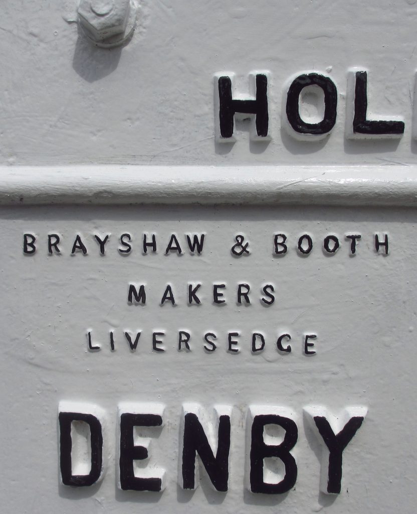
And it would also have been a mammoth task for the firm of Brayshaw and Booth, ironfounders of Liversedge, subcontracted to provide most of the iron plates required.  Their name is displayed prominently on the huge number of their milestones that survive, but little else is known about them: they are listed in trade directories between 1889 and 1917.  Another ironfounder supplying plates was William Towler of Leeds: see separate article.
Over 60 roads have, or had, the new WRCC milestones.  While most will have replaced the existing turnpike trusts milestones, some are on non-turnpiked roads, but some turnpikes were not included.  The major road from Halifax to Todmorden, for example, still retains its original pointing-finger stones.This image has an empty alt attribute; its file name is Barnsley-14-IMG_7723-2-805x1024.jpg
About 350 stones survive, though a few are broken or have lost their plates (and sadly accidents continue to happen).  Some have been restored by Milestone Society members and other agencies such as parish councils.  Rotherham Council has been particularly good at looking after its stones, and Kirklees restored some of theirs some years ago.
Almost all have the protruding triangular iron plates, but eleven stones are wider and flat: these are found where the original road was excessively narrow (as it still is on the oriiginal bridge over the River Holme on Hollowgate in Holmfirth – pictured right); others are in Sherburn-in-Elmet, Elland, Uppermill and Denby Dale.
Another peculiarity is the lettering: sometimes it is horizontal; sometimes at an angle.  There is no pattern to this, though each road is to a standard design.  It is unrelated to the amount of lettering (of which there is sometimes a great deal – up to 160 characters).  Nowadays, as roads and pavements have got resurfaced, some of the information has disappeared under the asphalt.

Traces of blue on a B&B at Elland

A final puzzle is the colour of the original plates.  The contract stipulated that they should be painted blue, and traces of blue paint have been found on some stones (see photo, left).  Perhaps the colour was changed to the almost ubiquitous – and much clearer – white early on, or perhaps it was blue only on the rim, but no reference to this has been traced.  One milestone in Mirfield was painted blue and gold in 2012 to celebrate the Diamond Jubilee; see the article on the Kirklees restoration project for details.

For more information click here for the Brayshaw and Booth picture gallery.

Adapted from an article by Christine Minto, with additions by Stephen Skellern, in On the Ground (no 5, 2008, pp 16-18).   A longer article by Christine was published in the Saddleworth Historical Society Bulletin, 2015, vol 45, no 1, pp 1-17; it is available online.

RWH / revised July 2021.

The West Riding “Brayshaw and Booth” stones Read More »

West Riding bridge markers


In 1602 the West Riding Justices named 48 bridges which were to be kept in repair by the County – a relatively small number considering the size of the county.  A century and a half later Robert Carr and John Watson produced for the Quarter Sessions a “Book of Bridges” with plans and descriptions of 120 bridges and the extent of the obligation of the Riding for the maintenance of each.  At the same time a survey of all the bridges in the county was undertaken by John Westerman and John Gott, which included 308 bridges which were repaired by bodies other than the county – wapentakes, parishes or individuals..

In addition to the actual bridge, the County’s responsibility extended also to the highway for 300 feet from each end thereof.  County bridges were marked by stones and several of these survive, even where the bridges themselves have been widened or rebuilt.  Usually the stone is sited at the bridge, but occasionally they can be found 300 feet from it. 

There are three main types:

  • round-topped stone ones, presumed to be the oldest, with WR carved on them – often now badly eroded – the example here is at Cooper Bridge near Mirfield;
  • triangular stone (or are they concrete?) plates, often painted white and marked WR in black on each side; the example at the bottom left is at Grassington on the Wharfe.  These we presume to be later, as they are usually in very good condition.  There is a  theory is that they could date from a later (1803) bridge act as an indication of a bridge’s fitness for purpose.
  • and a third, less common, type consisting simply of a vertical cross on a round-topped stone.  There are examples of these in the Dales at Hebden (on Hebden Beck where there is also a triangular marker) and Skirfare Bridge (illustrated bottom right) also over the Wharfe.  There is a theory that these bridges may have had a monastic origin, though the stones are much later.

Two particularly interesting examples can be found on the Holme Moss road, the A6024 between Holmfirth and Woodhead.  About one and a half miles south-west of Holmfirth, at Holmbridge, 100 yards from the bridge on each side of the river, stand two stones each marked with the single word County.  Whether these were erected by the Turnpike Trust or, earlier, by the township, Austonley, we do not know.

Another untypical stone can be found at Dunford Bridge, also 100 yards from the bridge: a plain stone with a vertical line cut down the middle.

Sources: West Yorkshire Archives; Milestone Society Newsletter (17, 2009, p 10).

RWH / last updated Jan 2022.

For more illustrations, click here.

West Riding bridge markers Read More »

The Huddersfield “to and froms”

Huddersfield has what we believe to be a unique series of milestones, triangular in section, at half-mile intervals on all the main roads radiating from the town centre, as well as on minor roads.  On one side it gives the number of miles ‘to Huddersfield’ and on the other side the same number ‘from Huddersfield’.  Hence we’ve named them the ‘To and Froms’.  For some time we had wondered what purpose they served, and when they were erected, and now researches in the Council archives have found some of the answers.

About 23 milestones are found on the roads leading to the following places (clockwise from the north): Bradford (with one off this on Fartown Green Road); Leeds; Wakefield; Almondbury; Lowerhouses; Newsome; Woodhead (via Holmfirth); Meltham; Blackmoorfoot (the old Austerlands turnpike); Manchester (the new turnpike); Paddock/Longwood; New Hey (with one off this on the road to Lindley); Halifax; and Halifax Old Road.  Of these the ones to the Huddersfield suburbs were never turnpiked.  There were no stones at the half-mile point from the town centre, and they stopped at the boundary of the pre-1937 Huddersfield Borough.  Milestones at Milnsbridge and Grimescar, originally in Linthwaite and Fixby townships (though the latter is now missing) are standard WRCC Brayshaw & Booth stones – as is one on Bradley Road in the north of the Borough.

The original theory, that they were related to tram fares, which were based on half-mile distances.  Tram services in Huddersfield (the first municipally-operated system in the country) began in 1883 .  But this theory was discounted as there are stones on a couple of roads that trams never served.

The same principle, however, had applied to the earlier (horse-drawn) hackney carriage fares.  Little has been written on cab services at this period, but in 1890 an Annual Inspection reviewed 48 cabs, 33 hansoms, 42 waggonettes and one omnibus.

Trawling through the Highways Committee minutes provided more evidence to confirm the cab-fares theory: in February 1875 the Moldgreen and Dalton Sub-committee resolved “that a distance post be placed at Primrose Hill for the purpose of calculating the Cab fares”.  Primrose Hill is on the Newsome road, one of the non-turnpiked suburban roads.  Note that a post is referred to rather than a stone.

Then in December of the same year the Almondbury & Newsome Sub-committee resolved “that a One Mile Stone and a One and a half Mile Stone be erected at Longley Lane and Lowerhouses”.  We have no reason to suppose that this is necessarily one of the “to and froms”.

Further research on the Highway Committee minutes may provide further details on other stones, but we have to remember that in 1875 most of the Turnpike Trusts were still in operation, so the Corporation would not be able to erect milestones on the turnpikes.

Meanwhile the Watch Committee minutes were also providing information (it was this committee that regulated hackney carriages).  In 1889-90 we find the Fartown, Deighton and Bradley Sub-Committee recommending a revision of the table of distances for cab fares, especially in Fartown, and that these should be measured from the railway station, not the Market Cross.  The minutes also referred to a table of distances being published in the [Corporation] Year Book.

The Year Book having been found, it did contain a Cab Fares page, showing charges were levelled on distances for a minimum one mile and for every succeeding half mile (or by quarter hours). There is a list of distances and fares (2 wheeled or 4 wheeled) from the Market Cross.  This minimum distance explains why there are no half-mile stones as one left the town centre.

There are specific locations for each half-mile point.  On Bradford Road, for example, the 1½ mile point is “A Mark on the wall 11 yards N. of Mr Dewhirst’s entrance gates.”  (This is exactly where the 1½ mile “to and from” stone was situated before being demolished recently by a passing vehicle).  All the datum points mentioned are chapels, toll bars, houses, junctions and suchlike, which indicates that the “to and from” stones were not yet in situ by 1890.

We are hoping that further research will provide conclusive evidence of when these unique stones were erected.

In 2012 the only 3 1/2 mile “to and from”, which was rescued during the construction of the M62, was re-erected at Outlane near its original location.  Click here for the full story.

Sources: Huddersfield Corporation archives as discussed, in West Yorkshire Archives Service at Huddersfield Library; Roy Brook: Huddersfield Corporation Tramways (1983); article by Jan Scrine in Yorkshire Milestones Newsletter.  RWH / revised November 2012.

The Huddersfield “to and froms” Read More »

Some early turnpike milestones in the West Riding

Although the West Riding County Council replaced over 600 milestones on their roads in the 1890s many of the older ones survive, of which these are typical examples.


Milestone in Penistone Parish, A628, Barnsley to Manchester
Grid Reference: SE 248 040
National ID: YS_BNMC07
  Milestone in Queensbury Parish, A644, Brighouse to Denholme road
Grid Reference: SE 097 306
National ID: YW_BHDE06
 

Milestone in Leeds Parish, A660, Leeds to Otley. One of many in this style on the roads between Leeds and Otley – more guide-stoops than milestones.
Grid Reference: SE 268 384
National ID: YW_LEOT04a

   
Milestone in Shipley Parish, A6038, Otley to Bradford. A Leeds Old Triangle stone
Grid Reference: SE 158 386
National ID: YW_OTBF06
  Milestone in Queensbury Parish, A647, Halifax to Bradford
Grid Reference: SE 100 297
National ID: YW_HABF03
  Milestone in Womersley Parish, A19, Doncaster to Selby
Grid Reference: SE 566 178
National ID: YN_DNSY09

Some early turnpike milestones in the West Riding Read More »

Examples of Various 19th Century Milestones

Milestone in Monk Fryston Parish, A63, Selby to Leeds Turnpike Road.  Evidently before the West Riding County Council Brayshaw & Booth milestones, as they refer to its being a turnpike road, but perhaps the WRCC copied the design?
Grid Reference: SE 499 298
National ID: YN_SYLE07
Milestone in Tadcaster Parish, A659 (old A64), Tadcaster to Haltondial Turnpike Road. Similar in style, but the flat form
Grid Reference: SE 484 432
National ID: YN_TCLE00
Milestone in Rossington Parish, A638 (was A1), Doncaster to Bawtry. Milestone made by J. Walkinshaw, Doncaster
Grid Reference: SK 635 987
National ID: YS_DNBW05

Type of milestone used on the roads leading out of Thirsk. The name of the foundry is unknown.

Milestone in Breckonborough Parish, A167, Northallerton to Boroughbridge
Grid Reference: SE 381 837
National ID: YN_NABB07
Milestone in Northalleron Parish, A167, Darlington to Northallerton
Grid Reference: SE_360984
National ID: YN_NADL03
Milestone in Thirsk Parish, B1448 (was A168) Thirsk and Northallerton
Grid Reference: SE_424833
National ID: YN_TKNA01

Examples of Various 19th Century Milestones Read More »

Finger Posts

In 1961 the Worboys Committee was set up to review road signs, and its recommendations were enacted in 1964.  After this date all new signs throughout the country were to conform to standard designs.

There was no requirement to change existing signs, though on main roads this gradually happened.  On minor roads, however, and in more remote parts, many pre-1964 signposts remain (though some county authorities cheerfully disposed of them).  In 2005 their value to the rural landscape was recognised and councils were encouraged to preserve and maintain surviving fingerposts.

Pictured here is a simple East Riding example, at a crossroads near Londesborough on the Wolds.

See also: Cleckheaton fingerposts

Source: Wikipedia

RWH / Oct 15

Finger Posts Read More »