Uncategorised

The Huddersfield Improvement Boundary stones

The Trinity Street stone
At the beginning of the 19th century Huddersfield was a small but increasingly populous township on the north-west side of the River Colne.  Public services were fragmented and mediaeval at best, and accordingly in 1820 the Ramsden family, or some enlightened citizens (it is uncertain which), sponsored an Act of Parliament “for lighting watching and cleansing the town of Huddersfield …”

The Act covered only a part of the town, that within a 1200 yard radius of the market-place, with the River Colne (the traditional boundary between the Huddersfield and Almondbury parishes) forming the boundary on the east and south.  Even this relatively small area was contentious, for it intruded into the areas of the self-governing hamlets of Fartown and Marsh.

This was followed in 1848 by another Act, known as the Huddersfield Improvement Act, whose jurisdiction again extended to the same 1200-yard limit. 

Two boundary stones from this period definitely survive: one on the road to Halifax (A629) on the right-hand side of the road (leaving the town centre), near the brow of the hill; and on Trinity Street, the road to Outlane / New Hey (A640) on the left-hand side, outside no 163.  Both are clearly carved with the letters and date “H. I. B. 1848”.

We believe a third stone exists, on Bradford Road.  This is just after its junction with Halifax Old Road, on the left-hand side of the road leaving the town centre.  It is roughly the same size and shape as the other two stones, but has no marks on it – and the back is buried under the ground level.

Others may have existed, but will have disappeared with later development; and old maps are unhelpful.

The boundary continued as a ward boundary into the 20th century, but by the 1918 Ordnance Survey map boundaries have been rationalised, and although in places the circular line survived, most now follow streets rather than arbitrarily cutting through houses, etc.

Sources: David Griffiths: Pioneers or partisans? – governing Huddersfield 1820-1848 (Hudds Local History Soc, 2008); information from Milestone Society members.  RWH / March 2012.

The Huddersfield Improvement Boundary stones Read More »

Dial Stone at Slaithwaite Manor House

Slaithwaite’s Dial Stone: a Roman milestone

Dial Stone at Slaithwaite Manor HouseIn the 16th century a stone was found in Booth Bank Clough, between Slaithwaite and Marsden, one of the little streams that drops down into the River Colne.  It was set up, in 1587, in the grounds of Slaithwaite Manor House, and became known as the Dial or Dyall Stone.  Despite having been taken, for some unknown reason, to the Isle of Man in the 19th century, and later re-sited outside Slaithwaite Town Hall on Lewisham Road, it can still be seen at the Manor House, off Nabbs Lane in the centre of Slaithwaite.

It is cylindrical, about five feet in height, 19” in diameter and with a circumference of five feet.  There are no signs of any inscription on it.

For a long time it has been thought to be a Roman milestone, and recent excavations by the Huddersfield and District Archaeological Society have shown that it almost certainly is one.  A route connecting the fort at Castleshaw in Saddleworth via Marsden to the fort at Slack, near Outlane on the outskirts of Huddersfield, has long been reported to exist (eg by mapmaker John Warburton in 1720), but its exact line had always been in doubt.  Excavations by the Society over nearly 40 years have now enabled this route to be ascertained much more clearly, and a milestone could well have been erected near the spot where the Dial Stone was found.  The absence of an inscription is not unusual: letters, etc could have been painted on it.

Although the Dial Stone had a sundial positioned on it at one point in its eventful history, it is probable that Dial is an alternative form of the word Devil, from some mediaeval superstition relating monoliths such as this to the Devil.  Roman milestones have elsewhere been referred to as “devil stones”, and one of the milestones now at Aldborough was found at a place still known as Duel Cross – Duel being one of several variant forms of the same concept.  The Devil was thought to be responsible for all sorts of geological formations or prehistoric features (causeways, dykes, ditches, etc).

It has been suggested that a stone that can be seen in a garden in nearby Golcar is also a milestone from the same road.  It is very similar in size and shape.  This is on Church Street near its junction with Manor Road.

Sources: Norman Lunn and others: The Romans came this way (HDAS, 2008); www.roman-britain.org

RWH / rev October 2021

Slaithwaite’s Dial Stone: a Roman milestone Read More »

A hexagonal guide-stoop near Stocksbridge

One of the most unusual guide-stoops in the county can be found just off the A616 Stocksbridge bypass in South Yorkshire: it is, as far as we know, unique in having six sides.

In the absence of pointing fingers, a traveller was to take the road to the right while facing the destination name on the stone.  But here the road layout is far from clear: in fact there are only five routes leading from the stoop in evidence today.

Going anti-clockwise from the north the destinations read as follows:

a)  Peni / stone / Huthe / rsfield / & / Halli / fax.  This route is shown on the modern OS map only as a right of way heading north-north-west from the stone.

b)  Wood / head / & / Mottra[m].  The present Salter Hill Lane; as its name implies, this route is the old saltway from Cheshire via Longdendale to Yorkshire, preceding but following roughly the same route as the 1732-40 turnpike, now the A628; several old milestones survive on it.

c)  Under / bank / & / Brad / field.  Going roughly southwards: the present Underbank Lane.

d)  Shef / field / & / Rotter / eham.  The main continuation of the saltway into South Yorkshire: the present Tofts Lane.

e)  Barns / ley / & / Ponte / fract / 1734 / Don / caster.  There is no obvious route going in this direction from this point.

f)  Wake / field / & / Leeds.  The present Dyson Cote Lane, heading north-north-east. 

The easiest way to find the stone is from the Stocksbridge bypass (A616): take the turn-off south directing to the Steelworks (West Access), followed shortly by the next left turn, which is Underbank Lane, going under the bypass and uphill to the junction.

Sources: English Heritage; and B Elliott: Discovering South Yorkshire (1998)
RWH / March 2012

A hexagonal guide-stoop near Stocksbridge Read More »

Chapelry boundary stones

Up to the 19th century a parish was a parish, for both church and local government purposes.  In the north some parishes were very large, covering many separate settlements.  (The largest was Rochdale, whose huge area extended even into Yorkshire).  For local government purposes these large parishes were divided into townships; Bradford, for example, contained thirteen and Halifax over twenty.  Similarly, for ecclesiastical purposes, because the parish church could be so far away, chapelries were created, and chapels of ease were built in outlying districts (eg at Elland, Heptonstall, Ripponden and Sowerby in Halifax parish).

By the 19th century, however, things were changing, and the Church of England was facing a number of challenges: rapid population growth; the social upheaval caused by the industrial revolution; and the growth of non-conformism.  Its response was to build thousands of new churches, all over England and Wales.

For each one the Ecclesiastical Commissioners would present a draft order to the monarch for the creation of a new chapelry.  These orders were all published in the London Gazette – then as now the repository for all official public notices.  The full text of this is available online at https://www.thegazette.co.uk/, and it has a sophisticated advanced search facility.

The orders follow a standard pattern.  For example, the 1860 order for Upper Hopton St John, in the West Riding, gives firstly the reason for a new chapelry: “at certain extremities of the [parishes] of Mirfield and … Kirkheaton … which lie contiguous one to another … there is collected together a population which is situate at a distance from the several churches of [the] respective parishes”.

Then follows a detailed description (the schedule) of the line its boundary will follow.  Boundary stones are often mentioned: from its stated starting point the Upper Hopton boundary extends “northeastward, for a distance of 3,294 feet, to a point where a boundary stone inscribed ‘U. H. St. J. C. C. 1860, No. 1’ has been placed.”  It goes on to describe the locations of eight more boundary stones.

In the single issue of the London Gazette that includes the Upper Hopton chapelry (no 22440, published on 30th October, 1860) there are no fewer than 25 orders for new chapelries, of which nine have references to boundary stones.  Unlike Upper Hopton, however, most have only two or three.

Where none are mentioned the usual explanation would appear to be that the boundary line is fairly clear, following named roads, or that the boundary is the same as an existing township (or occasionally hamlet) boundary.  Interestingly they do not always follow an obvious existing boundary.

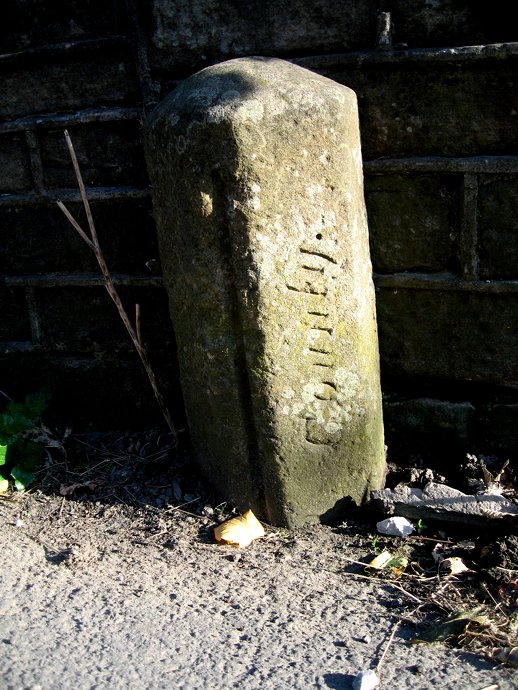
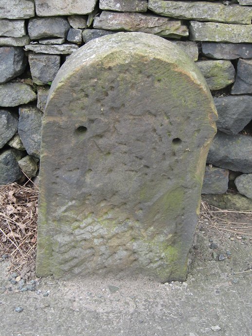
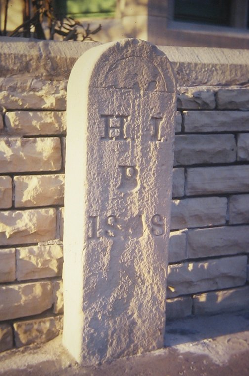
Most boundary stones were carved to a standard format, always using abbreviations.  Thus in the photograph here we have the place name (Batley), the church name (St T – the lowercase t of St has got chipped off here), the chapelry type (here DC for District Chapelry), the date (year), and finally the number as given in the schedule (including No 1 if there is only one).  Chapelries were of two kinds: a district chapelry if the new district was carved out of a single existing parish; or a consolidated chapelry (CC) if it was created out of more than one.

So far in Yorkshire we have found chapelry boundary stones for a number of churches, but many more remain to be tracked down.  This is very much work in progress, but those found so far are:

Abbeydale [Sheffield] St John CC, 1877: at least one of six survive, in Totley; others not yet traced

Batley St Thomas DC, 1869: two of five stones survive

Cleckheaton St Luke District, 1878: no stones traced to date

Dewsbury St Mark CC, 1868: one stone to trace

Dewsbury St Philip CC, 1879: two stones named: to be checked

Girlington [Bradford] St Philip DC, 1860: one stone outside a car showroom on Thornton Road, opposite junction with Hockney Road

Harley Wood [Todmorden] All Saints CC, 1864: one stone – traced 

Helme [Meltham] District, 1854: two stones, both still in situ

Hunslet [Leeds] St Cuthbert CC 1885: two stones listed: to check

Lepton St John DC, 1870: three stones, all still in situ

Mirfield Eastthorpe St Paul CC, 1881: two stones, neither currently traced, though one was photographed c 1985. 

Rawmarsh [Rotherham] Park Gate Christ Church CC, 1869: four stones, to be checked 

Ryhill [near Wakefield] St James CC, 1876: two stones located so far (out of five)

Stanningley St Thomas DC, 1862: at least two of the three stones survive

Thorpe [Sowerby Bridge] St John CC, 1881: two stones, both still in situ

Upper Hopton [Mirfield] St John CC, 1860: originally nine stones, but only one found so far

Windhill [Shipley] Christ Church DC, 1870: one of the five stones has been recorded

As well as these there are others where no stones exist due to later road etc developments.  

The orders in the London Gazette also refer to plans, though these are not published in the journal.  Presumably they exist in the National Archives, and copies may be available in local archives, though their survival locally would appear to depend on the whims of local vicars.  You may find maps showing ecclesiastical parish boundaries, however, on a useful Church of England website,  www.achurchnearyou.com.  This lists every church in England with a map (click on ‘Find us’), which often, but not always, shows the actual parish boundary.  Where churches have amalgamated into teams, however, only the present boundary is shown.

The New Parishes Act of 1843 made a provision that any new ecclesiastical district constituted under the Act would automatically become a new parish when the church had been consecrated.

Source: adapted from a talk to the Milestone Society by Richard Heywood at Hebden, April 2010.  RWH / last updated Jan 2022

Chapelry boundary stones Read More »

The Mattison mileposts of the North Riding

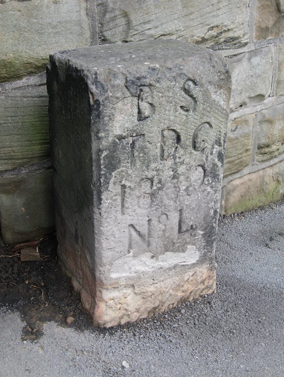
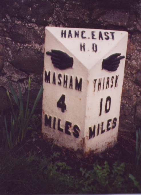
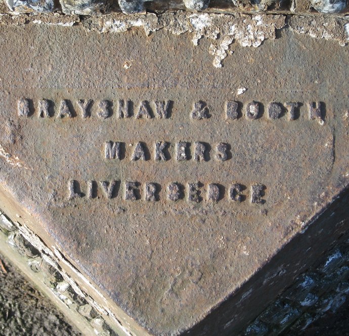
William Mattison of Richmond started a foundry in 1851 on railway company land at Leeming Bar (on the Great North Road in Bedale Parish).  They made almost anything that could be cast in iron, from mill machinery to oven doors. And mileposts.  They made at least three designs of post, of which about 100 survive in North Yorkshire.

The earliest were the triangular posts produced for some local Highways Boards, including Askrigg, Richmond, Hang East  and Langbaurgh West (the last two taking their names from the wapentakes).  (Highway Districts had been set up to maintain major roads in groups of parishes in rural areas.  They became increasingly common after 1862, and also took over any turnpike trusts which became insolvent.)

These have raised pointing hands at the top of each face, though on many posts the hands pointed the wrong way – possibly through mis-information, the founders being confused working with a mirror image mould, or the milepost being erected on the wrong side of the road.  Consequently, new hands were made and fixed over the offending ones; or sometimes the hands were repainted pointing in the opposite direction.  Examples of both can still be seen.  The words F Mattison & Co / Bedale appear inside.

With the establishment of County Councils in 1888 the functions of the Highway Boards were taken over, and there are two designs of posts made for the North Riding County Council.   The more elaborate of these has a round top with a Yorkshire rose surrounded by the words North Riding of Yorkshire; below this, on the bevel, is the name of the RDC (rather than the parish) or UDC.  The direction is indicated by elegant flighted arrows.  The word MILES appears if only one place is named; if more than one, MILES is omitted.  These have the same maker’s name as the Highway District type.

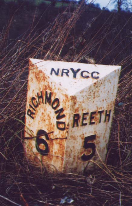
The other, probably later, NRYCC type is much simpler (and cheaper).  Similar to the HD type, but wider (22” compared with 14”), it simply has NRYCC on the bevel, and no hands or arrows.  It has Yorks added to the maker’s name.

By 1913, perhaps when the County Council had completed their mileposts programme, the company was advertising cast iron boundary posts, and claiming to have made “many hundreds“ of boundary posts.

They were taken over in 1937 by John H Gill & Sons Ltd, agricultural engineers, still trading at Leeming Bar.

Main source: Article by Christine Minto in the Milestone Society Newsletter, no 22, Jan 2012, pp34-5.  RWH / February 2012.

The Mattison mileposts of the North Riding Read More »

Terminology found on boundary stones, etc

Borough: a self-governing town, created by royal charter.  Boroughs had existed since Saxon times.  Old Yorkshire boroughs were: Beverley (938), Doncaster (1194), Hedon (1154), Hull (1299), Pontefract (1194), Richmond (1154), Ripon (1605), Scarborough (1181) and York (1141) – dates are those of the first known charter, but some may actually be older.  Population growth in the 19th century saw the creation of Municipal Boroughs (Municipal Corporations Act, 1835) and County Boroughs (Local Government Act, 1888).

Chapelry: in earlier times chapels were built in large parishes where the parish church was far away.  In the 19th century huge numbers of new churches were built, again technically chapels, forming chapelries within existing parishes.  Many of these had boundary stones.  See separate article.
 
Corporation: the governing body of a Borough

County: the traditional division of the country.  Counties, acting through the Justices in Quarter Sessions, had always had a supervisory role in local administration (eg issuing instructions to parish surveyors to erect guide-posts in the 18th century).  They also had responsibilities for bridge maintenance on major roads.  But County Councils, with greatly extended powers, only came into being with the Local Government Act of 1888.

Highway Districts, run by Highway Boards: although the concept was created by an Act of 1835 they became common only after 1862, as mergers of parishes for highway purposes.  Later they started taking over turnpike roads as Turnpike Trusts became increasingly insolvent.
 
Hundred: division of a county – originally an area capable of providing 100 men in times of war; obsolete by mid 19th century.  In Yorkshire these were called wapentakes: a Scandinavian term denoting the brandishing of weapons to signify assent at a public assembly, and hence to the meeting-place, and the territorial division of the county.  Certain other counties had other names for them.

Liberty: a mediaeval unit, originally one in which rights reserved to the king had been devolved into private hands – finally abolished in 1888.

Local Board (of Health): created by Public Health Act 1848.  Parishes and townships could adopt the Act at any time and re-create themselves as Urban Sanitary Districts (qv), controlled by a Local Board.
 
Parish: basic unit of local administration from time immemorial.  Parishes were originally ecclesiastical but increasingly acquired responsibility for civil administration (eg highways in 1555).  In the 19th century there began the separation of these functions: civil parishes became separate entities, and could become local boards (qv).

Rural (Sanitary) District: See Urban and Rural (Sanitary) District.

Township: in less well developed parts of the country parishes were often very large, and further sub-divided into townships (eg Halifax, having over 20).  These had the same functions as single-village parishes. Some townships contained self-governing areas with various names, including: Constablewicks, Districts, Divisions, Hamlets and Quarters.  Huddersfield Township, for example, had four hamlets (Bradley, Deighton, Fartown and Marsh); while Saddleworth was divided into Meres (Friar Mere, Lord’s Mere, Quick Mere and Shaw Mere), which were themselves further split into Divisions (Upper, Middle, Lower)

Urban and Rural (Sanitary) District: Urban Sanitary Districts, administered by Local Boards, were created in 1848, though only for parishes or townships which chose to adopt the Act.  The Public Health Act of 1872 definitively parcelled out the whole of England and Wales into either urban or rural sanitary districts, and in 1894 these became simply Urban Districts or Rural Districts.  Urban Districts were all individual parishes or townships, while Rural Districts were combinations of several (based on Poor Law Unions).  Many Urban Districts were not especially urban in character (eg Holme and Scammonden), but had adopted the Act in order to avoid being merged with other townships for highway purposes: mutual suspicion was as current then as it is now.

Wapentake: see Hundred

Sources: adapted from a talk given by Richard Heywood at the Yorkshire Milestone Society meeting, April 2008.  RWH / January 2012

Terminology found on boundary stones, etc Read More »

The Marsden Packhorse Road Stones

The village of Marsden, on the edge of the Pennine moors in West Yorkshire, has two attractive packhorse bridges: one in the centre, by the church; the other a noted beauty spot at Eastergate, a mile or so up the River Colne.

From the latter a track, the old packhorse road, climbs steeply uphill towards Buckstones on the present A640, and continued to Rochdale. Surviving documents show that this long, straggling path was much used by local carriers in the 18th century, and maintained by the Marsden-in-Huddersfield Township. 

By the late 19th century, however, with the decline of the trade to Rochdale and the development of other forms of transport, the old packhorse route had become little used and had fallen into neglect.  This suited, and played into the hands of, the Lord of the Manor, who resented the effect that passing traffic had on his grouse and was hoping to close the moors.  His gamekeepers were instructed to deter members of the public and threaten “trespassers” with prosecution. 

In 1906 the local Urban District Council, continuing the role of the township highways surveyor, carried out repairs, and matters came to a head.  The Lord of the Manor, Sir Joseph Radcliffe, sued the Council claiming there was no right of way over the moor.

The case was held at Leeds in April 1908.  The Council produced 33 elderly witnesses (the oldest was 92) who recalled using the track as children – ie before the important date of 1835.  The judge concluded that the Lord of the Manor had failed to prove that there was no right of way, but also that the Council had exceeded their rights in the improvements they had carried out.  Accordingly the costs of the case were split between the plaintiff and the defendants.

Among the improvements were 9 stones, carved with the words “P H ROAD”, set up at intervals along the track – a number of which still survive.  These were described by the judge as a “technical trespass”, but did no harm, and might actually help walkers to stick to the path.

Sources: LB Whitehead: Bygone Marsden (c 1942); www.marsdenhistory.co.uk/misc/ph_road_trial.html   RWH / January 2012.

The Marsden Packhorse Road Stones Read More »

Canal milestones

Canals in Yorkshire competed with the turnpikes in the era before the coming of the railways. 
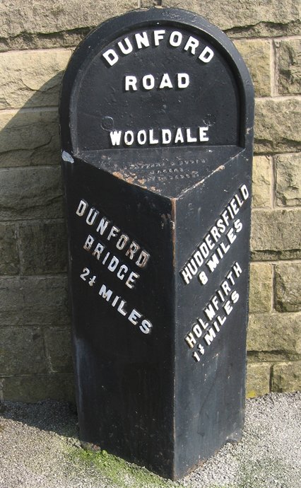
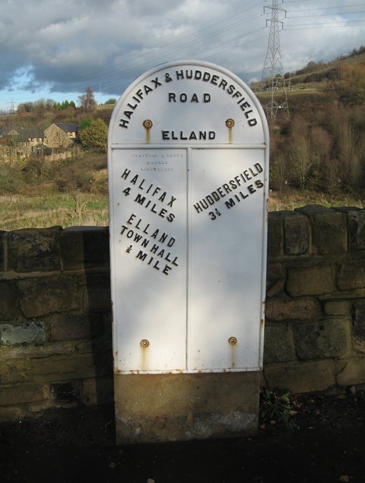
Some, like the Aire and Calder Navigation and the Don Navigation, were built to make the river system navigable. Others, like the Calder & Hebble Navigation (the first part of which opened in 1770) and the Leeds & Liverpool Canal (opened in 1816) were constructed to provide transport routes into the towns and across the Pennines. 

Barge operators charged their customers by the ton and by the mile, so the distance travelled was very important. Most inland canals and some river navigations had milestones. Whereas many roadside milestones have disappeared during road widening, the canals have been little affected and milestones can still be found on the Calder & Hebble Navigation and the Huddersfield Broad and Narrow Canals. The characteristic triangular cast iron mileposts on the Leeds & Liverpool Canal are replacements for earlier milestones, few of which remain today. Replica milestones can also be found on the Rochdale Canal. 

A walk along the canal towpath provides a quiet respite from the bustle of traffic and a chance to find interesting milestones from the canal era.

More photographs to follow.

RWH / January 2012


Canal milestones Read More »

County bridge markers – gallery

Some examples of the county bridge and related stones in Yorkshire.  For more information, click here.

A typical West Riding stone, over the River Skell near Fountains Abbey: a minor road and a minor bridge now, but possibly more important in mediaeval times.
Grid Reference: SE 671 682
Another West Riding example, not a stone but a cast-iron bridge marker, over Hebden Beck, a tributary of the Wharfe at Hebden, between Grassington and Pateley Bridge.
Grid Reference: SE 026 322
From the North Riding, this stone is in the centre of Greta Bridge, near Barnard Castle – a lovely old bridge, now bypassed by the A66.
Grid Reference: NZ 086 132
This image has an empty alt attribute; its file name is Skirfare-Bridge-IMG_0813-2-813x1024.jpg
This plaque is on a small bridge at Cowgill, over the River Dee, near Dent, in Dentdale (now in Cumbria). It reads: This bridg repered at the charg of th West Riding AD 1702.
Grid Reference: SD 761 869
A most unusual example, one of a pair of stones each standing 300 feet from the River Holme, on the A6024 at Holmbridge, south-west of Holmfirth.
Grid Reference: SE 121 068
A cross-type bridge marker on the Skirfare between Kilnsey and Kettlewell, just before it enters the Wharfe.   Grid reference: SD 972 691

County bridge markers – gallery Read More »

WRCC Brayshaw & Booth milestones

These photographs illustrate some features of different Brayshaw and Booth milestones in the old West Riding.

   
A well-looked after stone, one of many in the attractive village of Cawthorne, near Barnsley. Note the horizontal lettering.
Grid Reference: SE
National ID:
  All the Brayshaw & Booth stones in the Saddleworth district, near Oldham, have recently been restored. Note the use of the old “mere” names (the four divisions of the township).
Grid Reference: SE
National ID:
  Just outside Holmfirth, an interesting variant on the usual painting scheme. Here the letting is on a slant.
Grid Reference: SE
National ID:
   
An example of the wider flat stones used where the road was narrow, on the now perfectly wide enough road out of Elland towards Huddersfield. Also recently raised and restored.
Grid Reference: SE
National ID:
  The Brayshaw and Booth name is clearly visible on this otherwise somewhat rusty stone at Lepton, near Huddersfield.
Grid Reference: SE 
National ID: 
  A stone that has lost its iron plate, showing the Steads’ workmanship. This is on the A670 in Saddleworth, near the boundary with Mossley.
Grid Reference: SE
National ID:

WRCC Brayshaw & Booth milestones Read More »