Picture Galleries

Yorkshire, county of many milestones, not to mention waymarkers and boundary stones. In these gallery pages, you will find illustrations of many different types.
Of milestones there are two main divisions. Firstly, those put up before the 1890s, often of stone with details carved in them, erected as a legal obligation by the turnpike trusts who controlled the roads. Then, the new county councils erected cast-iron replacements that still stretch along the main roads and many side roads. Many counties did this, including both the North and West Ridings.
Enough milestones survive along our roads for us to enjoy, though in many districts they are rusty and overgrown. Many of the pictures here are of those milestones that have been cared for, though you will find some that could be transformed with some simple actions.
There are also pictures of other waymarkers – guide-stoops, boundary stones, etc.
JHS / 2010 (rev 2020)

Some Yorkshire bridges

Wakefield’s mediaeval bridge and chantry chapel. The nine-arched bridge, over the River Calder, was built between 1342 and 1356, when the chapel was also consecrated. The new bridge was built alongside in 1929-30.
Marsden’s Eastergate packhorse bridge, on an old route to Rochdale. The original bridge would not have had walls, or the horses’ packs would not have got through.
Aldwark toll-bridge: one of a small number of old toll-bridges surviving in the UK. It is the only crossing of the River Ure between York and Boroughbridge, connecting the villages of Aldwark (in the old North Riding) and Great and Little Ouseburn (in the old West Riding). It was built in 1772 by John Thomson, who had formerly ferried people across in a rowing-boat: he obtained a private Act of Parliament to build the bridge. It’s quite scary crossing it, but well worth the 40p it now costs – though the toll-collector is said to go home at 7.30 pm.
North Bridge, Halifax: a magnificent cast-iron Victorian gothic structure built in 1869 over the rather insubstantial Hebble Brook (and the railway).
Middlesbrough’s Transporter Bridge, completed in 1911.
Scammonden Bridge: photo taken in 1970, when the M62 in a huge cutting below was still under construction.
The Humber Bridge, from the Barton-on-Humber side; opened in 1981. Photograph on Geograph: cc-by-sa/2.0 – © David Wright  https://www.geograph.org.uk/browser/#!/q=humber+bridge/image=263502

Some Yorkshire bridges Read More »

Handstones: guide-stoops on the North York Moors

The ruling about the need for guide-stones in moorland areas was acted on by the North Riding County Justices in 1711 (eleven years after the West Riding).  They ordered that guideposts should be erected throughout the county; they were to be hewn from huge pieces of stone and set up in locations where roads, trackways and  footpaths, used by the numerous packhorse trains (as well as solitary travellers even more likely to get lost on a bad day) crossed.

We call them guide-stoops but locally they are referred to as handstones.  They were relatively plain four-sided upright stone slabs, with the names of villages roughly inscribed on the four faces.  And hands: very crudely chiselled but very distinctive.  The stone-masons, probably illiterate, often had difficulty with the letters and their spacing.

They can be found on Blakey Ridge (north of Hutton-le-Hole), Urra Moor (very worn), Ingleby Moor (with the date 1757) and elsewhere.

Here is a selection.

Sources: Historic England website; anonymous article on ‘North York Moors: guide posts or stoops – known locally as handstones’ (no further details).

RWH / September 2020

The north-facing side of the Blakey Ridge stone. Guisbrough is roughly 15 miles north of the stone, so presumably the hand pointing up in the air means “It’s behind you”. .
The west-facing side of the Blakey Ridge stone. This points down what is now a mere track to Lowna and on via Gillamoor to Kirkbymoorside.
The east-facing side of the Blakey Ridge stone points south down the road to Hutton-le-Hole, about 2 miles away – whence Pickering or Malton can be reached. The stone (Milestone Soc ID YN_XSE6992) is at SE 6936 9255.
The stone on Ingleby Moor in the north-east of the district on a very old track between Ingleby Greenhow and Kirkbymoorside. Milestone Soc ID: YN_XNZ6004. Grid ref: NZ 6040 0422
On the road between Commondale and Kildale, just outside the former. Three hands point to Whitby, Stokesley and Jisber (Guisborough). Milestone Soc ID: YN_XNZ6510. Grid ref NZ 655 105.
A very weathered handstone on Urra Moor. Milestone Soc ID: YN_XNZ5901a. Grid ref: NZ 5943 0150.

Handstones: guide-stoops on the North York Moors Read More »

Some Yorkshire toll-houses

On the A669 at Greenfield
At a private bridge at Copley, Halifax
Stump Cross, Halifax: junction of A6036 and A58
At Scarcroft on the Leeds to Wetherby road, A58
On Rowley Lane, Lepton, once part of the Wakefield Austerlands Turnpike
On the county boundary at Sharneyford, A681 between Todmorden and Bacup
Replica table of tolls on the A616 at Brockholes, New Mill District Roads
In Sussex (sorry!): original toll-keeper’s cottage at the Weald and Dowland Open Air Museum

Some Yorkshire toll-houses Read More »

Some hands on guide-stoops

The skills of those who carved guide-stoops varied enormously, as these pictures show.

I have just (Jan 2021) discovered that the technical term for a pointing hand is a manicule, although the word is not in most dictionaries, or even the OED online.  This is from a fascinating book on London street signs by Alistair Hall (Batsford, 2020).

Not a standard guide-stoop, this classical structure of 1805, recently restored, is at Ackworth: designed for the traveller on horse-back. A very elaborate sleeved hand on a stoop on Lindley Moor Road in Huddersfield (1735). A rather more primitive hand – at the junction of the B6118 and the road between Kirkheaton and Mirfield.
A nicely-carved hand at Sowerby Bridge. Looks like an afterthought, perhaps by an apprentice who didn’t know what a hand was: at Stone Chair near Shelf; erected 1737. Two different hand styles on the listed stoop at Farnley Moor End, near Thurstonland (1738).

Some hands on guide-stoops Read More »

Street names and road history


Below is a selection of street name signs with a connection to the history of Yorkshire’s road network.


Branch Road: usually denotes a branch leading off a turnpike road, perhaps to a nearby village, and perhaps part of the tolled turnpike. This one is at Scholes, near Cleckheaton, leading to the Leeds and Whitehall Road (now the A58)   Chain Road (no name-plate): This is on the present Marsden to Meltham road (B6107), but was originally the 1st and 2nd Wakefield-Austerlands Turnpike.  When the 3rd turnpike was built (the present A62) in 1839, a chain was erected to stop travellers using the old route.  Note the original milestone at right.   Coach Road: This is on the road from Meltham to Netherthong (B6107) – part of an old packhorse road linking Marsden and Penistone.  Because of the steepness of the road leaving Meltham this road for horse-drawn vehicles was constructed taking a (slightly) gentler climb up the hill.
   
New Line: at Greengates, Bradford.  This section of the Shipley and Bramley (for Leeds) Turnpike was straightened at some point in the early 19th century, perhaps when the road was originally constructed in 1826.   Old Packhorse Road: outside Delph in Saddleworth, joining the present A62, this was the principal pre-turnpike road towards Huddersfield over Standedge.  Some of the route also coincides with the Roman Road at Castleshaw.   Old Turnpike: The Huddersfield to Woodhead road over Holme Moss originally took a somewhat wiggly course between Honley and Holmfirth; this section heads south from the original Honley Bridge.  A new bridge and straighter road through Hagg Wood was constructed in 1824.

Street names and road history Read More »

County bridge markers – gallery

Some examples of the county bridge and related stones in Yorkshire.  For more information, click here.

A typical West Riding stone, over the River Skell near Fountains Abbey: a minor road and a minor bridge now, but possibly more important in mediaeval times.
Grid Reference: SE 671 682
Another West Riding example, not a stone but a cast-iron bridge marker, over Hebden Beck, a tributary of the Wharfe at Hebden, between Grassington and Pateley Bridge.
Grid Reference: SE 026 322
From the North Riding, this stone is in the centre of Greta Bridge, near Barnard Castle – a lovely old bridge, now bypassed by the A66.
Grid Reference: NZ 086 132
This image has an empty alt attribute; its file name is Skirfare-Bridge-IMG_0813-2-813x1024.jpg
This plaque is on a small bridge at Cowgill, over the River Dee, near Dent, in Dentdale (now in Cumbria). It reads: This bridg repered at the charg of th West Riding AD 1702.
Grid Reference: SD 761 869
A most unusual example, one of a pair of stones each standing 300 feet from the River Holme, on the A6024 at Holmbridge, south-west of Holmfirth.
Grid Reference: SE 121 068
A cross-type bridge marker on the Skirfare between Kilnsey and Kettlewell, just before it enters the Wharfe.   Grid reference: SD 972 691

County bridge markers – gallery Read More »

WRCC Brayshaw & Booth milestones

These photographs illustrate some features of different Brayshaw and Booth milestones in the old West Riding.

   
A well-looked after stone, one of many in the attractive village of Cawthorne, near Barnsley. Note the horizontal lettering.
Grid Reference: SE
National ID:
  All the Brayshaw & Booth stones in the Saddleworth district, near Oldham, have recently been restored. Note the use of the old “mere” names (the four divisions of the township).
Grid Reference: SE
National ID:
  Just outside Holmfirth, an interesting variant on the usual painting scheme. Here the letting is on a slant.
Grid Reference: SE
National ID:
   
An example of the wider flat stones used where the road was narrow, on the now perfectly wide enough road out of Elland towards Huddersfield. Also recently raised and restored.
Grid Reference: SE
National ID:
  The Brayshaw and Booth name is clearly visible on this otherwise somewhat rusty stone at Lepton, near Huddersfield.
Grid Reference: SE 
National ID: 
  A stone that has lost its iron plate, showing the Steads’ workmanship. This is on the A670 in Saddleworth, near the boundary with Mossley.
Grid Reference: SE
National ID:

WRCC Brayshaw & Booth milestones Read More »

Some boundary stones in Calderdale

The ancient parish of Halifax was the second largest in area in England (after Rochdale).  It comprised 23 townships, though two – Elland-cum-Greetland and Hipperholme-cum-Brighouse – were each made up of two separate entities.  Because of its size chapelries were established in the 13th century in Heptonstall and Elland.

With the exception of Fixby (now in Huddersfield), those parts of Queensbury that were in Northowram, and the parts of Lancashire taken in by Todmorden, its boundary was identical to that of present-day Calderdale.

By the 19th century urban settlements had grown up that did not reflect the township boundaries, and Urban Sanitary Districts were created in Hebden Bridge (taking in parts of Heptonstall, Wadsworth and Erringden) and Sowerby Bridge (taking in parts of Sowerby, Warley, Norland and Skircoat).  Luddenden Foot Local Board was also created out of part of Warley township and a small part of Sowerby over the river.  Todmorden, also not one of the original townships, being at the meeting-point of several, gave its name to both an Urban and a Rural district, while the UD became a Municipal Borough in 1896.

Halifax became a Municipal Borough in 1848 and a County Borough in 1889, expanding to incorporate the surrounding townships

In 1937 a major re-organisation of local government saw many small Urban District Councils merged into larger ones, such as Elland , Ripponden, and Queensbury & Shelf.  All the remaining rural bits west of Hebden Bridge were combined into the Hepton Rural District at the same time.

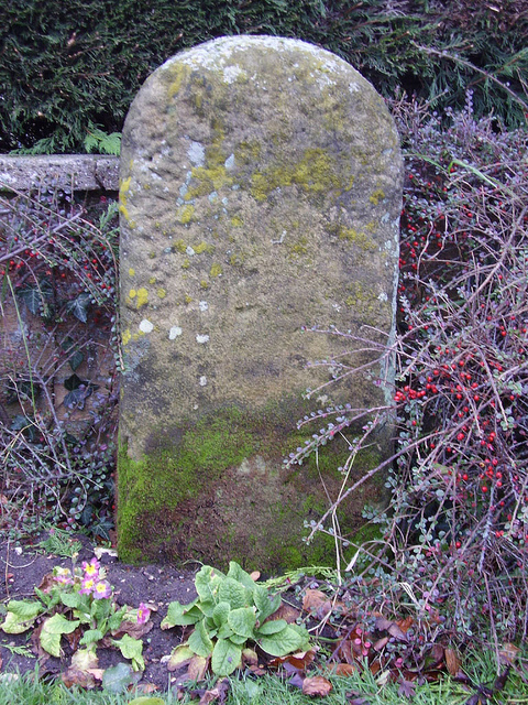
Many boundary stones of the original townships, and later ones, survive of which these are typical examples.

RWH / rev August 2020

 
On Stainland Road (B6112) just outside West Vale
Grid Reference: SE 0910 2067
National ID: YW_GRESTA01pb
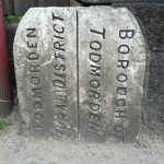
On the main A646 opposite Jumble Hole Road.  Probably erected in 1896 when Todmorden MB was created
Grid Reference: SD 9699 2621
National ID: YW_TOHA02pb
This boundary stone is one of several now in the grounds of Clay House, West Vale.
Grid Reference: SE 0970 2134
National ID: YW_SOYBAR01pb
     
There are many of these stones on the boundary of Soyland township.
Grid Reference: SE 0124 2131
National ID: YW_SOWRIP02pb
This stone stands at the junction of Deep Lane and Butts Green Lane. NB: Luddenden Foot was not an original township, but part of Warley.
Grid Reference: SE 048 252
National ID: not yet registered
This stone survives on the A6036 road between Halifax and Bradford.
Grid Reference: SE 1317 2904
National ID: YW_SHEL01pb

Some boundary stones in Calderdale Read More »

Examples of Various Stone Milestones


Milestone in Penistone Parish, A628, Barnsley to Manchester
Grid Reference: SE 248 040
National ID: YS_BNMC07
  Milestone in Queensbury Parish, A644, Brighouse to Denholme road
Grid Reference: SE 097 306
National ID: YW_BHDE06
  Milestone in Leeds Parish, A660, Leeds to Otley. One of the ‘Leeds Detail’ stones
Grid Reference: SE 268 384
National ID: YW_LEOT04a
   
Milestone in Shipley Parish, A6038, Otley to Bradford. A Leeds Old Triangle stone
Grid Reference: SE 158 386
National ID: YW_OTBF06
  Milestone in Queensbury Parish, A647, Halifax to Bradford
Grid Reference: SE 100 297
National ID: YW_HABF03
  Milestone in Womersley Parish, A19, Doncaster to Selby
Grid Reference: SE 566 178
National ID: YN_DNSY09

Examples of Various Stone Milestones Read More »

Examples of Various 19th Century Milestones

Milestone in Monk Fryston Parish, A63, Selby to Leeds Turnpike Road.  Evidently before the West Riding County Council Brayshaw & Booth milestones, as they refer to its being a turnpike road, but perhaps the WRCC copied the design?
Grid Reference: SE 499 298
National ID: YN_SYLE07
Milestone in Tadcaster Parish, A659 (old A64), Tadcaster to Haltondial Turnpike Road. Similar in style, but the flat form
Grid Reference: SE 484 432
National ID: YN_TCLE00
Milestone in Rossington Parish, A638 (was A1), Doncaster to Bawtry. Milestone made by J. Walkinshaw, Doncaster
Grid Reference: SK 635 987
National ID: YS_DNBW05

Type of milestone used on the roads leading out of Thirsk. The name of the foundry is unknown.

Milestone in Breckonborough Parish, A167, Northallerton to Boroughbridge
Grid Reference: SE 381 837
National ID: YN_NABB07
Milestone in Northalleron Parish, A167, Darlington to Northallerton
Grid Reference: SE_360984
National ID: YN_NADL03
Milestone in Thirsk Parish, B1448 (was A168) Thirsk and Northallerton
Grid Reference: SE_424833
National ID: YN_TKNA01

Examples of Various 19th Century Milestones Read More »