August 2020

A walk along the Calder & Hebble Navigation

This walk takes you from Brighouse to Sowerby Bridge, past milestones, lock and other markers, lock-keepers’ cottages, and 250 years of canal heritage.

Brighouse is accessible from all parts of West Yorkshire by bus and train, and there is an hourly service by train from Sowerby Bridge to return to Brighouse.

Click here for a pdf with full details of the walk, from the Milestone Society website.

RWH / August 2020

A walk along the Calder & Hebble Navigation Read More »

Mileposts and other features on the Rochdale Canal

The Rochdale Canal was the first navigable waterway to connect the Irish and North Seas, connecting Sowerby Bridge (the end of the Calder & Hebble Navigation which was reached in 1770) with the Bridgewater Canal in Manchester.  It thus beat both the Huddersfield Narrow Canal (completed in 1811) and the Leeds-Liverpool Canal (1816).  Although the process started in 1776, an Act of Parliament to allow work to start was not passed until 1794, and it was another ten years before the official opening of the whole canal.

Eight reservoirs had to be built to placate several mill-owners concerned about their water supply.  It was a broad canal, 14 feet wide, running for 32 miles with, initially, 92 locks at first (now 91, locks three and four having been combined).  Lock no 1 was in Sowerby Bridge, and lock 92 in Manchester.  The canal quickly became the most successful commercial highway between Yorkshire and Lancashire, at its height moving almost 1 million tons of products each year.  Railways caused a decline in traffic although the canal continued in commercial use until closed to traffic in 1952 with some sections filled-in. The Rochdale Canal Society was formed in 1974 to work to re-open it, and this finally happened in 2002.

This image has an empty alt attribute; its file name is IMG_0123-2-753x1024.jpg

The following features are still in place:

Stone canal company markers

A handful of these exist, inscribed RCCo, presumably marking the boundary of the canal company land adjacent to the canal.  Examples are at Todmorden (pictured), Luddenden Foot and Mytholmroyd.  The Mytholmroyd stone also has the letters ARSL, presumably the initials of the adjacent landowner.
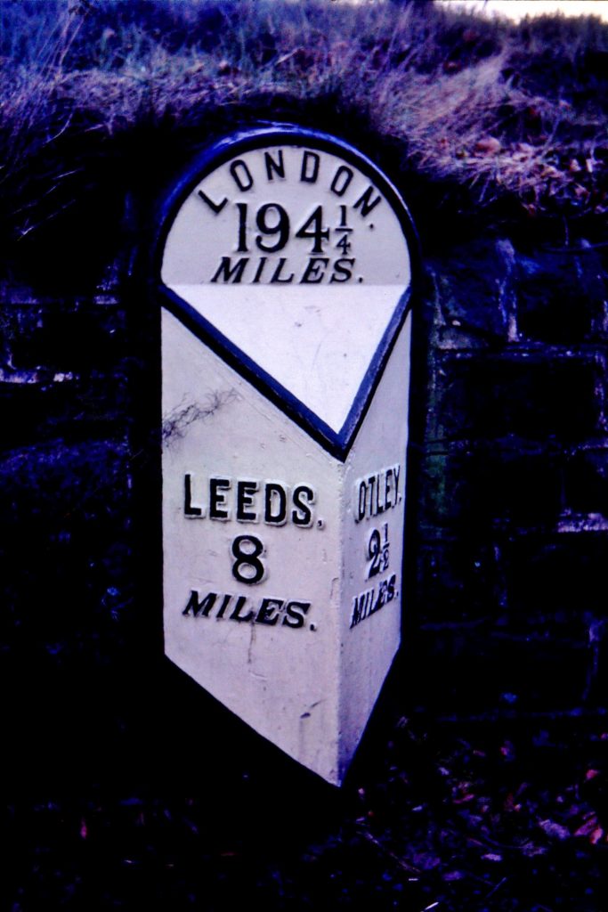
Stone mile posts

This image has an empty alt attribute; its file name is IMG_0123a-2-712x1024.jpg

Only two of the original stones still exist, at Todmorden and Summit.  The Todmorden stone (pictured left) shows ten miles from S (Sowerby Bridge) and 22 from Manr.  The Summit milestone reads simply ‘S 14 M 18’.

Metal mile posts

These are relatively new and have been introduced by the Rochdale Canal Trust (successor to the Society) to mark the re-opening of the canal.  Attractive additions to the canalside scene, there are currently 13 in situ to the county boundary, some of which are more recent replacements.  There is one in Todmorden about 50 metres from the original stone mile-post, and one in

This image has an empty alt attribute; its file name is IMG_0107-2-736x1024.jpg

Sowerby Bridge (no 0) marks the point where the canal connects with the Calder & Hebble Navigation. The one pictured on the right, no 12, is at Walsden, not far from the county boundary.

County boundary marker

Another relatively modern marker is at Warland where the canal crosses the Lancashire – Yorkshire border.

Adapted from an article by David Garside in the Milestone Society Newsletter, Jan 2014, no 26, pp 28-29

RWH / August 2020

Mileposts and other features on the Rochdale Canal Read More »

Milestones on the roads between Otley and Leeds

The original road from Otley in West Yorkshire to Leeds was turnpiked in 1755.  From Otley it went up the steep road past the Chevin, through Carlton township, along what is now called Otley Old Road, becoming Cookridge Lane and turning back into Otley Old Road to the join the present A660 main Otley Road near the ring-road, and on through Headingley into Leeds.  Before this a pre-turnpike road had taken a slightly more westerly line out of Leeds through Burley and what is now West Park.  The 1755 road improved the line through Headingley.

Because of the steepness of the Chevin route a new line was proposed, and the present main road, the A660, was opened in 1842.  This went north out of Leeds through Adel parish, including the township of Arthington: Between Adel and Bramhope it went through Breary Marsh: this was actually part of Arthington township connected by a narrow strip to the village.  It then continued west through Bramhope and Pool into Otley.

Six milestones survive on the original route, presumably dating from the opening of the original turnpike in the middle of the 18th century.  They are all of a distinctive mounting-block style, stone with destinations carved on the front and side.  Most, however, are now badly weathered, or had their destinations erased as a precautionary measure during World War Two.

One of the new turnpike milestones (taken in 1972)

Five milestones erected by the Turnpike Trust on the new route still exist.  They can be found at 1, 6, 7, 8 and 9 miles from Leeds.  They were left in position when the West Riding County Council carried out their milestone replacement programme in the 1890s, presumably because they were relatively new, dating from no earlier than 1842.  They are similar in design to the later WRCC ones: a triangular iron plate attached to the stone.  Unusually, however, at the top where the WRCC milestones (and others in a similar style) give the road or turnpike name, these give the distance to London.  From the last surviving in the series, nine miles from Leeds and 1½ from Otley, we are told that it is 195¼ miles to London.

There is another set of mileposts along this road which are extremely interesting, and unique in the county.  They are referred to as mileposts, though more exactly they are guide-stones, listing anything up to 11 nearby (usually) locations.  The places named are rarely towns and villages, but tend to be individual buildings, especially churches.  Distances are given in miles and furlongs, but the stones do not appear to indicate directions.  W F Seals’ History of Bramhope (1976) says they were put up in 1850, which would tally with the 1849 opening of stations at Arthington and Horsforth (Carr Bridge), which are among the destinations listed.  A separate article on these is available here.

One other stone deserves a mention.  It is in Alwoodley township, so not technically on the Otley-Leeds route.  On King Lane, half-surrounded by houses is a relic of the days when this was in the middle of nowhere: a guide-stone directing travellers south to Leeds and north to Otley, presumably erected in response to the County Justices requirements at the end of the 17th century.

RWH / August 2020

Milestones on the roads between Otley and Leeds Read More »