
Saddleworth boundary stones

Standing on the western side of the Pennine watershed, the area of Saddleworth belonged (and belongs)historically to the West Riding of Yorkshire. Though part of the ancient parish of Rochdale, and transferred to Oldham in Greater Manchester for administrative purposes in 1974, it is still defiantly Yorkshire in spirit.
With a confusing pattern of subdivisions and boundaries, it is hardly surprising that there is a wealth of boundary stones to be found in the district. They are of two types: firstly there are markers to denote where the township met surrounding townships, and secondly there are internal boundary markers, for it was never, until 1937, one unified administrative area.
Following the Norman Conquest it became a part of the Honour of Pontefract, and was divided into four quarters or ‘Meres’ (the word simply means ‘boundary’): Friarmere, Shawmere, Lordsmere and Quickmere. Confusingly the whole district was also once knownsimply as ‘Quick’. The Meres were further subdivided, into Divisions. To complicate matters further, in the 19th century with reforms of local government and the creation of Urban and Rural Sanitary Districts (later Urban and Rural District Councils), Saddleworth appears to have had three units: Springhead Urban District (originally established in 1864 and called Quickmere Middle, though it also included the Upper Division); Uppermill Urban (Sanitary) District (formed in 1868, a small area covering just Uppermill, the largest settlement in the district – on the western edge of Lordsmere); and Saddleworth Rural (Sanitary) District (formed in 1876, and presumably covering the remainder of the district). In 1900 Uppermill and the Rural District were combined to form Saddleworth Urban District, and in 1937 Springhead UD was absorbed into it.
The Meres had by then ceased to have any official role, although the names survive on some of the milestones erected by the County Council in the 1890s. The present-day settlements grew long after the mere boundaries were fixed, but the following lists indicate what was where.
Friarmere belonged to Roche Abbey – hence the name; it had two poetically named divisions:
Dark Side, the most northerly part of the district, including Denshaw and down as far as the outskirts of Delph;
Light Side, including Castleshaw.
Lordsmere, the eastern, and by far the largest, part of the district, including Diggle, Delph, Dobcross, Uppermill, part of Greenfield, and Saddleworth Moor. This was directly controlled by the Lord of the Manor. Boundary stones indicate it had three divisions (Upper, Middle and Lower), though these are not shown on the first edition Ordnance Survey maps.
Quickmere, in the south-west, had three Divisions; from north to south these were:
Upper, a small very sparsely populated area;
Middle, including Scouthead, Austerlands, Springhead, Grotton, Lydgate and Grasscroft;
Lower, the area also known as Quick; the Lower Division was transferred to the newly created Borough of Mossley in 1885.
Shawmere, a small district based on Shaw Hall, between Quickmere and Lordsmere, had two divisions:

Upper, a sparsely populated area between Scouthead and Dobcross;
Lower, including Shaw Hall and part of Greenfield.
Saddleworth had borders with 11 other townships. They are listed here, clockwise from the north, with details of some of the boundary stones to be found:
in Yorkshire:
Marsden-in-Huddersfield: no 1, on the A640 Huddersfield – New Hey road; presumably erected by the Marsden township as it says only MH on one side with no evidence of an S on the other. A series of mounds then follows the boundary south over the moors, past the Standedge crossing, and through …

Marsden-in-Almondbury, with more mounds;
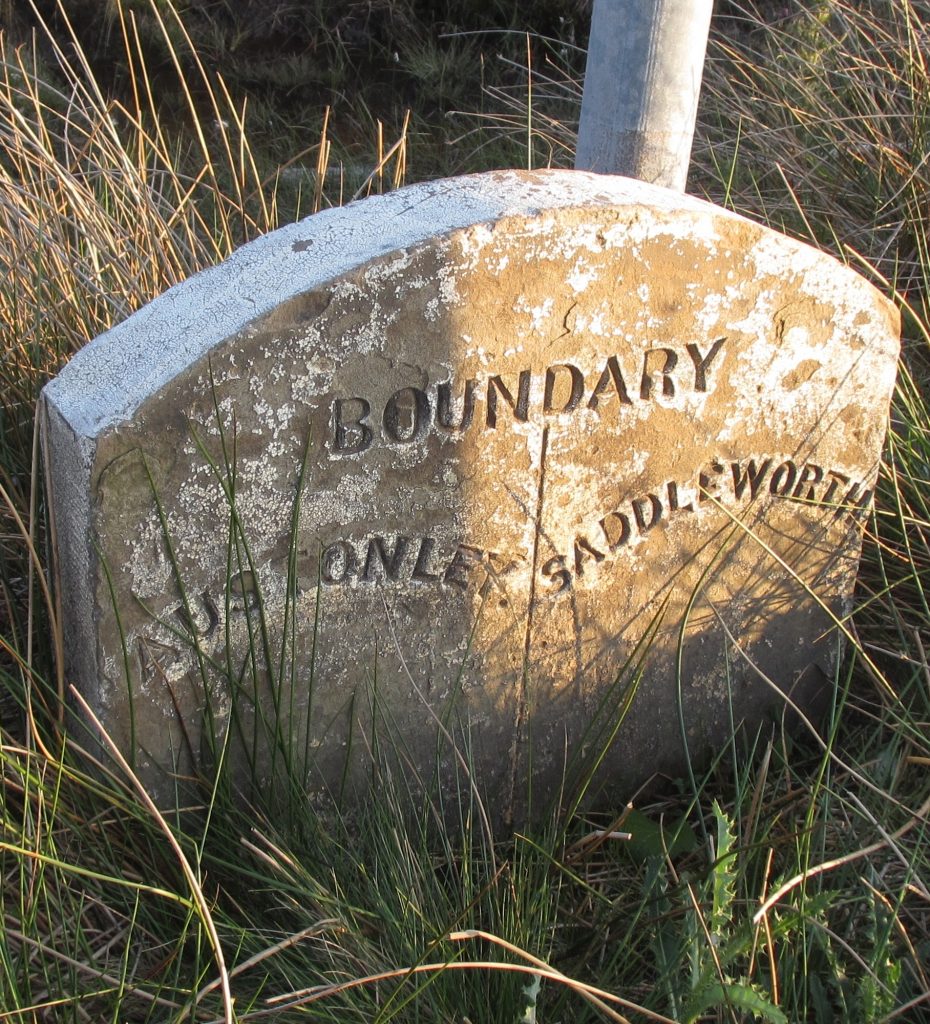
Austonley: a short section on the highest part of the A635 (the Greenfield – Shepley Lane Head road) as it crosses the notorious Saddleworth Moor: no 2.
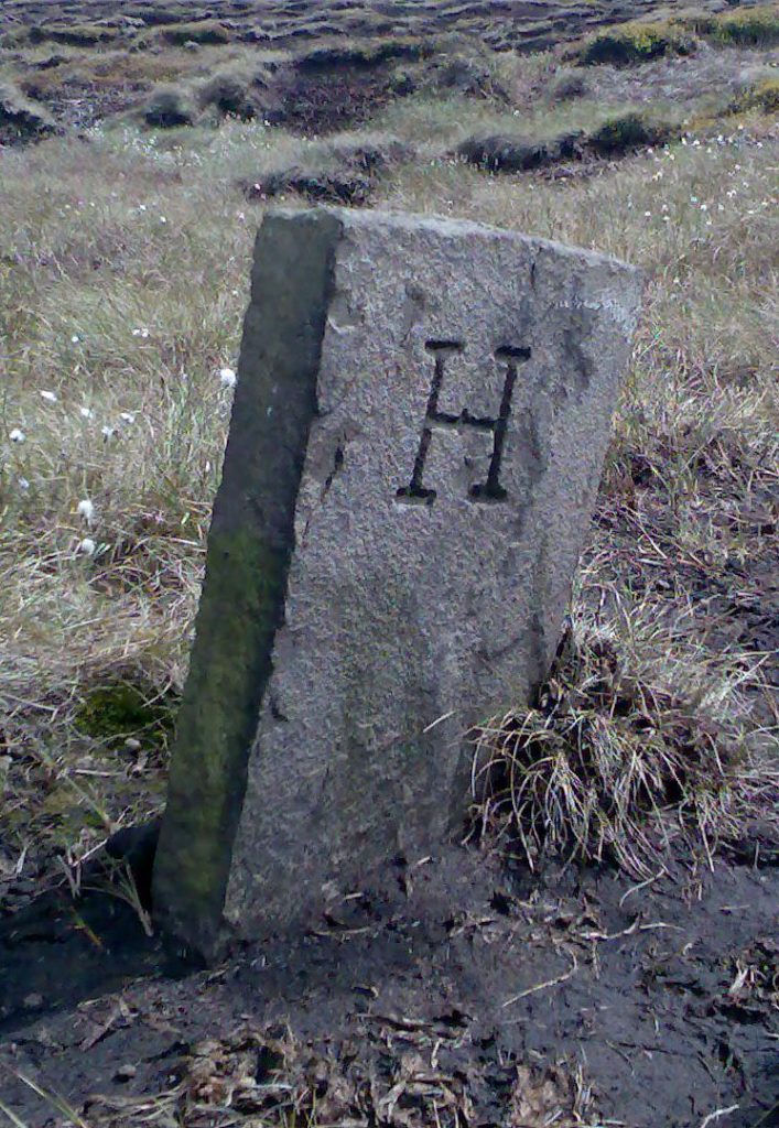
Upperthong: no 3 (photo by David Garside) is half-a-mile south of no 2 on Dean Head Moss, where the boundary line takes a 90o turn. It has S on one side and H on the other: the H is for Holmfirth, so this must have been erected after 1894 when Upperthong was merged with other townships into the new Holmfirth Urban District.
in Cheshire (though transferred to Derbyshire in 1974):
Woodhead and Crowden: two hamlets in Tintwistle township; mounds
Tintwistle: more mounds.
in Lancashire:
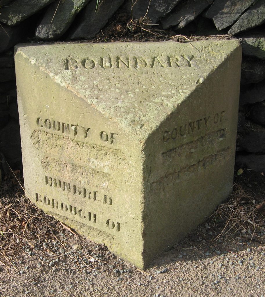
Mossley (part of which was once actually in Cheshire): in 1885 the newly-created Mossley Borough erected boundary stones on all the roads leading into the Borough, all of which were defaced in World War Two to confuse any invaders. At least seven of these survive, including five on the roads into Saddleworth – the A6050, A670, A635, B6175 and the unclassified Under Road. They were most informative, even providing the name of the Hundred (Salford) in which Mossley was situated – but ignoring the detail on the West Riding side. The one pictured (no 4) is on the A670.
Hartshead and Alt: two small townships: no boundary stones traced;
Lees, a narrow township on the A 669, but with a small piece just crossing over the A62: there are two stones on the A62 at Austerlands, erected by the Springhead UD. Going towards Oldham the road enters Lancashire – the stone here mentions Lancashire, but doesn’t bother to mention Lees, which is why we assume it was Springhead who put it up – but after a couple hundred yards re-enters Yorkshire for a very short distance (no 5, which does mention Lees).
Crompton (with its main town Shaw): at Grains Bar on the A672 a stone marks the boundary between Crompton and Friarmere (no 6). The county names, Lancashire and Yorkshire, are on the left- and right-hand sides.
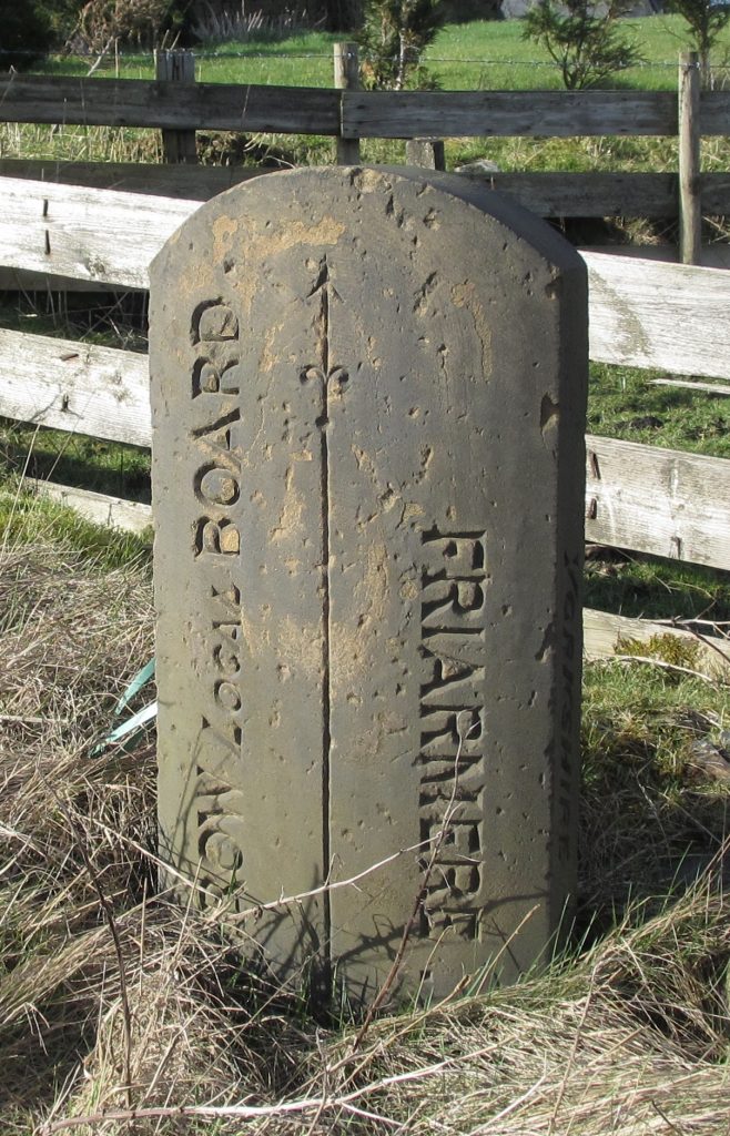
Milnrow: where the A640 New Hey Road (whose other end went through Marsden) leaves Saddleworth (Friarmere again) is a final boundary stone (no 7); this one also names the counties on the sides. The Milnrow Local Board was created only in 1870, before which it was part of an ancient township called Butterworth
The similarity in style of nos 6 and 7 suggests that they were erected by the Friarmere township, presumably sometime between 1870 and 1894 when Local Boards became Urban District Councils.
Then there are several stones marking the boundaries between the Meres, including their Divisions. These are two examples:
No 8: the boundary between the Middle Division of Lordsmere and the Upper Division of Shawmere; this is on the A62 at Delph, opposite the Old Bell Inn.
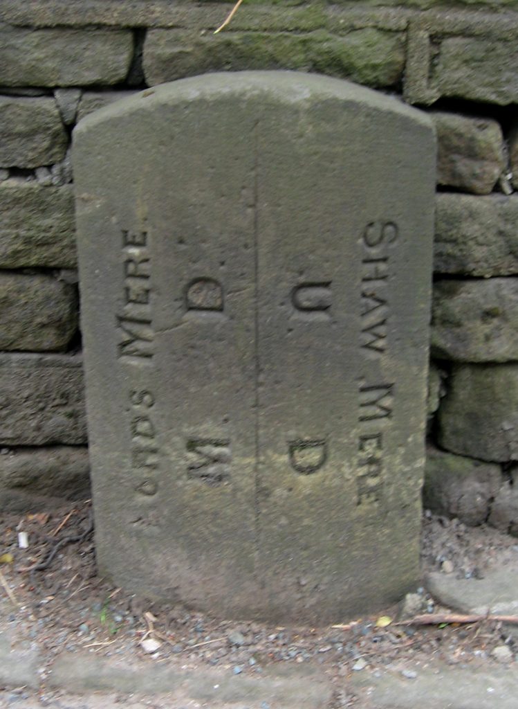
No 9: the boundary between the Lower Division of Lordsmere and the Lower Division of Shawmere: this is on the A689 at Greenfield. Interestingly, the carver was obviously confused here as well, as ‘Lords’ had to be re-carved over something else.

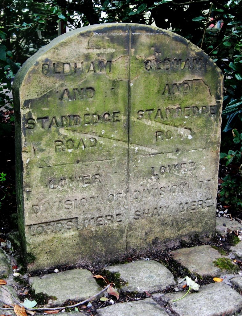
And finally there are examples of the boundaries of the later local authorities. As well as the Springhead UD stones noted above (no 5), there are two stones marking Springhead’s boundary with Saddleworth UD, so dateable to post-1900 when the latter was created. No 10 is on the A669 beyond Grasscroft, the last settlement in Quickmere.
Meanwhile at the northern and southern ends of Uppermill on the A672 are two stones marked simply A ULB BOUNDARY (to the south) and B ULB BOUNDARY (to the north) – put up by the Uppermill Local Board (no 11).
Sources: An article by David Garside in the Milestone Society Newsletter, Jan 2014, no 26, pp 26-27; articles by Mike Buckley on the four Meres in Saddleworth White Rose Society Newsletters, 2009-2010, nos 45 and 46; www.visionofbritain.org.uk; the catalogues of the National Archives at www.nationalarchives.gov.uk; old Ordnance Survey maps at https://maps.nls.uk.
RWH / August 2020
Saddleworth boundary stones Read More »