
Milestones on the roads west out of Halifax
The main road west out of Halifax, King Cross Street, splits in two at King Cross, just over a mile out of the centre. One road, now the A646, leads to Hebden Bridge and Todmorden, and into Lancashire. The other heads down to Sowerby Bridge and Ripponden, where it splits in two again: the A58 heads over Blackstone Edge to Littleborough and Rochdale, while the A672 heads over into Saddleworth (still in Yorkshire) towards Oldham.
All three roads have interesting histories and different milestones.
The Blackstone Edge road
This is a very ancient road, and was the first to be turnpiked, though the actual line has altered over the years. Parts are thought to be originally Roman: the Ordnance Survey describes three sections as Roman Road. Later it was a packhorse road: the paved section coming west off Blackstone Edge is thought to be mediaeval. It was turnpiked in the 18th century, the enabling Act of Parliament of 1735 connecting Rochdale with Halifax and Elland. Rather than continuing from Halifax to Elland there were two branches, one from each town, combining at Ripponden.
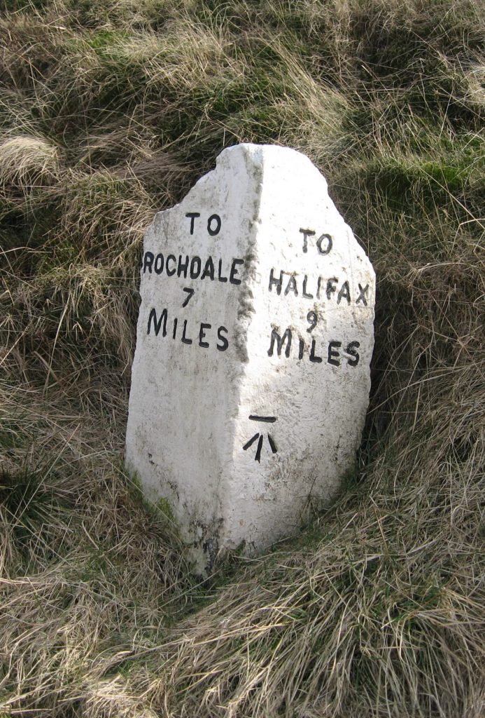
Milestones: for some unknown reason, the original milestones were not replaced by the West Riding County Council in the 1890s, and many survive. From Halifax the first is three miles along the road, just past Sowerby Bridge, though very little of it survives above ground level. Thereafter all but no 6 survive up to the county boundary, many well-cared-for.
The Elland branch also has a run of the same milestones, all four of which are still in position. There is also a stone at the junction in Ripponden acting as a guide-stone. This was refurbished, and the Golden Lion public house opposite renamed The Milestone, in 2011. Some had their destinations erased to foil any German invaders during World War Two, and some have been re-carved.
The road to Todmorden
The Act of Parliament – for “diverting, altering, widening, repairing and amending the Roads from the Town of Halifax, and from Sowerby Bridge, in the County of York, by Todmorden, to Burnley and Littleborough, in the County of Lancashire” – was passed in 1760, though the road was not completed until 1781.
The road to Burnley (still today’s A646) continued to follow the River Calder through the narrow valley bottom – replacing the earlier Long Causeway which ran over the moors between Burnley and Heptonstall. The other branch, to Littleborough where it joined the Blackstone Edge road, provided a longer route to Rochdale, but one less susceptible to bad winter weather. A westward branch off this road led to Bacup and Rawtenstall.
Milestones: from King Cross to Todmorden an almost complete run of very attractive milestones survives. Most are flat with a sort of roll-top, such as the one illustrated, which is at Luddenden Foot. They show the mileages to Todmorden and Halifax, with crudely-carved sleeved hands pointing the direction. The township name is also given, but not always visible now. Two of the milestones, near Todmorden, are of a different style, being two-sided.
While the milestones were thought to date from the late 18th century, Luddenden Foot was not created as a separate district until 1868. It would not normally, therefore, have been named on a milestone. This would mean that they date from the later 19th century – but before 1878 when the turnpike trust was wound up. Being still quite new when the County Council was established this may explain why they left as they were.
Identical milestones exist on the roads beyond Todmorden – as would be expected when they were all part of the same turnpike trust. On the road to Burnley there are eight: three in the West Riding and five in Lancashire (one is lost). There are just two on the road to Rochdale, with none in Lancashire. The Bacup road has three, but again all on the Yorkshire side.
The road to Saddleworth and Oldham

The last of the three roads (now the A672), this road was completed in 1798, following an Act of Parliament in 1795 creating the Oldham and Ripponden Trust. It left the existing turnpike at Ripponden, climbed up to the watershed and went down, briefly through Milnrow and (even more briefly) Crompton (both in Lancashire), back into Yorkshire (Friarmere, the northern part of Saddleworth),and into Oldham, to join what is now the A62 at Waterhead.
Milestones: curiously this is the only one of the three roads to have had its milestones replaced by the Brayshaw and Booth stones of the County Council. Most of these are still in situ, and there is one of the originals (though scarcely recognisable) just over the border on the Lancashire side, in Milnrow (then officially known as Butterworth). The Saddleworth mile-posts use the old division name of Friarmere.

A pre-turnpike guide-stoop still stands, just off the present route, but on an earlier line, possibly moved slightly to be a gate-post. Dated 1735, it has directions to Halifax (7 miles), Huddersfield (8 miles) and Rochdale (8 miles). The distances are the old customary miles, and the routes a traveller would have taken to reach both Huddersfield and Rochdale are barely indiscernible now: the Huddersfield route presumably led through through Scammonden, and the track to Rochdale could have taken various directions.
RWH / August 2020
Milestones on the roads west out of Halifax Read More »