Uncategorised

Milestones on the roads between Otley and Leeds

The original road from Otley in West Yorkshire to Leeds was turnpiked in 1755.  From Otley it went up the steep road past the Chevin, through Carlton township, along what is now called Otley Old Road, becoming Cookridge Lane and turning back into Otley Old Road to the join the present A660 main Otley Road near the ring-road, and on through Headingley into Leeds.  Before this a pre-turnpike road had taken a slightly more westerly line out of Leeds through Burley and what is now West Park.  The 1755 road improved the line through Headingley.

Because of the steepness of the Chevin route a new line was proposed, and the present main road, the A660, was opened in 1842.  This went north out of Leeds through Adel parish, including the township of Arthington: Between Adel and Bramhope it went through Breary Marsh: this was actually part of Arthington township connected by a narrow strip to the village.  It then continued west through Bramhope and Pool into Otley.

Six milestones survive on the original route, presumably dating from the opening of the original turnpike in the middle of the 18th century.  They are all of a distinctive mounting-block style, stone with destinations carved on the front and side.  Most, however, are now badly weathered, or had their destinations erased as a precautionary measure during World War Two.

One of the new turnpike milestones (taken in 1972)

Five milestones erected by the Turnpike Trust on the new route still exist.  They can be found at 1, 6, 7, 8 and 9 miles from Leeds.  They were left in position when the West Riding County Council carried out their milestone replacement programme in the 1890s, presumably because they were relatively new, dating from no earlier than 1842.  They are similar in design to the later WRCC ones: a triangular iron plate attached to the stone.  Unusually, however, at the top where the WRCC milestones (and others in a similar style) give the road or turnpike name, these give the distance to London.  From the last surviving in the series, nine miles from Leeds and 1½ from Otley, we are told that it is 195¼ miles to London.

There is another set of mileposts along this road which are extremely interesting, and unique in the county.  They are referred to as mileposts, though more exactly they are guide-stones, listing anything up to 11 nearby (usually) locations.  The places named are rarely towns and villages, but tend to be individual buildings, especially churches.  Distances are given in miles and furlongs, but the stones do not appear to indicate directions.  W F Seals’ History of Bramhope (1976) says they were put up in 1850, which would tally with the 1849 opening of stations at Arthington and Horsforth (Carr Bridge), which are among the destinations listed.  A separate article on these is available here.

One other stone deserves a mention.  It is in Alwoodley township, so not technically on the Otley-Leeds route.  On King Lane, half-surrounded by houses is a relic of the days when this was in the middle of nowhere: a guide-stone directing travellers south to Leeds and north to Otley, presumably erected in response to the County Justices requirements at the end of the 17th century.

RWH / August 2020

Milestones on the roads between Otley and Leeds Read More »

Three obelisk mileposts at Ackworth

Dotted around the country, with several also in Yorkshire, are mileposts best described as obelisks.  Many date from the second half of the 18th century.  This was before “Egyptomania” took hold in the early 19th century: inspired by Napoleon, a growing number of artefacts came to England – such as the two obelisks brought back to Kingston Lacey in Dorset in the 1820s.

Typical is the famous one at Craven Arms in Shropshire, one of the tallest in the country, showing mileages to 36 towns and cities ranging from Edinburgh to Plymouth.  

They were usually erected by local landowners, and contrasted with the stoops put up by parish and township surveyors – in size and in the quality of the materials and craftsmanship.  The names of neighbouring towns are usually high up, so as to be easily seen by those on horseback.

Three examples can be found on the A628 in Ackworth, south-east of Wakefield. 

The first, standing at a junction outside Ackworth School is the most elaborate.  It comprises a hexagonal column, dated 1805, on top of which is a triangular stone with directions, topped by an urn.  Although the direction-stone is triangular, and it’s a three-way junction, the directions do not follow the standard pattern.  It has an obvious front, facing the school, with fingers pointing left, to Pontefract, and right, to Hemsworth (both three miles).  The two other faces both point in the same direction down the minor road, originally Low Ackworth Lane, now Station Road (though sadly the station closed long ago).  It has directions and pointing fingers to East Hardwick (3) and Snaith (15) on one side, and Went Bridge (3) and Doncaster (13) on the other.  Carved above these, on the urn, is the name Low Ackworth.  A traveller hoping to get to Snaith (historically in the West Riding but now in East Yorkshire) would have needed a lot more guide-posts to reach it through the maze of narrow lanes leading there. (Pictured right)

The urn is a recent addition, following a refurbishment of the obelisk in 2016. Before that it had an ornamental wrought iron stand carrying three lamps, and before that it was originally topped by a round ball or globe – as still seen on the third one.

This is similar to the one outside the school, though less elaborate: less rusticated, a plain hexagonal column, and at the top a ball or globe. Standing in a traffic island at the junction of Pontefract Road and Long Lane, and again a three-way junction, the directions, with pointing hands, are shown in a more logical way. Facing the main road it points to Pontefract (left) and Barnsley (right). The other two sides have directions to York and Darrington, and East Hardwick, and Sheffield (detail pictured at bottom). Under the front is simply the name Ackworth (this is more exactly High Ackworth) and the date 1827.

The third is a different type, and not technically a milepost, as it does not show distances. It is at the corner of Bell Lane, opposite Ackworth Moor Top Quarry, where the stone probably came from, just north of the junction with the Wakefield-Doncaster road. It has a plain undated phallic design, and shows directions to Hemsworth and Sheffield on one side, and Wragby and Wakefield (up Bell Lane) on the other.  Described simply as a stone post on the earliest Ordnance Survey map, the directions named do not tally exactly with the post’s present position. (Pictured left)

All three are too elaborate, and late, for the usual guide-stoops required by the County Justices at the beginning of the 18th century.  The first two are later than the foundation of the school (1779), and earlier than the Barnsley and Pontefract Turnpike of the 1830s. According to J L Saywell in his ‘Parochial history of Ackworth’ of 1894: “To a stranger they possess a commemorative or memorial appearance, but in reality they were erected by the Lords of the Manor, as combination guide- and distance-stones”. He also noted that a lamp surmounted the globe. He does not, however, mention the other (Bell Lane) obelisk, and we do not know when that was erected.

RWH / updated Jan 2022

The plainer High Ackworth obelisk (detail)

Three obelisk mileposts at Ackworth Read More »

Milestones on the turnpike to Meltham

The West Riding County Council erected over 600 new milestones throughout the county in the 1890s, but many roads were not included.  Unless there was a never-proceeded-with plan for a second phase we are yet to find out why these roads, including some major ones, often retain their original turnpike milestones to this day. 

One such road, albeit a minor one, was that from Lockwood (a mile south of Huddersfield) to Meltham, four miles away.  At Lockwood this turnpike left the existing road to Holmfirth which went over Holme Moss into what was then Cheshire (now Derbyshire).  To get to Meltham before this turnpike was constructed travellers (including goods from Meltham’s growing textile industry) had to take one of various roundabout routes (eg from Huddersfield via Blackmoorfoot).

The turnpike trust had been established quite late, in 1818.  It was never popular, and in 1874 the Meltham Local Board petitioned, successfully, for it to be wound up.  They complained that the trust had collected tolls but paid nothing for repairs to the road, which the township had had to make.  Also, companies taking goods to the station at Meltham used only a short length of the road but still had to pay large tolls.  The railway branch line to Meltham had opened in 1868 and itself contributed to the demise of the turnpike trust.

All three of the original milestones survive on this road, marking two, three and four miles from Huddersfield (the one-mile stone was on the Holmfirth Woodhead road).  They are of a similar, but not quite identical, style.  The one illustrated (two miles to Huddersfield, three to Meltham) stands just north of the turn-off to Armitage Bridge.  There is also a later 1½ mile “to and from” stone, put up by Huddersfield Corporation around the 1890s, and boundary stones of a similar date as the road passed through South Crosland township. 

A few years later the Meltham and Wessenden Head Trust (set up by an Act of Parliament in 1825) continued the road to join the Greenfield and Shepley Lane Head turnpike), a couple of miles before the Saddleworth boundary.   Although milestones were statutorily required there is no sign of any, and the mid-century Ordnance Survey maps do not show any, although there is a nice Meltham/Marsden boundary stone – which does not appear on the maps either.

Sources: https://huddersfield.exposed/wiki/Lockwood_and_Meltham_Turnpike_Road

RWH / July 2020

Milestones on the turnpike to Meltham Read More »

A toll-house at Lepton

This house, called Bar Cottage, stands on Rowley Lane in Lepton, just east of Huddersfield. It is readily recognisable as a toll-house: it stands further out into the road than neighbouring buildings, and it has windows enabling traffic approaching from both directions to be seen.

Though not on any main road now Rowley Lane was once part of the Wakefield-Austerlands Turnpike. This road was constructed around 1759 from Wakefield through Huddersfield to the county boundary at Austerlands (on the present A62) where it connected with the turnpike from Manchester through Oldham. While the three routes over Standedge are well-documented, it is less widely-known that the first of the three Austerlands turnpikes did not follow the present direct route down from Grange Moor. It actually turned down through Lepton, over the Fenay Beck and up to Almondbury, from where it descended into Huddersfield.

The route was changed with the second turnpike of 1777, but the toll-house, deprived of its purpose, has survived externally unaltered for over 200 years.

RWH / June 2020

A toll-house at Lepton Read More »

AA village signs

In the early days of motoring it was a motoring association who put up signs for the benefit of drivers. The Automobile Association, founded in 1905 as the Motorists’ Mutual Association, began erecting village signs (as local councils didn’t consider this their responsibility), followed by all sorts of direction and warning signs. A few of these survive. When responsibility for these was given to local authorities in 1939, they had erected over 30,00 village signs.

These round yellow signs, put high up on a building in the town or village centre, told you where you were, with distances to neighbouring towns or villages, and also to London. More of these survive, and some are now in local museums. The one illustrated below is in Bainton in the East Riding – erected, it says, by the AA & MU. This is presumably not the Mothers’ Union, but the Motorists’ Union, an association which merged with the AA in 1910 – so this sign must date from very early in the 20th century. At the top of the page is a very faded sign in nearby North Dalton.

Sources: www.theaa.com/about-us/aa-history/timeline

RWH/June 2020

AA village signs Read More »

Travelling around Huddersfield 1880-1920


The coming of the railways from the 1840s changed the shape of long distance travel; stage coaches and wagons were slow and cumbersome. However, in the West Riding, the close proximity of the prosperous commercial centres meant that road transport continued to be a viable option for goods – the double handling necessitated by rail journeys made those less economic: the goods had to be taken by wagon to the rail head,unloaded onto the train, shipped, then unloaded off the train onto a wagon for delivery. Haulage businesses and carriers such as the Hansons of Milnsbridge thrived. Rail passengers also required road transport to take them to the train station, either personal or public; the major London termini are all situated in built up locations and the congestion around them was notorious.

For those who did not keep at least a pony and trap or a riding horse, local public transport was provided by four‐wheeled hackney coaches and later by two‐wheeled cabs (from ʹcabrioletʹ – with a folding hood) drawn by a single horse. The lighter four‐wheeled ʹgrowlerʹ was introduced shortly after the Hansom cab (completely remodelled by John Chapman) came into use in the mid 1830s. By 1840, there were around a dozen hackneymen in Leeds, for example; one John Germaine operated cabs, hackney coaches and omnibuses as well as running a beerhouse. The growlers were used for heavier work, transporting station luggage and as coachbuilder G N Hooper wrote in the 1880s, ʹTommy Atkins and his friends from Aldershot or Mary Jane and her boxes to her new place in a distant suburbʹ (1).

Initially the trade was unregulated; indoor servants were obliged to leave their employment on marriage and one of the Metropolitan Commissioners commented ʹa gentlemanʹs servant saves up two or £300 and fancies he can do better with a coach than any other man: the workhouses are filled with hackney coachmenʹs wives and children at this momentʹ (2).

By 1880, Manchester had 100 hansoms and 361 four‐wheelers; in May 1868, the Minutes of the Huddersfield Hackney Coach and Lodging House Committee record that the Committee had made the annual inspection of Hackney Carriages and had granted 30 renewed licences. In May 1890, the Huddersfield Watch Hackney Coach Sub‐Committee and Chief Constable carried out the annual inspection, now covering 48 Cabs, 33 Hansoms, 42 Waggonettes and one Omnibus, finding that generally the 121 vehicles ʹwere in satisfactory condition with a few exceptionsʹ (3). In 1891, the Committee observed that ʹIt is against the practice (rules) of the Committee to grant licences for wagonettes to persons resident outside the borough (Meltham and Linthwaite)ʹ.

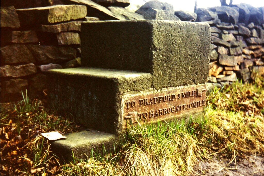
The cab fares were measured from the Market Cross, although in March 1890 the Fartown, Deighton and Bradley Sub‐Committee proposed that cab distances should be measured from the station instead of the Market Cross. The same Sub Committee had reported ʹthe necessity of revising the table of distances in connection with the hire of cabs in the Borough, more especially with reference to the Fartown Districtʹ. The Committee resolved that ʹthe Borough Surveyor should revise the cab distances for the whole Boroughʹ and this was duly carried out, as reflected in the little red pocket Borough of Huddersfield Year Book. The Cab Fares page showed charges were levelled on distances for a minimum 1 mile and for every succeeding half mile (or by quarter hours).

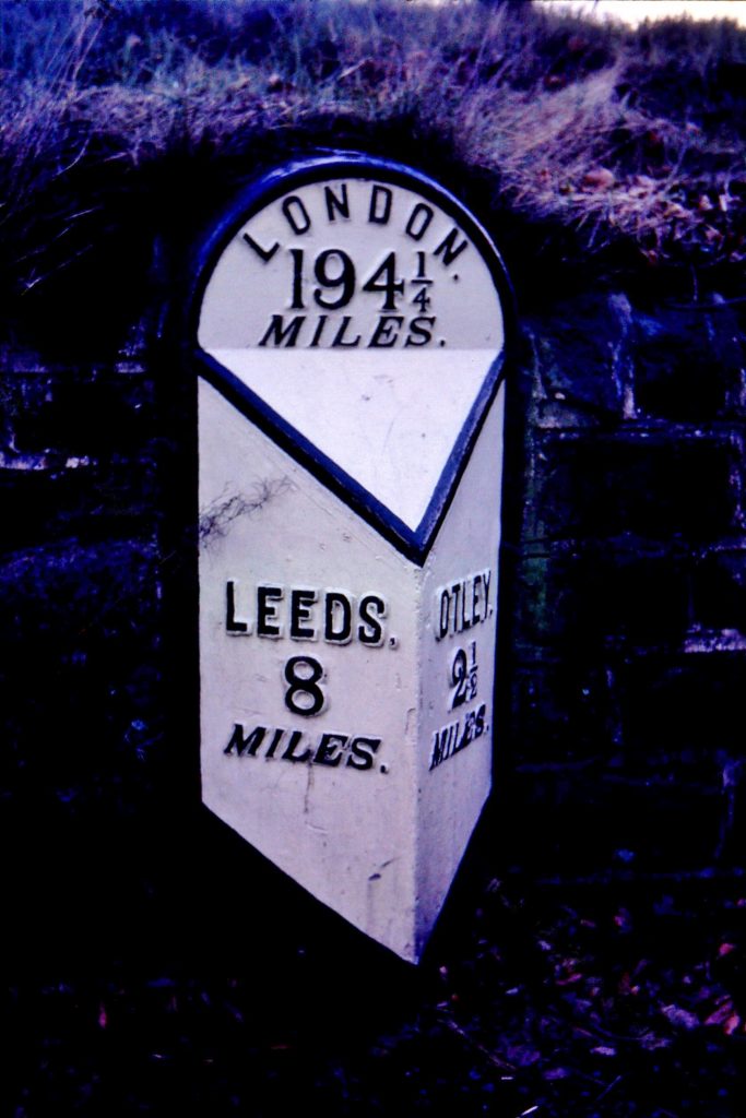
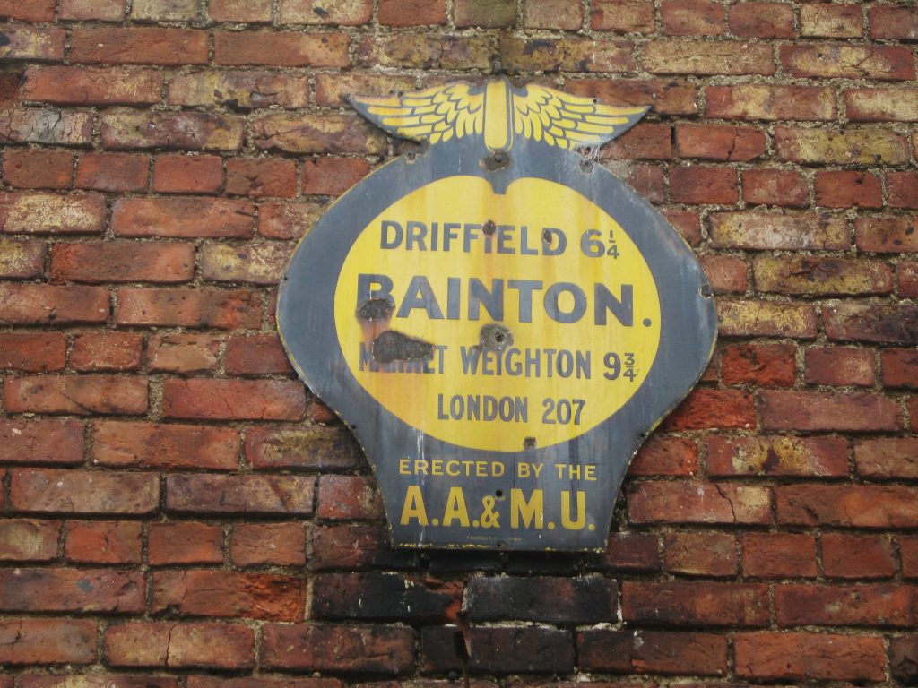
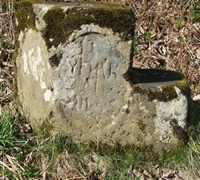
Huddersfield is unique in having triangular stone markers at half mile intervals on the roads within the borough, stating the distances to and from the Market Cross – these were the cab fare stages, although in the 1890 Year Book, all the datum points mentioned are chapels, toll bars, houses or junctions which suggests that the ʹTo & Fromʹ stones were not in situ in 1890. On the Bradford Road, the fare stage at ʹa mark on the wall 11 yards N of Mr Dewhirstʹs entrance gatesʹ was reviewed by the Borough Surveyor and moved a few yards northwards, against the shoeing forge (on the corner of modern Ashbrow Road – the bus fare stage is still known as The Smithy today); the distance from the Market Cross was 1½ miles and the fare was 1s 3d for a two‐wheeled cab, 1/6 for a four wheeler. The furthest distance recorded in the Year Book was to Thongsbridge Toll Bar, 5 miles 396 yards; no fare was specified.

Around the same time, there was a request for additional cabs on the stands at the railway station; such work was often ʹprivilegedʹ ie the cabmen paid a fee to the station. By 1894, the Light and Watch Committee was considering the Regulation of Traffic by the Railway Station; it was resolved that ʹarc electric lights should replace the two gas lamps by the Peel statueʹ and that horses were to face east.

A glance at the census returns for 1871 and 1881 reveals that many men were employed as coachmen or cab drivers with the occasional teamer; someone has pencilled ʹgroomʹ alongside many of these entries, perhaps an attempt at a generic enumeration. However, there is no indication whether the coachmen were in domestic, commercial or public service. Ostlers (also ʹgroomsʹ) would have been required at all the inns, theatres and other meeting places to take care of visitorsʹ horses or stagecoach horses.

One local family that became closely connected with the coaching, cab and livery trades in the 1880s was the Darwins. Thomas Darwin was born in Holmfirth in 1853, one of the six sons of James, a weaver who moved to Huddersfield around 1855 and was working as a Woollen Sorter. Most of the Fartown neighbours were employed in the woollen trades, including Thomasʹ older brother George H, although brother Frederick was a ʹlabourer on roadsʹ. Aged 18 at 1871 census, Thomas was employed as a butcher, living with his parents in Bradford Road. By 1881, Thomas was listed as a Master Butcher, living with the Bowtrey family at 121 Halifax Old Road; in October that year he married Elizabeth Ann Roberts of South Crosland at the Parish Church, Holmfirth.

With the granting of the operational licence in 1882, Huddersfield became the first municipality in Great Britain to construct and operate their own tramway system – such systems as existed elsewhere were privately run.

The first ten miles of Huddersfield Tramways track were laid down in 1882 and a steam engine drawing a car was given the first trial run on Chapel Hill in November that year; it was planned that the Paddock route would be operated by cable but this was abandoned. The first regular service was between the Red Lion Hotel, Lockwood and the Royal Hotel at Fartown (Toll) Bar, commencing in January 1883. In the first year of operation, the Corporation had six steam locomotives and the revenue was £1,277.

The fare from Lockwood to Fartown Bar was 2d inside, 1d on the top deck; the inside fare to the interim fare stage at Hebble Bridge (near the junction of Hillhouse Road with Bradford Road) was 1d. However, it was deemed too dangerous to operate steam trams in King Street, so from 1885 – 1888, the Moldgreen trams were pulled by horse traction (4). Similar consideration must have been given to the Fartown section because in the Huddersfield Town Council Minutes of 22 August 1885, the sub‐committee had decided that the Fartown Tram was to be run with horses; although they would undertake to confer with Mr Longbottom about his proposal in future, they accepted the tender of Mr Thomas Darwin of Fartown to work the route with horses. It was further decided that as soon as practicable the cars should be every quarter of an hour on that route.

That this actually operated is corroborated by a letter in an undated newspaper cutting (5) from Mr James H Earnshaw of 18 Springwood Street, stating ʹThe first horse tram to run in Huddersfield began to run to Moldgreen from September 1885 to March 1888. A few months after, two horse trams were run on the Fartown section, horsed by Mr Thomas Darwin and continued to November 1886. I was the tram driver on the Fartown section for the last three months of their running and William Cromack was the other driverʹ.

By 1897, the Corporation had a rolling stock of 26 steam locomotives and 26 double deck bogey cars; the revenue was £30,193. Conversion to an electric track system was begun in 1899 and completed in 1902.

Was it marriage that caused the young entrepreneur to branch out from butchery? Slaterʹs 1887 Huddersfield Directory lists him as a coach proprietor and cab owner, working from 158 Bradford Road North, the Miners Arms Beerhouse (now the Railway Inn) near Fartown Bar, then run by his mother Ann. Two dozen cab owners are listed, including older brother George H, who is also a postmaster at 27 Wasps Nest Road, and William Cromack.

By the 1891 edition of Slaterʹs, Thomas is building a successful business as a Livery Stable Keeper and coach/cab proprietor; his brothers are in associated roles, George H is a jobmaster (hiring out livery) as well as a postmaster, Frederick is a cab driver (though the census listed him as a Corporation yardman), John is a cab driver in Cross Grove Street, William is a teamer (a driver of a team of horses used for hauling) at 18A Upper Aspley and Thomas F (son of George H) is a cab driver living at Norman Road, Birkby.

Thomasʹ livery stables continue to prosper, in extensive premises on Flint Street called Fartown Mews, proudly engraved on his letterhead. He is often mentioned in the Chronicle, including for winning a four‐wheel competition or taking groups of ladies or children on pleasant outings – the children taken to Sunny Vale Gardens in 1893 were each presented with five tickets including for the boats, swings and automata. In the same year, the Chronicle notes, he provided stabling for the June Exhibition, the Grandest Programme of the Season: ʹAll the horses for this Night will be specially selected from the most WILD AND VICIOUS HORSES in this vicinity.ʹ

In 1894, he treated the yard stablemen and coachbuilders in his employ to a capital dinner at the Miners Arms, then run by his (less reputable) brother James. Note the reference to ʹcoachbuildersʹ rather than ʹcoachmenʹ so presumably he had an in‐house maintenance team.

Around this time, another revolution in transport was noisily beginning. The Germans (Daimler and Benz) had been producing motor cars since the 1880s although the French dominated the production of cars in Europe until 1933, when Britain took over (6). British‐built Daimlers (under licence) began in 1896, the same year that the Locomotives on Highways Act removed the strict rules on UK speed limits. The RAC was founded in 1897 and the Yorkshire Automobile Club in 1900, one of the strongest in the provinces by 1905, with 600 members (7).

The Rippon Brothers of Viaduct Street were coachbuilders; they did not actually claim descent from the eponymous coach builder to Elizabeth 1st, nor did they deny it. However, they did adhere to the very highest standards and they began coachbuilding bodies on various Continental automobile chassis, including Spyker; in 1906 they began a partnership with Rolls Royce, building bespoke bodywork to customersʹ orders. The early horseless carriages often resembled their antecedents, with the driver exposed at the front, as the coachman had been on the box.

Tram in Viaduct Street by Rippon Bros (kirkleesimages.org.uk)

The early adopters were often wealthy young men with an engineering bent, essential because the vehicles were most unreliable, needing repairs by the roadside and frequent changes of tyres or wheels as a result of punctures. However, as the vehicles became more reliable in the early 1900s and tyre technology improved, they were bought by private families to supplement the carriage. The driving skills required were not those of the horseman, more of the ʹstokerʹ, some vehicles being propelled by steam, hence the term ʹChauffeurʹ. The wealthy often imported a French or German driver with their cars. Older coachmen found it difficult to adapt and ʹHome, Jamesʹ by Lord Montagu of Beaulieu contains some amusing and insightful anecdotes. A young groom or male house‐servant might be delegated to learn how to operate and maintain the thing; there was no standard layout of the controls. A provider such as Rippons might give elementary instruction but after that, they were on their own, or at the mercy of one of the repair ʹgaragesʹ that sprang up, providing servicing as well as storage. Domestic accommodations for cars were known as ʹcar housesʹ (8).

The career of the live‐in young coachman employed in his declining years by Henry Dewhurst at Fartown Lodge provides an example. The 1901 census lists 26 year old Arthur Cockayne, who hailed from Swanwick, Belper, on the Derbyshire/Nottinghamshire borders. Live‐in domestic staff were not permitted to be married, but this did not apply to outdoor staff such as coachmen, for whom separate accommodation could be provided. Recruitment was either by recommendation or through advertisements in magazines or newspapers, both local and national; by the 1890s, most large towns had one or more servant registries (9) ‐ the Huddersfield Chronicle carried advertisements by the Lincoln Registry at Springwood Street, for ʹServants for Town and Countryʹ.
Servants frequently travelled long distances for work – employers often preferred staff with no local connections and therefore less likelihood of gossip in the neighbourhood.

After Henry Dewhurst died ʹof senile decayʹ in 1902, Arthur Cockayne married Margaret Allen from Durham at Huddersfield in December 1904 and went on to take advantage of that new development, the automobile. He moved to Middleton in Leeds where his daughter Beatrice Rosetta was born, then to York; by the 1911 census, aged 35, he was employed as a chauffeur, living in Walton Road, Wetherby. The chauffeur was a professional, falling outside the customary servant hierarchy, as had the governess; he was often in close contact with the mistress of the house and scandalous indiscretions occasionally resulted.

Little formal instruction was available and driving licences were not implemented until 1910. In that year, doctorʹs son Stanley Roberts realised that motoring was going to be big business and set up his own driving school, naming it The British School of Motoring, now known simply as BSM. Previously an engineerʹs apprentice with Thomas Sopwith, Roberts was a motoring fanatic and persuaded his parents to rent out their garage at 65 Peckham Rye to his fledgling business and to house his prized possession, a Dutch‐built Spyker. Offering a ʹPopular Course of Mechanism and Drivingʹ, Robertsʹ first pupil was a former coachman, whom he trained to become a chauffeur; the business expanded nationwide.

Thomas Darwin also kept abreast of the new developments in the twentieth century as owner‐drivers enthusiastically embraced the automobile, catering for both those who drove and those who did not. He is generally listed as a cab proprietor in the trades directories, but also as a funeral director; his 1906 letter‐head notes that he offers the ʹNew Silent Tyred Funeral Carsʹ. The history of hauliers Joseph Hanson & Sons of Milnsbridge records that ʹIn 1920, Thomas Darwens, wedding and funeral car hire, was acquired. Some 8 years later the old cars were replaced with Rolls Royces and the limousine service continued for 50 years.ʹ Thomas became a major shareholder in the Yorkshire Motor Car Co, of Elland Road, Brighouse, calling in his debenture in 1922 and later was appointed a receiver for the business.

His own operations were now managed by his nephews James Henry Heaton Darwin and Norman Darwin, sons of George H, the jobmaster and postmaster; Norman ran the site at Flint Street trading as Fartown Garage, also funeral directors, supplying motor hearses, landaulettes, horse carriages &c, while James H H, his family and his younger brother John Edward were operating out of Fartown Lodge Mews, the former home of Arthur Cockayne the coachman, described as Fartown Lodge Garage in the Halifax & Huddersfield District Trades Directory (10).

Thomasʹ draft will in 1926 bequeathed ʹall stock in trade, horses, carriages, harness and other effects … as a Carriage Proprietorʹ to his nephew James H H, and ʹthe motor hearse and cars as a Garage Proprietor in Flint Streetʹ to his nephew Norman. Thomas died in 1938, the year that Norman is listed as a Director of the newly incorporated Silver Wheels (Hire) Ltd. James H H had an ironic end at the age of 57; in 1930 his daughter wrote to Thomas in great distress from Vancouver, reporting that he had been knocked down by a car and killed (11).

The Darwinsʹ connection with the coachmanʹs house continued until the 1950s; in the early 1930s, it was bought by another cab proprietor, Walter Vosper Holder Halstead, whose sister Beatrice then married James HHʹs son Stanley; they all lived together in the coachmanʹs house and continued to run old‐fashioned cars as taxis, perhaps those sold off by Hansons. After Walterʹs death in 1953, Beatrice and Stanley moved out, and the property was bought by another member of the motor trade, Olaf Olsen the Volvo dealer. He had completed his coachwork apprenticeship at Rippon Bros and apparently had painted the coachlines on two of the Rolls Royces supplied to Beaulieu, presumably to be driven by Lord Montagueʹs chauffeurs, although the Volvo was fast gaining a reputation for outstanding reliability, too!

Jan Scrine, © The Milestone Society, 2020

References
1,2 Trevor May: Victorian and Edwardian Horse Cabs; Shire Publications, Oxford, 2009
3 Huddersfield Corporation Light and Watch Committee Minutes, May 1890
4 The Huddersfield Examiner, 26/7/1952, 70th Anniversary Supplement
5 Huddersfield Local History Reference Library, ʹTramsʹ file
6,8 Kathryn A Morrison and John Minnis: Carscapes: the Motor Car, Architecture and Landscape in England; English Heritage, 2012
7 Motoring Annual 1907, quoted in Jonathan Wood: Rippon Brothers, a Coachbuilder of Renown; 2012
9 Trevor May: The Victorian Domestic Servant; Shire Publications, Oxford, 2009
10 Halifax & Huddersfield District Trades Directory 1925 – 1926, p 121
11 West Yorkshire Archives, Darwin files.

This article was originally published in MILESTONES & WAYMARKERS, 2020, vol 12.

Travelling around Huddersfield 1880-1920 Read More »

Cleckheaton fingerposts

Cleckheaton residents can now once again enjoy a local landmark in its original glory, the 80-odd-year-old fingerpost outside the Fire Station – at the junction of Westgate and Hightown Road. (We refer to it as a fingerpost, though no fingers are to be seen on it).

Hightown, in the parish of Liversedge to the south of Cleckheaton, was in the 19th century a straggling collection of small settlements along the Wakefield to Halifax Turnpike, from Hightown Heights down to Middle Gate. Its main claim to fame was as, briefly, the residence of Patrick Brontë, assistant curate at nearby Hartshead Church (since restored to its original Norman glory), prior to his move to Thornton, the birth of his famous children, and his final settlement in Haworth. It has grown since then, and now includes the Windybank Estate, built after the Second World War, with its imaginatively-named streets – First Avenue, Second Avenue, and so on up to Thirteenth Avenue. Unlike their American namesakes, however, their numbering does not reflect the layout. But I digress.

Hightown Road was built sometime between 1922 and 1934, according to the dates when it appears on Ordnance Survey maps – perhaps as a belated by-product of the creation of the Spenborough Urban District in 1915.

The signpost was probably erected at the same time, directing along the main road, Westgate, now the A643, to Birstall, Leeds and Bradford to the east, and Brighouse, Elland and Huddersfield to the west. The new road, up to Hightown, directs the motorist not to Hightown, but again to Huddersfield – same distance, 7½ miles, but a more convoluted route. When he (because it probably was a he) reached Hightown, to cross the present A649, the motorist will have been directed onwards by another signpost of similar date and design.This image has an empty alt attribute; its file name is Cleckeaton-IMG_8649-1024x768.jpg

Both finger-posts were made by the Royal Label Factory of Stratford-on-Avon.  This company, as its name implies, had been established in 1874 and made labels for the gardens of Queen Victoria’s estate at Sandringham in Norfolk.  From other labels of all types for less royal customers they were making finger-posts and other signposts for local authorities from the 1930s onwards.  It is said to have produced half the finger-posts in the country.  As part of Leander Architectural, but now in Buxton, they still produce street furniture and signs of all kinds, and have been involved in the restoration of heritage signs.

The Spen Valley Civic Society restored the latter in 2003, and then decided in 2016 to restore the one at the bottom, on the A643. Over the years, unloved, un-noticed and uncared-for, it had lost two of its arms and become a rusty relic. Thanks to a grant from Kirklees Council’s You and Your Community funding programme, volunteers were able to work on its restoration: new metal letters were made to match the originals, brackets were manufactured using the one remaining original as a pattern, wooden finger-boards were created, and the metal post was stripped of rust and repainted with numerous coats of paint.

The restored signpost was unveiled in April 2017 by Jan Scrine, and the finished result is inspirational – even for those of us who are not inspired by finger-posts.

Sources: Milestone Society Newsletter, no 33, August 2017; Graces Guide to British Industrial History (www.gracesguide.co.uk); www.leanderarchitectural.co.uk; not forgetting Wikipedia.

RWH /Feb 2019

Cleckheaton fingerposts Read More »

Guide-stones around Skipton: the ‘Craven stoops’

Around the Skipton area are over 20 small triangular stones, mostly painted white with black lettering, most with a pyramidal top, and found mostly at minor road junctions. Village names, sometimes with arrows or crude hands painted on them, direct the traveller along the lanes.

They can be found throughout the Craven District – in Bolton Abbey, Coniston Cold, Cracoe, Draughton, Eshton, Gargrave, Linton, Stirton-with-Thorlby, Thorpe and Threshfield.

A typical example, YN_XXSGCT, illustrated here, is on the B6265, about a mile north of the Skipton northern by-pass. It is at the junction of Bog Lane (an indication, perhaps, of its formerly uninviting condition) with the B6265, just before the oddly-named None-Go-Bye Farm. The narrow Bog Lane leads directly to Stirton, and thence to Gargrave – as indicated on the left-hand side of the stone. The right-hand side shows directions to Cracoe and Threshfield (though these destinations are incomplete, perhaps following an altercation with a road vehicle).

There is, however, no indication that the main road leads back to Skipton, suggesting that whoever erected it assumes this is the direction you have come from – though if this was the case and you really wanted to go to Stirton or Gargrave you wouldn’t have come this way.

The stones are stylistically quite different from those erected in response to the demands of the County Justices at the turn of the 18th century: those were aimed at travellers on featureless moorlands. And since there are so many of them in a very similar style they are unlikely to be the work of different parishes.

They were in fact erected in the second half of the 19th century: this stone (like many of the others) appears on the 1896 Ordnance Survey map, but not on the 1853 edition.  And they were put up by the East Staincliffe Highway District (ESHD). This was one of many Highway Districts created in the 1860s, taking over the functions of parishes (who thus gave up their highways responsibilities) and, later, the failing Turnpike Trusts. They were abolished following the creation of Rural District Councils in 1894.  The East Staincliffe Highway District, named from the ancient wapentake of the same name, also erected a number of boundary stones in the area; these are marked E S H D.

RWH / Feb 2019

Guide-stones around Skipton: the ‘Craven stoops’ Read More »

Mounting-block milestones

The most common type of milestone is what we call the “tombstone” type, a thick stone pillar well embedded in the ground with mileages carved or painted, or with a cast-iron plate screwed onto it.

Occasionally, however, a different type is found, the horse mounting-block, or horsing-stone.  They combine the directions and mileages of the traditional milestone in a (usually) three-stepped stone to enable travellers to get on or off a horse easily. 

Quite why anyone should need to do this at a milestone is not clear.  It does, however, indicate that many travellers were on horse-back.

Mounting-block milestones survive in all three Yorkshire Ridings.

The only road entirely in the North Riding to have them was the York-Oswaldkirk turnpike.  In 1772 the trustees ordered that milestones be erected “in the form as follows: wood mile post 4½ feet in length; every third mile a horsing stone”.  Four of these are still in position.  Others can be seen on roads leading into the east Riding.

In the West Riding there are half-a-dozen on the road between Bradford and Harrogate.  These have (or in most cases had) a cast-iron plate giving destinations and distances.  One, at Pool, retains its plate – illustrated here.

Another six survive on the original turnpike between Leeds and Otley, dating from the middle of the 18th century.  This road is now an unclassified road leading more directly and steeply from Otley and was replaced by the present A660 in 1842.  With destinations carved on the front and side, most are now badly weathered.

It is in the East Riding, however, that most can be found: in fact over 50 of the 108 milestones recorded by the Milestone Society are of the mounting-block type  – a feature unique in its frequency in the country.

The roads with mounting-block milestones include Beverley-Hornsea, Hull-Beverley, Hull-Hedon, Hull-South Cave, York-Beverley and York-Driffield.  Many have deteriorated from weathering, or suffered damage from grass-cutting, or traffic accidents, and many have lost their plates, but the County Council and Milestone Society members have been actively renovating them as time and resources permit. 

Click here for more information on the East Riding milestones.

Outside Yorkshire there is an interesting series of “horsing-stones” on the old Great North Road in Lincolnshire. The 4th edition of Paterson’s Roads of 1788 notes: ‘From Stilton to Grantham, at every Mile are Blocks, made of the famous Ketton Stone, with three Steps, which were placed there by a Mr. Boulter, for the easy mounting of his Horse, he being a very corpulent Man, and travelled that road every Week for many Years; each Stone engraved E.B. 1708.’ Milestone Society members have been researching these “Boulter stones” and their latest findings can be found on the Milestone Society website.

RWH / revised Jan 2022

Mounting-block milestones Read More »

Milestones on the York to Oswaldkirk Turnpike

Oswaldkirk is a village 20 miles north of York and four miles south of Helmsley in North Yorkshire. It is named after St Oswald (died 642), Anglo-Saxon king of Northumbria.

The turnpike was established by Act of Parliament in 1768 and followed the line of the present B1363. At Oswaldkirk the turnpike joined the present B1257, which with the A170 connected it with Helmsley. It thus provided a more direct connection to that area.

The milestones on this road are interesting, as every third stone is a so-called ‘horsing-stone’ – a tall block with steps to enable easy mounting of a horse. The minutes of the Turnpike Trust include the following details.

In 1772 ‘. . . milestones were to be erected … in the form as follows: wood mile post 4 feet in length; every third mile a horsing stone; … ‘. Later, in 1776 it was ordered ‘… that the mile posts be painted dark blue, with white letters and figures, old Roman capital letters and figures ‘. At a meeting at the (still there) White Bear in Stillington in 1789, it was ordered ‘. . . that the mile stones be repaired if necessary and that the letters or figures thereon be fresh painted’.

In 1814 it was ordered ‘that mileposts be erected at the end of each mile where the present stones are decayed and defaced, and that the first mile from York be measured from Bootham Bar, or such other place as the distance has commenced, and be so expressed upon the first mile post‘.

The Milestone Society has records of four surviving horsing-stones (or mounting-blocks) on this road. They are, from south to north:

At Wigginton, ¾ mile north of the A1237 York ring-road, on the west side of the road (and usually almost hidden in the grass), opposite the entrance to Villa Farm – three miles from York.

On the west side of the road north of Sutton-on-the-Forest, nearly opposite Low Inhams Farm, south of Moxby Lane, about half way between Sutton and Stillington – nine miles from York.

At Gilling East, just north of the cross-roads – 18 miles from York.

Between Oswaldkirk and Sproxton, about one mile south of Sproxton on the now B1257, on verge opposite the entrance to Golden Square Farm – 21 miles from York. Curiously, this appears to be beyond the remit of the Turnpike Trust, which ended where it met the Helmsley/Thirsk-Malton road at Oswaldkirk Bank Top. (Illustrated on right)

Those six, 12 and 15 miles from York have not been found.

Sources: Jennifer Perry: York-Oswaldkirk Turnpike Trust 1768-1881 (North Yorkshire County Record Office, 1977) and Milestone Society records.

See also the article on mounting-block milestones in the East Riding and elsewhere.

RWH / Jan 2019

Milestones on the York to Oswaldkirk Turnpike Read More »