Uncategorised

Late 19th century milestones in the North Riding

Late 19th century milestones in the North Riding

The North Riding has many milestones surviving from the turnpike age, some the original 18th century ones. Some, however, were replaced later in the 19th century, such as these two here. On the left one at Breckonborough, between Northallerton and Boroughbridge on the Boroughbridge, Darlington and Durham Turnpike (now the A167); on the right one a mile north of Thirsk on the B1448, erected by the Thirsk Turnpike Trust on a road that led from Northallerton to York. Both give distances to London. Although not too dissimilar in style from later milestones the foundry that produced them is not known.

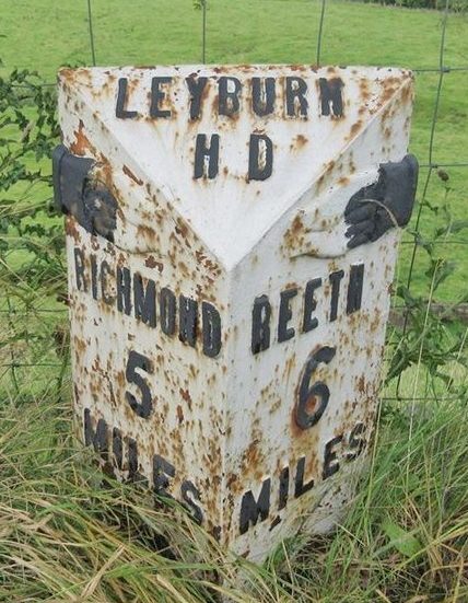
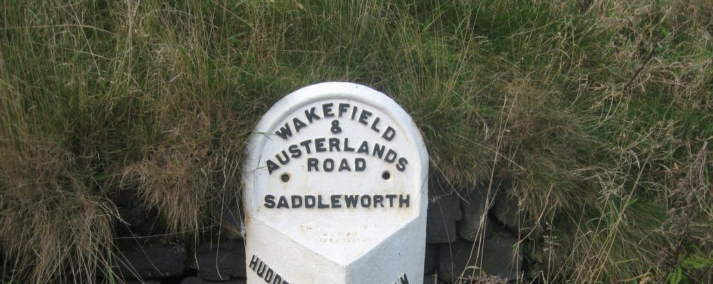
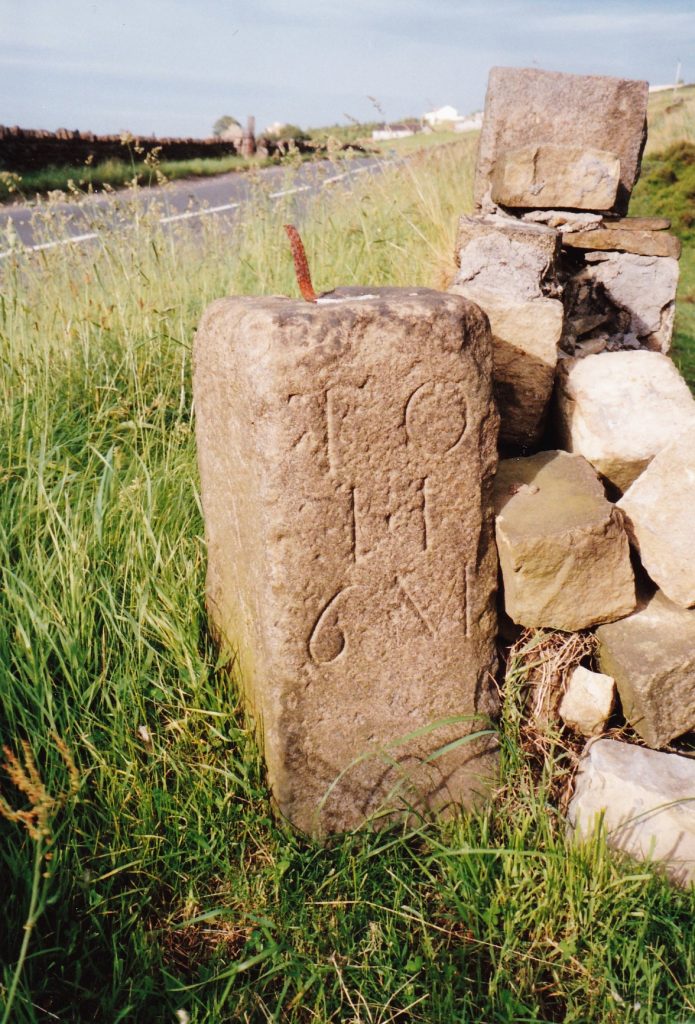
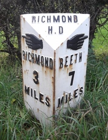
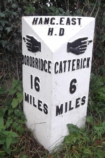
Later in the century (following the 1862 Highways Act) Highway Boards were established, to take over from failing/failed turnpike trusts. Some of these erected new milestones, with pointing fingers and the name of the Highway District (H D).

At the October 1867 “Gene Quarter Sessions of the Peace” for the North Riding the Justices made the final order for dividing the county into highway districts.  This excluded those Boroughs and Urban Districts which were already responsible for their roads.  There were 16 districts, details published in the London Gazette, each named with all the parishes and townships they comprised

Among them were:

Askrigg District, covering Upper Wensleydale;

Leyburn District, covering mainly Lower Wensleydale;

Richmond District, covering Swaledale and an area east of Richmond up to the Tees;

East Hang District, covering the area around Bedale and south to the West Riding boundary.

The East Hang District was named after the East Hang Wapentake (originally just the Hang Wapentake but divided in the 13th century into East and West).  This gets its name from the wapentake meeting-place at Hang Bank, between Hutton Hang and Finghall.  Hang West covered all Wensleydale and so was not a Highway District.

Here are some of their milestones.

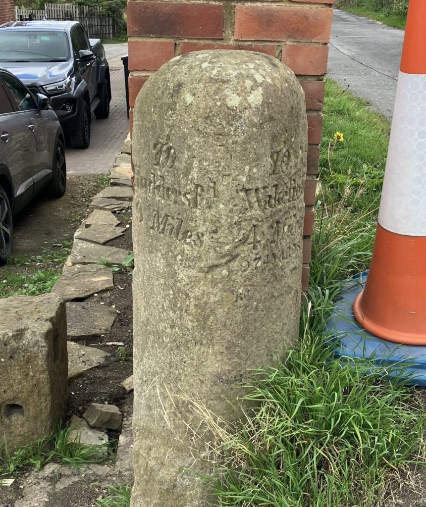
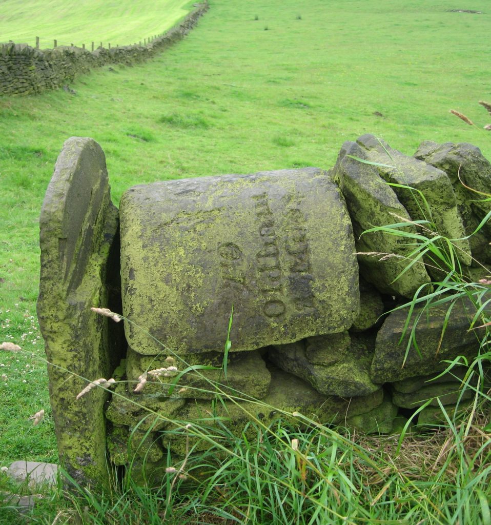
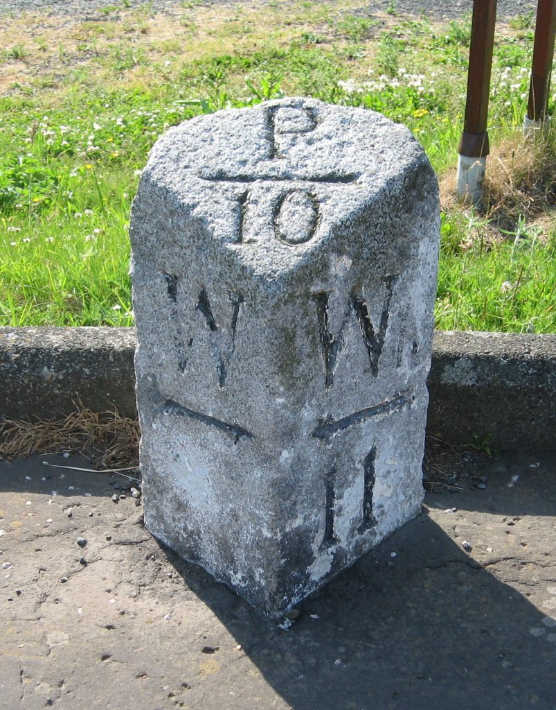
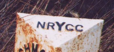
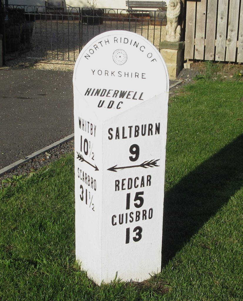
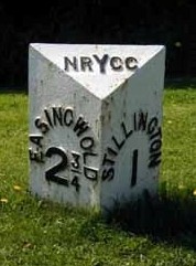
The North Riding County Council was established in 1889, and took over the functions of the Highway Boards.  At some point it set about replacing older turnpike milestones with new ones.  There were two types, both usually made by the Mattison foundry at Leeming: the first, quite elaborate, with a stylised Yorkshire rose and the name of the district where it was; the second, possibly later and definitely cheaper, merely has the letters NRYCC.  The examples below are from Hinderwell and Stillington, near Easingwold.

.

.

.

.

.

.

.

.

Sources: Article by Christine Minto in the Milestone Society Newsletter, no 22, Jan 2012, pp 34-5; London Gazette, 29 October 1867, p 5725

RWH / Sept 2025

Late 19th century milestones in the North Riding Read More »

The Wakefield and Austerlands Turnpikes

The Brayshaw & Booth milestones in the Colne Valley west of Huddersfield have tended to cause confusion: where is Austerlands?  And why Wakefield? 

Austerlands is a blink-and-you-miss-it place on the A62 in Saddleworth, right on the border with what was Lancashire.  The turnpike was planned to connect this part of the West Riding with Manchester, the Lancashire section having already been turnpiked, in 1735.  From Huddersfield there was already a road to Leeds, so a link eastwards to Wakefield was deemed desirable.  There were three turnpikes, whose routes differed in varying degrees, dating from 1758, 1788 and 1820, the last one being basically the same as the present main roads between Wakefield and Oldham.  The trust was wound up in 1882 and responsibility for the road reverted to the district councils along it.

This article covers the main features of the roads; a more detailed article is to follow.  The milestones on the present road are of course all those erected by the West Riding County Council in the 1890s (detail illustrated at top), but others exist elsewhere on the route.

Part one: Wakefield to Huddersfield.

The earlier turnpikes had two divergences from the A642: the section between Horbury Bridge and the present Mining Museum ran south of the present road; and the original route went through Lepton to Almondbury before going down into Huddersfield.  An old toll-house exists at Horbury Bridge (though now called The Cottage), and another on Rowley Lane going down through Lepton, an attractive little building which has survived for over 200 years despite its redundancy.

Horbury Bridge toll-house
Lepton toll-house

.

.

.

.

.

.

The out-of-place Middlestown milestone

Most interesting, though nowhere near its original location, is a milestone from perhaps the second turnpike which can be found near Middlestown.  It marks nine miles from Huddersfield and four miles and (what one presumes is a later addition) 794 yards from Wakefield.  It can be found by the side of a brick wall on Low Lane.  We have no idea when or why this came to be here but it is well-preserved and likely to remain so.

Part two: Huddersfield to Standedge.

The first two turnpikes went up to Crosland Moor and Blackmoorfoot before descending into Marsden.  And from Marsden they took separate routes up to the watershed at Standedge and over the moors.

Old milestone on Chain Road, Marsden

Two milestones can be found on the old stretch up to Marsden, three and six miles from Huddersfield.  They are plainer than the one at Middlestown; the latter, slightly better preserved of the two, on Chain Road (itself a relic of the turnpike days) says simply “TO / A / 9M” and “TO / H / 6M”.  They possibly date from the first turnpike but we cannot be certain.

Interesting features above Marsden include a boundary stone where the road passed from Marsden-in-Almondbury township into Marsden-in-Huddersfield.  This reads “M+H / 720 / Yard”; it is thought that this distance represents the length of the road before it enters Saddleworth.  Where Mount Road and Old Mount Road meet a section of the second turnpike crossing a stream was demolished to avoid people trying to avoid taking a free alternative route; this is still visible.

.

.

Remains of the milestone near Delph

Part three: Standedge to Austerlands.

Saddleworth was therefore entered by three routes which met for a brief stretch before Delph but then took different routes again before reaching Austerlands.

Three milestones (or two and a bit to be more exact) survive from the earlier turnpikes in the same design as the Middlestown stone.  Part of one exists, incorporated onto the top of a wall, near Delph.  The no longer entirely legible destinations once read Huddersfield 13 miles and Oldham 4½.  Another, marking 12 miles from both Huddersfield and Manchester, is complete and still in its original position just above Delph.  And a third is in the museum in Uppermill.

Sources include Crump: Huddersfield highways down the ages (Tolson Museum, 1949) and Bodey: Roads (Batsford, 1971).

RWH / Sept 2025

The Wakefield and Austerlands Turnpikes Read More »

The medieval bar stones of Leeds

Leeds became a borough with a charter from Charles I in 1626, although it had been developing into a town after an earlier charter from King John in 1207.  Small and compact, it grew in importance from its location by the bridge over the Aire, which had probably been in existence since at least Norman times. 

In the Middle Ages anyone wanting to enter it to trade would have to go through the so-called “bars”.  Unlike York, for example, with its elaborate bars (Micklegate Bar, etc), Leeds wasn’t fortified.  Its checkpoints were buildings, probably wooden, on the main roads.   John Cossins’ Plan of Leeds published in 1726 suggests that by then the bars were wooden gates designed to keep out stray cattle, delay unwanted visitors, and collect tolls on market days.  As time went on the checkpoints were removed and replaced by a stone to show, in effect, the boundaries of the town.

­There were six of these, of uncertain date.  Three of them survive, and all but one are marked by Leeds Civic Trust blue plaques.  Clockwise, from the north, they are:

The North Bar: on the front of the old bus station, now a café, on Vicar Lane.  Click here for picture.

The East or York Bar: on the wall in front of the Parish Church of St Peter on Kirkgate.  Click here for picture.

The South Bar: on the south side of Leeds Bridge at the bottom of Lower Briggate.  A Civic Trust plaque marks the spot.

Burley Bar: a blue plaque on the Headrow marks the location of this; the actual stone is now inside the main entrance of the Leeds (formerly Leeds & Holbeck) Building Society, also on the Headrow (corner of Albion St).  Picture to follow.

The West Bar: a blue plaque, unveiled in 1989, is the only record of this: at the Bond Street Centre outside 34-38 Boar Lane.  The western border of mediaeval Leeds was adjacent to the Manorial Park.

Woodhouse Bar: where Dortmund Square is now.

Sources: https://www.secretleeds.com; https://leedscivictrust.org.uk/the-north-bar-plaque-a-medieval-gateway-to-leeds/; Wikipedia

RWH / July 2025

The medieval bar stones of Leeds Read More »

Milestones on the Richmond to Lancaster road

The Richmond to Lancaster turnpike was opened in the middle of the 18th century to provide an east-west coast-to-coast transport route across the north of England.  At Richmond (or more specifically Catterick Bridge in nearby Brompton-on-Swale) it would connect with the Catterick Bridge to Durham turnpike (opened in 1747): this went through Yarm, on the River Tees, a busy port at the time.  At the other end Lancaster too was a rapidly growing port on the Lune.  It had trade with Ireland, North America and the West Indies, while Yarm gave access to the Baltic, the Netherlands and France.  At Brompton-on-Swale it also joined the Great North Road.

On the bridge at Richmond

The act was passed in 1751, though the road was not completed until 1774.  It was based mainly on existing roads which were, in the words of the original petition, “bad, ruinous, narrow and rocky … impassable at some times of the year … [and] dangerous”.

The route, from Richmond on the Swale, went down into Wensleydale where it went along the north side of the valley to Askrigg, then the major settlement in the upper dale.  (Nowadays the main road is south of the river, the A684).  From there it originally followed the old Roman road through Bainbridge (site of a Roman fort) and over to Gearstones, just before Ribblehead.  In 1794, however, this problematic stretch was replaced by a lower route through Hawes and up Widdale.  This was beneficial for Hawes which began to overtake Askrigg as the more important settlement.

Turnpike stone near Hawes

At the head of Widdale (on the new route) and at the high point of the old Roman road, the turnpike left the North Riding and entered the West Riding.  Still following the Roman road as far as Ingleton, it then entered Lancashire a mile or so west of Burton in Lonsdale.  There was, however, an alternative proposed route from Ingleton; this went south of the Greta through Wennington to serve some local coal pits.  These two routes met near Farleton, about 8 miles from Lancaster.

Milestones

County boundary stone

On the North Riding stretch five of the original turnpike milestones survive: at Redmire, Woodhall, on the western edge of Hawes, halfway up Widdale, and at Widdale Head just before the county boundary.  Sadly, all the old turnpike milestones are in a poor condition, and virtually nothing is legible on any of them: some have numbers on them with possibly an L or an R for the destinations.  There is also a plaque on the bridge over the Swale on the western outskirts of Richmond, stating “To Askrigg 18 / To Lancaster 56 / Miles”.  This is of uncertain date, possibly late 18th century.

At the county boundary an interesting stone can be found.  At the bottom is the name Ingleton Township so it was presumably they who erected it as there is no mention of Hawes on the North Riding side.  Although it now reads simply North Yorkshire on the right-hand side the word Riding was presumably there originally.

West Riding C C milestone

Probably shortly after its creation in the late 19th century the North Riding County Council erected milestones on many of the major roads in the county.  By this time the old turnpike had lost its importance and was not included; instead the Council put milestones on the dale’s southern road, now the A684.  Most of these survive.

None of the original turnpike milestones exist on the West Riding stretch of the road.  The newly-formed County Council had a programme to replace old turnpike milestones with new ones on many roads in the county (click here for details of this), and although this road was not included in the original contract it is assumed these were part of a later as yet untraced scheme.  Most of these (ten in all) are still in situ.  Designed in the same style as the so-called Brayshaw and Booth stones, they were actually produced at William Towler’s Globe Foundry in Leeds.

Lancashire C C milestone

Lancashire County Council had a similar programme of replacing old turnpike milestones with new ones to a standard design, and several remain on their side of the boundary.  They give mileages only as far as Ingleton, as well as to other places in Lancashire and Westmorland where the road leads.  There is in fact just one survivor of the original turnpike stones, on the now A683 west of Caton, marking three miles to Lancaster.

Source: article by Hilary Jones in Milestones & Waymarkers, 2024, vol 16, pp 10-19.  The illustrations are Milestone Society photographs on geograph.org.uk.

RWH / July 2025

Milestones on the Richmond to Lancaster road Read More »

Dumb steeples – boundary markers?

In the Huddersfield area there are two structures (they are hardly buildings) known as “dumb steeples”.  That is to say they are steeple-like obelisks, but without bells.  As far as I can trace they are unique in the country for being so called.  One is well-known, the other less so.

The well-known one is at Cooper Bridge where the road east from Brighouse (the A644) meets the Huddersfield-Leeds road (the A62) – well-known as it is passed daily by thousands of vehicles at the very busy roundabout.  In fact it originally stood in the centre of the road junction but was moved to the side of the road as traffic increased.  It is famous also as a meeting-point of the Luddites prior to the attack on Rawfolds Mill in 1812.

Nothing is really known about this obelisk (as it is called on the earliest OS map of 1854) or when the term “dumb steeple” was first used; Frank Peel in his Risings of the Luddites of 1880 calls it that.  Many, however, are the theories of its origins and purpose, summarised in an excerpt from one of the Minters’ books on old Huddersfield and reproduced on the Huddersfield Exposed website.  

The explanation we like is that it was a boundary marker, possibly relating to the nearby Kirklees Priory and Estate; or possibly from its location at the junction of the townships of Clifton, Hartshead and Mirfield.  Similar obelisks, eg at Ackworth, were in effect guide-stones giving destinations and distances, but there is no evidence of that here.

The other dumb steeple (pictured right) is at Grange Moor in the township of Whitley Upper, and this is not well-known as it is surrounded by modern houses at some distance, and not visible, from the quiet country lane leading to Briestfield.  Again, nothing is known about the origins of this.  A plaque (detail top) in the centre says it was rebuilt by Richard H Beaumont Esq in 1766, but with no clue as to why, or when it was first built.  A member of the family who owned the Whitley Estate, born in 1748, he was therefore only about 18 when he rebuilt it – perhaps it was to give him something to do.  It may well have been a boundary marker between the Whitley Beaumont estate and that of a branch of the Kaye family at Grange (that is Denby Grange, a hamlet in Whitley Upper township).  [Source W Y Archaeology Service]

RWH / June 2025

Dumb steeples – boundary markers? Read More »

Conservation of milestones and waymarkers

How not to restore a milestone

Some Milestone Society members are active in encouraging the local authorities who are responsible for the maintenance of milestones to look after them properly – and some are involved in projects to conserve or repair milestones.

Examples of some local projects are given in the articles listed below.

The conservation of milestones is not straightforward: a simple coat of standard household paint may look nice for a little while, but can do more harm than good in the long term.

Accordingly the Society has developed a number of guidelines for local authorities and others, covering all aspects of conservation.  Click here for the Conservation Guidance section of the Milestone Society website.

Replacing a lost Brayshaw & Booth milestone

The Kirklees milestones restoration project

RWH / March 2012

Conservation of milestones and waymarkers Read More »

Northern Spring Meeting, April 2025

A lovely sunny day greeted the Society members who came to the meeting at Gargrave: a good day with very interesting speakers and lots of questions/involvement from the audience.

The guest speaker was Jenny Hill, Lead Curator at the award-winning Craven Museum in Skipton: “Behind the Scenes at Craven Museum – how do we look after a collection of 60,000 objects?” The museum was currently holding an exhibition on milestones, arranged in conjunction with the Society.

This was followed by three presentations:

“Milestone restoration around Port William” by Scottish member Jacqueline Crowther; known locally in her Dumfries and Galloway home as the “milestone fairy”, her good works include ensuring that her milestones continue to be visible after ger initial intervention. The photo shows a typically unhelpful milestone marking 10 miles to Port William (P) and two arrows to W places: Wigtown and Whithorn.

“Why do milestones have benchmarks?” by Rob Westlake, Milestone Society Chairman and a former surveyor with the Ordnance Survey; some milestones have not just one, but sometimes two or even three. They were obviously useful in more than just one way.

“Milestones on the Manchester, Bolton & Bury Canal” by Dr Paul Hindle, author and retired university Senior Lecturer in Geography. He provided before and after photographs of this much redeveloped area.

The afternoon was mainly a discussion session on “Hunting milestones”, preceded by Dr Hindle on “Using historic maps for research” and Hilary Jones, Society vice-chair on “The challenges of finding milestones on site”.

RWH / April 2025

Northern Spring Meeting, April 2025 Read More »

Recovery of an 18th century milestone from Barkston Ash, and now in Tadcaster

In April 2023 the Society’s Honorary Secretary received an email from a member of the public of an old milestone advertised for sale at £250 on Facebook Marketplace.  Visible on the photo was YORK and TAD 5.  It had obviously originated in the West Riding of Yorkshire. 

The seller was contacted by Hilary Jones, the North Yorkshire contact, and he turned out to be a groundworks contractor based near Otley.  He had recently acquired it from a farmer at Towton (the site of a notorious battle in the Wars of the Roses).  The farmer had found the milestone in one of his fields at Barkston Ash when it was hit by his plough “over 30 years ago”. 

On one face it read YORK 14 / TAD 5 and on the other, damaged, face R 7.  This would originally have been FER for Ferrybridge.  Research on the 1849 OS 6 inch map showed it was originally situated on the east side of what is now the A162, originally the Doncaster and Tadcaster Trust Turnpike, south of Barkston Ash, at SE 48997 35535. The dimensions and shape of the milestone are consistent with the 18th century in situ Grade 2 listed milestone (YN_DNTC18a) further south on the A162 at Betteras Hill https://historicengland.org.uk/listing/the-list/list-entry/1167565

The 1892 map shows it still in place but by 1908 it has disappeared from the map and a new milestone is shown south of the railway, where it still stands, one of the West Riding County Council’s so-called Brayshaw & Booth milestones (YN_DNTC22). 

It was agreed that the best home for the milestone (if we could acquire it) would be at a museum rather than at the roadside given it had been missing for over 100 years.  Christine Minto suggested The Ark.  This is one of the oldest buildings in Tadcaster, a former museum and now the home of the Tadcaster Town Council.  There are a number of old guidestones displayed in the rear yard of the premises.  The Town Council were contacted and at their August meeting agreed to accept the milestone for safe keeping at The Ark.

Fortunately the milestone was still unsold, and the vendor reluctantly accepted a reduced offer of £75 for it (it having been already reduced from £250 to £150).  The heavy milestone then had to be collected, delivered into temporary storage in Tadcaster (at the local brewery) in September, and finally moved into the yard at The Ark on 23rd November 2023.  The cost for the installation work (£150) was shared 50/50 between the Town Council and The Milestone Society.

There are now 12 recorded out of place guidestones and milestones on display at The Ark and near Tadcaster, and the Tadcaster Historical Society are going to work with us to produce an information leaflet covering them all.  This one now has the milestone ID YN_XTADl (lower case L).

Source: article by Hilary Jones in the Milestone Society Newsletter, no 46, winter 2024.

RWH / March 2025

Recovery of an 18th century milestone from Barkston Ash, and now in Tadcaster Read More »

Northern Spring Meeting 2024

Another interesting day in Gargrave on the edge of the scenic Yorkshire Dales.

The Programme included David Garside on Waymarkers along the Pennine Way in North Yorkshire (David walked the Pennine Way in 2015); Hilary Jones with A tale of two turnpikes: milestone restoration on the A6 north of Preston; and Terry Moore on Signpost restoration in Cumberland.

There was also an opportunity for anyone who would prefer a walk in the afternoon with a self-guided leaflet highlighting the variety of local waymarkers in Gargrave.

Northern Spring Meeting 2024 Read More »

Uppermill Local Board and its boundary stones

­­­The Saddleworth district of the West Riding was traditionally divided into four meres, each further divided into two or three divisions, commonly called upper, middle and lower.  See www.yorkshiremilestones.co.uk/2020/08/12/saddleworth-boundary-stones for more information. 

These boundaries, probably dating from pre-Norman times, bore little relation to the settlements that developed over the centuries.  Uppermill for example (or Upper Mill as it is referred to on early Ordnance Survey maps) grew rapidly in the 19th century from a few houses around the eponymous mill to a population of 794 in 1841 and double that 50 years later.

In 1864 the inhabitants (or at least those with a say in the matter) of the MiddleDivision of Quickmere elected to become the autonomous Springhead Local Board of Health, and this inspired the inhabitants of Uppermill to do likewise four years later.

The 1894 Local Government Act formalised local government arrangements in England, following the establishment of County Councils in 1888: Local Boards became Urban District Councils, while all other rural parishes were combined into Rural Districts.  All of Saddleworth outside Springhead and Uppermill became the Saddleworth Rural District, and the meres ceased to have any significance. 

In 1900 the Rural District was merged with Uppermill UD and became the Saddleworth Urban District.  Finally in 1937 in a major reorganisation in the West Riding Springhead was merged into it to create the body that continued to the next reorganisation in 1974, and exists today, albeit with reduced responsibilities, as the Saddleworth Parish Council.

The area of the local board comprised only a small part of Lordsmere, as can be seen from the Ordnance Survey maps published around 1894.  The boundary on the west was the railway.  Its northern point was just south of the roundabout where the road to Dobcross goes off to the left; the southern point, near Wade Lock, was actually the original boundary with Shawmere.  Between these points the roughly semi-circular eastern boundary took in just the built-up area.

Curiously, it seems that it was not until nearly 20 years after its formation that, at a committee meeting of the Local Board on 2nd June 1886, it was resolved that stone markers be erected to define this boundary.  Each was to be given a letter and marked with the words ULB BOUNDARY.

Four of these survive in their original locations.

The southernmost point, on the east side of the main road, just beyond where it crosses the canal, is marked by a stone clearly carved A / ULB / BOUNDARY.

From here it is a short distance to the railway line, and the boundary now follows the line of this northwards all the way to the point on High Street where the railway viaduct crosses the road.  A stone stands here, carved B / ULB / BOUNDARY. 

From here it goes down High Street as far as the small Pickhill Brook, just south of Ryefields Drive; a stone that has lost its top half and has no surviving markings stands here.  This, I believe, would have been stone C.

No stones survive after this until the one marked I as described below, but those marked on the old Ordnance Survey maps would fit the A-Z sequence as follows:

  • D: the boundary following Pickhill Brook to a stone at a point just beyond the old railway line.  Sadly I have failed to find any trace of this.
  • E and F: the boundary heading roughly SSW to Church Road, just before the old railway bridge: two stones are marked on the old map, one on each side of the road.
  • G: heading SW, and crossing Station Road, where there was another boundary stone
  • H: continuing in this direction and following a small stream now partly culverted, it reaches the River Tame where another stone was located.

Stone I can be found as the boundary follows the river south: it is about 60 metres north of Carr Lane Bridge carved I / ULB / BOUNDARY.  At this point the boundary heads east to take in a piece of land around Rush Hill before rejoining the river.  Rush Hill was the home of local worthy and mill-owner John Edward Pratt.

One more stone is marked (J) on the map at the point where the boundary crossed the river and the canal and returned to the main road to boundary stone A.  The location of this stone is inaccessible in undergrowth behind some lock-up garages so it may still be there.

Across the road from the stone marked A, and a little further south, another stone can just be seen on the other side of the road, sadly almost buried under tarmac.  There is evidence of carving on it: this appears to have the tops of the letters U L B on it but it either was not lettered or has lost its top.  This stone, while it appears to be one of the ULB stones, actually marks the original boundary between Lordsmere and Shawmere, and is not marked on the 1854 map.

I am informed that two more stones are in the excellent Saddleworth Museum in the centre of Uppermill.

RWH / June 2024

Read more: Uppermill Local Board and its boundary stones Read more: Uppermill Local Board and its boundary stones

Uppermill Local Board and its boundary stones Read More »