
Modern Apprenticeship?
 An Apprentice’s demonstration piece from the 1700s? at Oakwell Hall
Modern Apprenticeship? Read More »
An Apprentice’s demonstration piece from the 1700s? at Oakwell Hall
Modern Apprenticeship? Read More »

Ian McMillan, the Bard of Barnsley, gains inspiration from a guide stoop at Salendine Nook:
 Picture Courtesy of Bruce Rollings


Begin your walk at the hospital car park. Follow the yellow brick road of childhood to the kissing gate of hormonal teenagers, then fork left and take the gentle incline through Twenty Something Lane.
Around 3 years down you’ll see a stile on the right. (Sometimes the hedgerow is a little overgrown here but there’s another stile a little further down for those enjoying the wild flowers on the lane.)
Once over the stile you’re into the Pasture of the Big Wide World. Stop and soak up the view here as there’s a lot to take in. There is a clear track through the grass but mind the odd thistle and mud patch along the way. Once over the second stile take the bench and think hard before moving on.
You have 2 options here, you can take the 30 year scenic coastal route past wild orchids and rare birds or you can take the more treacherous 20 year route through the Forest of Capitalist Doom. Either way, each passes the Boulder of Middle Age but there’s a steep ascent through the woodland and you’ll need suitable attire here to fend off the pesky nettles!
Each route is clearly signposted and leads to the Waterfall of Retirement. Here you can picnic, paddle in the river and reflect on life’s journey. The hospital car park is off to your left – a few short years away.

Emma Melling, July 2012
This is an initiative being launched in Kirklees to introduce younger people to the fascinating heritage of waymarking, in a fun way, through stone-carving workshops, poetry writing, painting, modelling, video making, blogging… and to demonstrate the relevance of that knowledge and those skills today.
STOP PRESS !! October 2013 – We’ve been awarded funding by the Heritage Lottery Fund as well as the Getty Foundation and individual donors – you can see more information about the programme on our project website, Beyond-Graffiti www.beyond-graffiti.co.uk You can also ‘like’ our facebook page, Beyond-Graffiti, which has lots of photo albums, and you can follow us on twitter, @storiesinstone.
A hundred young people in Kirklees participated in the five-sessions programme which ran until November 2014. We also held art and craft exhibitions at Oakwell Hall and The Packhorse Gallery in Huddersfield throughout July 2014, themed Milestones and Waymarking. You can find out all about our project and share in the fun on www.Beyond-Graffiti.co.uk
Beyond Graffiti – Waymarking thro Time Read More »
Travellers through Time – 30th November 2012
Milestones are literal as well as metaphorical
I sat on the TransPennine train leaving Leeds –
Passing boarded-up houses, smart empty apartments,
Old mills sprouting shrubs from the tops of their chimneys –
Speeding to York cross agrarian landscapes;
The Wharfe bursting free from her corsetting banks,
Turning flat fields to silver in the bright winter sun.
Flashing through Linton, my thoughts collocating
Recalled other travellers from far distant days
Riders who travelled on foot or by horseback,
Footprints on muddy tracks, marking the ways
The first King Edward setting out sorrowfully
From Lincoln to London, following the coffin
Of Eleanor of Castile, his much beloved Queen,
Taking the long route around through Northampton –
The Great northwards Road, the King’s very own Highway
Full flooded to quagmire from the spill of the Nene.
The farm-labourers and servants, tramping the turnpikes
To Michaelmas hiring fairs, holding mattock or mop,
To be sealed for a shilling, for another year’s labour,
Their lives zig-zagging from homestead to homestead,
Passing by milestones as they moved on again –
Events marked by milestones on footpaths through time.
I thought about students whose own lives will zigzag,
Through waysides untrodden in their ancestors’ time,
And events and turning points, their own personal milestones
Will be recklessly tagged on facebook’s timeline.
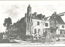
 Eleanor Cross
King Edward I had elaborate stone crosses erected in memory of his wife Eleanor of Castile, marking the twelve overnight resting-places along the route taken in 1290 when her body was transported to London. Only three remain in place today, at Geddington, Hardingstone and Waltham Cross; Charing Cross is a replacement.
Jan Scrine
30 November 2012
Travellers thro Time – a poem Read More »

This is the story of a guide stoop. Errr, wot’s a stoop? Stay with me and you’ll find out!
How did people find the way before there were satnavs, before there were maps or even roads? Yes, they asked other people, who said ‘turn left at the big tree’ or ‘go straight past the tall stone’ – but trees fall over and stones get used for buildings. People easily got lost, especially on the moors of the Pennines.
In the late 1600s, a lady and her two children set out to walk the twenty miles to Sheffield to spend Christmas with her sister. They lost their way and their bodies were not found till the snow melted in Spring; they were huddled together in a hollow. This caused a public outcry and the Government passed a law in 1697, making the local Justices set up markers on tracks across the moors and at places where these tracks met. These way-markers were made of locally-available materials, and in the Pennines that meant stone. The word ‘stoop’ comes from the Norse word for a stone, so guide stoops are guide stones.
Now let’s look at an example…
 The one in the picture is at Farnley Tyas, at the junction of three packhorse tracks, now tarmac’d roads. It is a typical example and is designated Grade ll* listed, by English Heritage, so has been protected by railings.
Let’s take a closer look and see what the lettering says. On this side, it has the names of Jono Hoyle Constable and Thos Bottmly Surveyor, and a date, 1738. At that time, the parishes or townships were responsible for the highways and tracks that passed through; local people had to spend several days each year working on repairing the roadways or else pay money instead. The Constable enforced the law and the Surveyor organised road works – both were unpaid jobs. The stone mason didn’t allow much space for fitting in their names!
Let’s look at the next side. To ‘Hudderffield 3 miels’ No, he hasn’t made a mistake spelling Huddersfield, that was the old way of writing an ‘s’, it looked like an ‘f’ (though not exactly the same, lacking the short cross-piece in the middle). But he has spelled ‘miels’ very quaintly.
Now let’s look at the other sides – Holmfirth 2 miles, Pennyftone 6 miles, with pointing hands. Now that you know about the f for s, you can read Pennystone, or Penistone. But look, ‘miles’ is spelled correctly on both these sides ! Do you think the stone mason had too much ale to drink with his lunch and forgot how to spell? Or did he leave it to his apprentice to finish the carving, maybe?!
This guidestoop has stood guard over this junction for nearly 300 years. At some time, someone fixed a sundial to the top, the marks are still visible.
Because it’s ‘listed’, it can’t be improved or modified without the consent of Kirklees Council’s Planning Department, but the Parish Council had the railings repainted and a stainless steel plaque made, to tell people about the stoop.
How would YOU tell your friends about it? On Facebook? on X? or writing a poem, doing a painting, making a model?
JS / Feb 2013 with minor revisions


The tale of a guide stoop Read More »
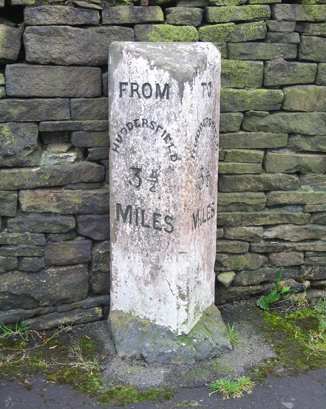
 Apart from Stott Hall Farm, nothing stood in the way of the builders of the M62 trans-Pennine motorway as it made its way over the moors and peat-bogs of Rishworth and Scammonden in 1969 – certainly not the old milestone at Outlane informing drivers (and originally cab-passengers) that they were 3½ miles from Huddersfield.
Ray Wilson, a former Huddersfield Town footballer and a member of England’s World Cup-winning team of 1966, could see it from his father’s funeral parlour which overlooked the construction site. On learning it was about to disappear along with everything else into one of the huge crushing machines on the site, he asked if he could have it, and was told to move it before the machines arrived.
Accordingly, after much strenuous effort (for the stone had as much under-ground as was visible above), it was re-erected in Ray’s garden at Barkisland. It lived there for 32 years.
When Ray left Barkisland in 2006, he and his wife wanted the stone repositioned in Outlane, and finally, in 2012, following the intervention of the Milestone Society, and as part of Kirklees Council’s milestone refurbishment project, it returned home.
Just a few hundred yards from its original site on the westbound sliproad of Junction 23, it can now be found on the original section of New Hey Road, now a cul-de-sac just on the Huddersfield side of the roundabout. Painted white, unlike all the other “to and froms”, but already weathered, it was the furthest from the town centre, and the only 3½ mile stone in existence. They were erected by Huddersfield Corporation in the 1880s or 90s for the purpose of calculating cab fares, which, it is thought, were priced per half-mile.
Source: Milestones & Waymarkers, 2012, vol 5, p 20; Huddersfield Examiner, 29 Nov 2006. RWH / November 2012
The saga of the Huddersfield 3½ mile “to and from” Read More »


In 2006 funding was obtained by Kirklees MBC (covering Huddersfield and district) to restore and conserve the many milestones – there are over 100, not counting an even greater number of boundary stones – in the District.
A number of Brayshaw and Booth stones on the Wakefield to Denby Dale road (A636) were duly refurbished and then all went quiet. Persistent enquiries revealed a catalogue of unfortunate events: those involved had retired, been transferred, or made redundant; the depot had been closed; the foundry in Cheshire where the plates had been sent for refurbishment had gone into liquidation.
A happy ending has, however, finally been achieved, and in 2012 a number of stones have re-appeared. These include stones at Lepton (A642), Grange Moor and Flockton (A637), Holmfirth, and the only 3 1/2 mile Huddersfield “to and from”. (See separate article for the saga of this stone.)
Another development has been a “Diamond Jubilee” refurbishment of a Brayshaw & Booth stone at Mirfield. This has been painted blue, in accordance with the colour stipulated in the original contract in 1893 (see Brayshaw & Booth article), but with gold rather than white lettering. It looks very fetching, but one can understand why the colour was changed to white, as it is far harder to read.
The Milestone Society is grateful to Kirklees for its continuing commitment to this project.
Source: Milestones &Waymarkers, 2012, vol 5, p 48. RWH / November 2012
The Kirklees milestones restoration project Read More »
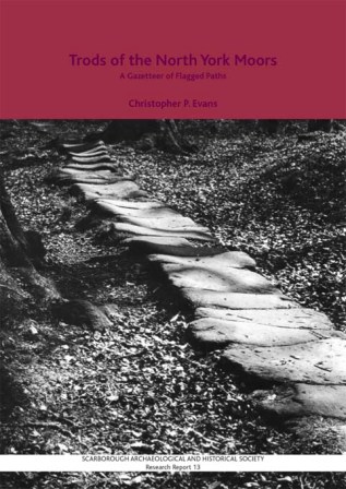
 A trod, according to the OED, is a dialect word for a trodden way, a footpath, path, or way. Brockett’s Glossary of North Country Words in Use of 1825 describes it as a foot path through a field.
The word is still in use, having been revived by Christopher Evans from Scarborough, who has tramped across miles of field and moorland tracing the route of these old ways across the northern parts of the North York Moors.
The essential feature of a trod is the single row of large stone flags, as seen on the cover of Evans’ book (pictured right) in an old photograph by Frank Meadow Sutcliffe, the Whitby photographer (1853-1941). His photographs show a number of trods which have now vanished, and Evans believes that perhaps only 20% of them survive.
Nineteen “long trods” have been identified, some running from the northeast coast southwestwards; some following or crossing dales, such as Eskdale (both the north and south banks) and Glaisdale. Two notable ones are:
* The “George Gap Causeway”: Blakey Ridge through Rosedale and Great Fryup Dale (a very steep descent, and trods can be very treacherous when wet) to Staithes;
* “Quakers’ Causeway”: from White Cross (just east of Commondale) over Commondale Moor to Guisborough; the present name is obviously later than the trod, which may have a monastic origin, leading as it probably does to Guisborough Priory.
But shorter trods are found all over the moors; they lead to individual farms, mills and churches. And locally they converge on market towns (and former market towns such as Egton near Whitby, and Castleton in Danby Parish).
There is no single reason why trods were constructed. They do not tally exclusively with the existence of monastic properties, though many may have such links, and it is probable that monastic labour helped create them – they are even sometimes referred to as Monks’ Trods. Nor do they tally precisely with the locations of mineral workings (alum, iron or coal), or with the locations of crosses and other waymarkers (although some can be found on them, and many continue to be rights of way today).
The key factor in any road’s existence, however, is to connect goods from their place of origin with the people who want them: the trods that lead from the coast provide one obvious example, connecting fish with local markets.
The earliest ones date from mediaeval times, and they were still being constructed in the 18th century: Castleton, for example, did not develop until this later period.
Many trods are vulnerable by running alongside later highways, but the North York Moors National Park Authority is aware of their historical significance, as are some local history groups, and it is hoped that concerted efforts will be made to preserve those that survive.
Source: talk given by Chris Evans to the Milestone Society at Hebden, April 2012.
RWH / April 2012
Trods: flagged paths in north-east Yorkshire Read More »


The Sedbergh Turnpike Trust, based in the far north-west corner of the old West Riding, was unusual in that rather than having a single road going from A to B, it comprised five roads all radiating from Sedbergh.
The Act establishing the Trust was passed in 1761/2, and covered the following roads:
In 1840 the Trust is recorded as having 62 miles of road and seven main gates.
The Sedbergh Trust’s milestones are all to a standard, distinctive pattern: a rectangular base with up to 50 cm of worked stone, plus rougher stone deeper in the ground; above this is a D-shaped column with a slightly domed top. The whole is shaped from a single piece of stone and has a rough unworked back. Destinations are indicated simply by their initial letters – though in Dentdale only the mileage to Sedbergh is shown – and some stones have the township name on the base.
These milestones survive on all the Trust’s roads except the Hawes road (A684), where they were replaced by the new County Council mileposts (West and North Riding). Those on the Dent road were presumably considered too minor for the West Riding County Council to replace them in 1894. Similarly the WRCC did not bother to replace the milestones on the short West Riding stretches of two of the roads which led into Westmorland, to Kendal and Kirkby Lonsdale.
In 1825 the road from Hawes to Kirkby Stephen was turnpiked. The central section of this, from the lonely Moorcock Inn at Garsdale Head to Appersett, was the existing Sedbergh-Askrigg road; from Appersett the turnpike continued to Hawes and Gayle, and from the Moorcock it went down Mallerstang to Kirkby Stephen. Its milestones are similar in design to those of the Sedbergh Trust.
Sources: Geoffrey N Wright: Roads and trackways of the Yorkshire Dales (Moorland Publishing, 1985); Christine Minto: The Sedbergh Turnpike (Milestone Society Newsletter, Jan 2006, no 10, p 17); www.turnpikes.org.uk.
RWH/April 2012
The Sedbergh Turnpike Trust and its milestones Read More »