
The tale of a guide stoop
This is the story of a guide stoop. Errr, wot’s a stoop? Stay with me and you’ll find out!
How did people find the way before there were satnavs, before there were maps or even roads? Yes, they asked other people, who said ‘turn left at the big tree’ or ‘go straight past the tall stone’ – but trees fall over and stones get used for buildings. People easily got lost, especially on the moors of the Pennines.
In the late 1600s, a lady and her two children set out to walk the twenty miles to Sheffield to spend Christmas with her sister. They lost their way and their bodies were not found till the snow melted in Spring; they were huddled together in a hollow. This caused a public outcry and the Government passed a law in 1697, making the local Justices set up markers on tracks across the moors and at places where these tracks met. These way-markers were made of locally-available materials, and in the Pennines that meant stone. The word ‘stoop’ comes from the Norse word for a stone, so guide stoops are guide stones.
Now let’s look at an example…
 The one in the picture is at Farnley Tyas, at the junction of three packhorse tracks, now tarmac’d roads. It is a typical example and is designated Grade ll* listed, by English Heritage, so has been protected by railings.
Let’s take a closer look and see what the lettering says. On this side, it has the names of Jono Hoyle Constable and Thos Bottmly Surveyor, and a date, 1738. At that time, the parishes or townships were responsible for the highways and tracks that passed through; local people had to spend several days each year working on repairing the roadways or else pay money instead. The Constable enforced the law and the Surveyor organised road works – both were unpaid jobs. The stone mason didn’t allow much space for fitting in their names!
Let’s look at the next side. To ‘Hudderffield 3 miels’ No, he hasn’t made a mistake spelling Huddersfield, that was the old way of writing an ‘s’, it looked like an ‘f’ (though not exactly the same, lacking the short cross-piece in the middle). But he has spelled ‘miels’ very quaintly.
Now let’s look at the other sides – Holmfirth 2 miles, Pennyftone 6 miles, with pointing hands. Now that you know about the f for s, you can read Pennystone, or Penistone. But look, ‘miles’ is spelled correctly on both these sides ! Do you think the stone mason had too much ale to drink with his lunch and forgot how to spell? Or did he leave it to his apprentice to finish the carving, maybe?!
This guidestoop has stood guard over this junction for nearly 300 years. At some time, someone fixed a sundial to the top, the marks are still visible.
Because it’s ‘listed’, it can’t be improved or modified without the consent of Kirklees Council’s Planning Department, but the Parish Council had the railings repainted and a stainless steel plaque made, to tell people about the stoop.
How would YOU tell your friends about it? On Facebook? on X? or writing a poem, doing a painting, making a model?
JS / Feb 2013 with minor revisions


The tale of a guide stoop Read More »
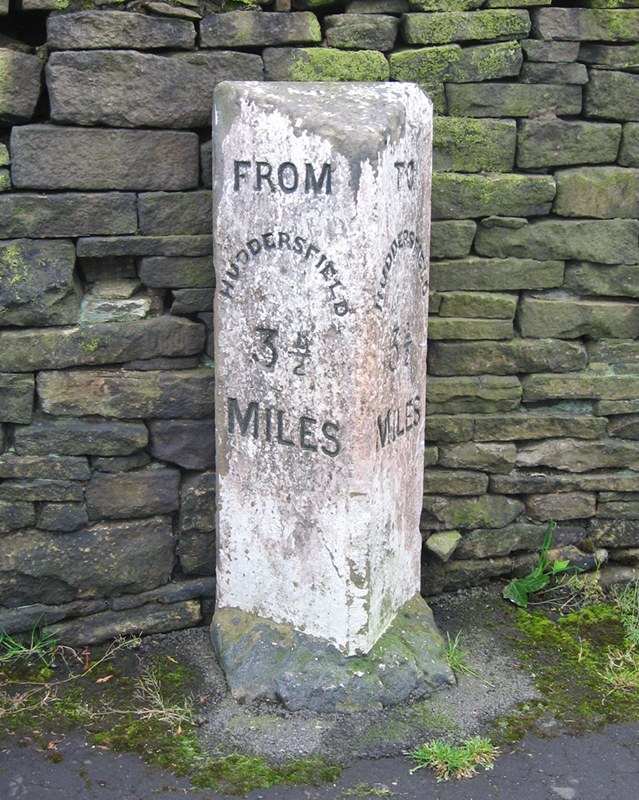
 Apart from Stott Hall Farm, nothing stood in the way of the builders of the M62 trans-Pennine motorway as it made its way over the moors and peat-bogs of Rishworth and Scammonden in 1969 – certainly not the old milestone at Outlane informing drivers (and originally cab-passengers) that they were 3½ miles from Huddersfield.


 A trod, according to the OED, is a dialect word for a trodden way, a footpath, path, or way. Brockett’s Glossary of North Country Words in Use of 1825 describes it as a foot path through a field.


 In the 16th century a stone was found in Booth Bank Clough, between Slaithwaite and Marsden, one of the little streams that drops down into the River Colne. It was set up, in 1587, in the grounds of Slaithwaite Manor House, and became known as the Dial or Dyall Stone. Despite having been taken, for some unknown reason, to the Isle of Man in the 19th century, and later re-sited outside Slaithwaite Town Hall on Lewisham Road, it can still be seen at the Manor House, off Nabbs Lane in the centre of Slaithwaite.
 One of the most unusual guide-stoops in the county can be found just off the A616 Stocksbridge bypass in South Yorkshire: it is, as far as we know, unique in having six sides.
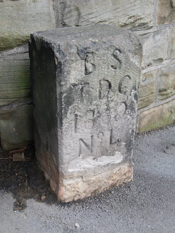
 Up to the 19th century a parish was a parish, for both church and local government purposes. In the north some parishes were very large, covering many separate settlements. (The largest was Rochdale, whose huge area extended even into Yorkshire). For local government purposes these large parishes were divided into townships; Bradford, for example, contained thirteen and Halifax over twenty. Similarly, for ecclesiastical purposes, because the parish church could be so far away, chapelries were created, and chapels of ease were built in outlying districts (eg at Elland, Heptonstall, Ripponden and Sowerby in Halifax parish).