Uncategorised

Thorpe St John Chapelry boundary stones

There are several Thorpes in Yorkshire, but this is about one on the road between Triangle and Ripponden near Halifax.  It’s not really a place, more just a house (now a bed & breakfast) and a mill (now apartments) – and, for less than a century, a church.  Thorpe House was lived in by Frederick Rawson, a woollen manufacturer who owned the mill next-door and had the church built.

There were already old-established churches in Ripponden and Sowerby, both just over a mile away, and in 1848 a church, St Mary’s, was opened at nearby Cottonstones to serve the population of Mill Bank.  This had been built with money left in the will of Ellen Hadwen, who died in 1842.  She was a member of a family of cotton-spinners who owned various mills (not all surviving) at Kebroyd, just along the road from the Rawsons of Thorpe.

Despite all these, and perhaps out of local rivalry, Rawson decided to finance and build his own church, dedicated to St John the Divine, on land slightly nearer Triangle.  He died in 1879 with the church not quite finished, but the work was continued by his widow Harriet and the church was consecrated the following year.  It seated 300 people, and a Sunday School was built alongside for 200 children. 

This being the Church of England all new church-building had to be authorised by the monarch, and announced in the London Gazette, the official record.  The Thorpe St John Consolidated Chapelry (so-called because it was created out of more than one existing parish) was listed, with a detailed schedule of its boundaries, in the issue of 6th September 1881 – this despite being already built and functioning.

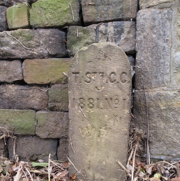
The boundaries of the Thorpe chapelry refer to two boundary stones, both of which still stand.  From Kebroyd the boundary reaches “the eastern boundary of the buildings and premises called or known as Dean House and extending thence northward to and along the said wall or fence for a distance of eleven chains or thereabouts to a boundary-stone inscribed ‘T. St. J. C. C. 1881. No. 1’ and placed at the northern end of the same wall or fence on the southern side of Dean-lane”.

Skirting Mill Bank it then reaches a point “at or near to the junction of Birks-lane, Helm-lane, and Bowood-lane and extending thence north-eastward along the middle of the last-named lane for a distance of fifteen chains or thereabouts to a point opposite to a boundary-stone inscribed ‘T. St. J. C. C. 1881. No. 2,’ and placed on the south-eastern side of the said last-named lane at a distance of exactly four chains to the north of the junction of the same lane with Green-lane”.

The first stone, on Dean Lane, is just outside no 7, Saw Hill, and has recently (Autumn 2020) been cleared of the ivy which had hidden and presumably protected it.  It is in very good condition.  The second, on Bowood Lane, is about ½ mile north of Mill Bank, on the right-hand side of the road, built into a wall and now somewhat eroded.

The population of the area covered by the new church was not large, and it must have always struggled to have a viable congregation.  In 1917 it suffered a disastrous fire and was rebuilt.  In 1941 it became part of an amalgamated parish with the Cottonstones church, but was finally closed in 1968 and demolished in 1973.

Sources: Albert Senior: St John the Divine, Thorpe: souvenir of the Jubilee, Sept 20th 1930 (published 1930); London Gazette, 6 September 1881 (available online); Malcolm Bull’s Calderdale Companion (website)

RWH / April 2021

No 1
No 2

Thorpe St John Chapelry boundary stones Read More »

Spur-stones: nothing to do with milestones

Spur-stones have nothing to do with milestones or the Milestone Society, but they can cause confusion.  So I thought it useful to mention them here. In some areas they are also known as jostle-stones.

A spur-stone, according to the Oxford Dictionary, is a stone fixed in the ground to support a post or to keep vehicles away from the footway, etc.  More specifically, James Stevens Curl in A Dictionary of Architecture and Landscape Architecture (2 ed; OUP, 2006) defines it as an upright stone, often circular on plan, like a bollard, fixed in the road at an angle of a building or on each side of a vehicle-entrance to protect the corners.

The OED’s first traced use of the word is in the Gentleman’s Magazine of March 1848.  In this a letter from a correspondent, B P of Maidstone, describes a mediaeval pillar or obelisk unearthed in Northampton in 1823, “part of it before having been above ground as a spur-stone.  …  The stone, when adopted for a spur-stone, seems to have been chiselled and trimmed at the top”.  The use of the word here implies that it was well-known (at least among gentlemen), needing no further explanation.

In 1882 Richard Jefferies in Bevis: the story of a boy writes:

Bevis battered his flints till he was tired; then he took up the last and hurled it away in a rage with all his might. The flint whirled over and over and hummed along the ground till it struck a small sarsen or boulder by the wood-pile, put there as a spur-stone to force the careless carters to drive straight.

Jefferies came from Wiltshire, and Joseph Wright’s six-volume English Dialect Dictionary of 1898 describes it as a Wiltshire term, but this is presumably based on the Bevis quotation.  He defines it as “a projecting stone … to keep the traffic from coming too close”.

The term “bollard” is used in a definition above, and this word can also be synonymous with spur-stone.  Originally, in the 19th century, this was a nautical term to describe a “post on a ship or a quay for securing ropes to” (OED), possibly derived from “bole” – the stem or trunk of a tree, and by transference anything of a similar cylindrical shape.  Its present use for an item found on pavements, traffic islands, etc, dates only from 1948.

So why is all this relevant to milestones?  Because sometimes they can be confused with each other when located close together, when place-names have been erased, or when a milestone or similar waymarker is lost.

Two such stones are illustrated here.  One, enjoining passers-by to stick no bills, is on Leeds Road in Huddersfield, not far from where a half-mile stone would have been – had there been one, which there wasn’t.  The other, plain, is by a driveway in Wilshaw, Meltham.  It stands almost exactly on the one-time boundary between Meltham and Netherthong.

As for jostle-stones the derivation of these is uncertain. Wright’s English Dialect Dictionary of 1902 has the term jostling-stone, but defined rather as “a block or stone on which a boy is bumped when the bounds of the parish are beaten”.  He also has jostling-block: a block or stone used in mounting a horse.  Both uses are from East Anglia.

Another term found is guard-stone. The OED defines these as “One of a row of stones placed to keep vehicles off the sidewalk”, which is a subtly different concept.

Sources: as quoted; see also http://blog.waterfordmuseum.ie/2020/11/our-heritage-in-stone-spur-stones-stone.html for two Irish stones, and https://www.dreamstime.com/spur-stone-building-made-old-cannon-cayenne-capital-french-guian-spur-stone-building-made-old-cannon-image131721380.  This pictures a re-used bit of a cannon in Cayenne, French Guiana – a similar practice to the re-used mediaeval pillar in Northampton.

RWH / April 2021, updated March 2025

Spur-stones: nothing to do with milestones Read More »

Village signs

Village signs come in all shapes and sizes.  There are the ubiquitous simple road-side notices telling you the name of the community you are entering (not to be confused with boundary stones, being rarely on the actual boundary).  And then there are the big round yellow signs put up by motoring organisations (mainly the AA) in village centres a century or so ago, many of which survive.

There is, however, a growing trend for local communities to show off their village with large attractive signs, illustrative of interesting or historical features of the place.  “Village signs” is sometimes hardly an adequate term for what are often little works of art. 

To promote and record these the Village Sign Society (www.villagesignsociety.org.uk) was founded in 1999.  Perhaps originally an East Anglian phenomenon (Norfolk has the most), they have recorded over 5,000 across the country, and over 200 in Yorkshire.

The sign pictured here, at Millhouse Green, on the Barnsley-Manchester road near Penistone, is typical of recent, more elaborate signs.  It was designed and made by local businessman Nigel Tyas and sculptor Jim Milner (www.jimmilnersculpture.co.uk), and unveiled at the village’s Jubilee Fete in 2012.  Featuring a typical local scene it also has the logo of the village community association, designed by pupils of the village school.

RWH / Nov 2020

Village signs Read More »

IWB: 19th century engineer and graffitist

Isaac Watt Boulton was born in 1823 in Stockport, and allegedly related to the more famous Boulton family, Matthew (1728-1809) having manufactured steam engines in partnership with James Watt.  Living in Ashton, Isaac built and repaired steam engines of various kinds, and was the inventor of patent block wheels for traction engines and a pioneer of narrow-gauge railways.  He started to hire out railway locomotives, constructing in 1864 Boulton’s Siding, alongside the Oldham branch of the Manchester, Sheffield and Lincolnshire Railway.  This lasted until 1898, the year before he died, a lauded local worthy, a JP and an alderman.

What, you may ask, has this to do with milestones and waymarkers?  Well, Isaac was a passionate believer in fresh air and free access to the countryside.  He was a keen rambler, an authority on the Peak District, and campaigner for public access to ancient paths over Kinder Scout – half a century before the famous “mass trespass”.  Rambling was his great recreation, and there were few things that pleased him better than the suggestion of a good walk over the moors.  He also operated the first pleasure-boat on Hollingworth Lake, which he was convinced could be made into a pleasure resort.

In May 1893 the Ashton-under-Lyne Herald published an article from IWB describing a walk done the previous weekend “that may help some of your younger readers who believe in walking as a healthy exercise and are anxiously looking forward to the Whitsuntide weekend for the purpose of going on a long tramp over mountains and moorland.”  He travelled by train to Woodhead, arriving at 8 am, and breakfasted on “oatcakes off the flake, fresh butter and a glass of beer” whilst chatting with “the genial landlady” of the Millers Arms at Saltersbrook – now long gone. 

He left his mark on the district in ways we would not approve of now, and the initials IWB can be found carved (sometimes quite crudely) in several places in the district.  Opposite the ruins of the Millers Arms against the wall can be seen a milestone inscribed IWB.  On the old saltway, this milestone, the last in Yorkshire (or the first if coming from Cheshire), marks the halfway point between Rotherham and Manchester – 21 miles each way.  The stone is very eroded, but the original inscription was to “Wortley XII Miles Rotherham XXI Miles”. The initials IWB can just be made out at the bottom of the photograph (above right).

Two miles west of this, on the same old saltway, north of the present A628, the 19 miles to Manchester stone has been incorporated into a wall; it also bears the initials IWB – pictured left.  Originally in Cheshire, this is now Derbyshire.

The Lady Cross

Nearer Rotherham on the same track, now south of the A628, is the Lady Cross.  Its exact date is uncertain, but it is referred to in documents from the early part of the 16th Century.  It stands on the eastern edge of the manorial lands of Glossop, and will also have acted as a marker to indicate the direction of the track over what was a featureless landscape.  The initials IWB are clearly visible on the base.  Nearly a mile further south, near Dean Head Stones, just over the county boundary, a tapered stone also bears his initials.

Sources: Stocksbridge & District History Society; Grace’s Guide to British Industrial History; obituary of Boulton from an un-named and undated newspaper cutting made available by the New Mills History Society at www.newmillshistory.org.uk/sbook/sbook1_001.pdf

RWH / October 2020

IWB: 19th century engineer and graffitist Read More »

Some Yorkshire bridges

Wakefield’s mediaeval bridge and chantry chapel. The nine-arched bridge, over the River Calder, was built between 1342 and 1356, when the chapel was also consecrated. The new bridge was built alongside in 1929-30.
Marsden’s Eastergate packhorse bridge, on an old route to Rochdale. The original bridge would not have had walls, or the horses’ packs would not have got through.
Aldwark toll-bridge: one of a small number of old toll-bridges surviving in the UK. It is the only crossing of the River Ure between York and Boroughbridge, connecting the villages of Aldwark (in the old North Riding) and Great and Little Ouseburn (in the old West Riding). It was built in 1772 by John Thomson, who had formerly ferried people across in a rowing-boat: he obtained a private Act of Parliament to build the bridge. It’s quite scary crossing it, but well worth the 40p it now costs – though the toll-collector is said to go home at 7.30 pm.
North Bridge, Halifax: a magnificent cast-iron Victorian gothic structure built in 1869 over the rather insubstantial Hebble Brook (and the railway).
Middlesbrough’s Transporter Bridge, completed in 1911.
Scammonden Bridge: photo taken in 1970, when the M62 in a huge cutting below was still under construction.
The Humber Bridge, from the Barton-on-Humber side; opened in 1981. Photograph on Geograph: cc-by-sa/2.0 – © David Wright  https://www.geograph.org.uk/browser/#!/q=humber+bridge/image=263502

Some Yorkshire bridges Read More »

A milestone on an East Riding war memorial

In Sledmere in the East Riding there are two war memorials, near the church and Sledmere House, home of the Sykes family from the mid-18th century when it was built, replacing an earlier manor house. 

The Wagoners Memorial

One is a copy of an Eleanor Cross, erected at the end of the 19th century as a village cross and converted into a war memorial in 1919 for the men of the estate. 

The other is known as the Wagoners’ Memorial.  It celebrates the Wagoners Special Reserve, a unit set up by Sir Mark Sykes, the 6th Baronet.  He enrolled farm labourers and tenant farmers on the Wolds to serve as drivers of horse-drawn wagons; they had a vital role moving essential equipment during the war.

This memorial, designed by Sykes and constructed by Mr Barr the estate mason, has a sculptured frieze curving round a central column.  This was done by Carlo Magnoni, an Italian artist living in London.  It shows scenes from the wagoners’ history: from enlistment through tearful farewells to active service against a caricatured enemy.  The milestone appears as they leave for France: it marks (correctly for Sledmere) 8 miles from Driffield and 24 miles from York.

“Farewell, old friend”

The milestone does not resemble those on the western section of the main Driffield-York road (the A166), which runs about four miles south of Sledmere: these are of the mounting-block style.  It is, however, the same shape as the three surviving stones on the B1251 section of the road between Sledmere and York – that is, through Fimber as far as Fridaythorpe – and two on the A166 outside Driffield.  But we cannot be certain what these originally said on them.

Source: Ian Sumner: The Wolds Wagoners: The story of the Wagoners’ Special Reserve (Sledmere Estate, 2000)

RWH / September 2020

A milestone on an East Riding war memorial Read More »

Boundary stones around Clapham

In the north-west of the old West Riding over a dozen stylistically identical boundary stones can be found, all in an area between Giggleswick and Ingleton.  They are made from a single slab of Helwith Bridge blue slate, from a local quarry – Helwith Bridge, over the Ribble is about four miles north of Settle. 

They have a triangular top and a v-shaped groove down the centre, with the parish or township names attractively carved on each side.  Historic England, who have listed many of them, describe them as early 19th century, but they may be later as they do not appear on Ordnance Survey maps until the 1890s.

Nearly all the surviving ones are in Clapham parish, which comprised the townships of Clapham, Austwick and Lawkland, and the hamlet of Newby.  Others can be found on the borders of half-a-dozen nearby townships, including Ingleton/Horton, Horton/Stainforth, Stainforth/Arncliffe, Stainforth/Giggleswick and Langcliffe/Settle.

The one illustrated here, marking the boundary between Austwick and Lawkland townships, is near a bend on the A65 (Milestone Soc ID YW_AUSLAW01pb; grid ref SD 7793 6745).  There are three more on this boundary, including one on the lane leading into Lawkland.  This is no longer the parish boundary, however, it having been moved to run along the main road, probably in the 1930s.

A similar stone can be found on a minor road between Ingleton and High Bentham.  Made of the same material, it differs in that the I and the B are in larger capitals while in all the others all the letters are the same size.  The top is level rather than triangular, but this may not always have been the case.  This stone is illustrated on the front of Angus Winchester’s Discovering parish boundaries (Shire Publications, 1990).

Clapham township extended over five miles south of the village onto the moors, to an area called Clapham Common.  Austwick does the same to the east, and they share a long straight featureless  boundary.  (A detached portion of Lawkland between them to the north was transferred to Austwick in 1884).  Near a place known as Dovenanter is a much earlier boundary stone: a square block with A for Austwick on one side and C for Clapham on the other.  Winchester’s book pictures this standing up, but Humphrey Bolton’s 2018 photograph on Geograph shows it has fallen over – see www.geograph.org.uk/photo/5871545.  [Unless, of course, there’s more than one].

Who had the slate stones made and put up is not known.  While most of them are in the parish of Clapham, it was the townships rather than the parish who would have had the responsibility for marking their boundaries.  Similarly, while turnpike trusts might have erected boundary stones, most of these are not on the turnpikes.

One possibility, therefore is that a newly-formed district Highway Board erected them in the later 19th century.  They took over responsibility for all roads, including turnpikes, and this could explain their uniqueness to this area.  I have not, however, traced any reference to a Highway District covering this district (eg for Ewecross, the wapentake which included Clapham parish).

Another possibility is that they might be related to tithe maps.  These were produced in the 1840s, following the Tithe Commutation Act of 1836.  Tithes were a local tax on agricultural produce, and the Act allowed tithes to the church, which had traditionally been paid in goods (eg crops or animals), to be paid in cash.  Large-scale maps were produced for most townships, showing every building and feature, natural and man-made, and land usage.  [Tithes were not abolished until 1936].

A tithe map for Clapham-cum-Newby township was produced by John Watson (Junior) of Kendal in 1847.  It shows “manorial boundary, buildings (named), vicarage, school, boat house, old mill, gardens, sundial, grotto, boundary stones, field gates, sheepfolds, pinfold, parkland, plantations, quarry (sand), pot hole, named hills, hill-drawing (slopes, knoll), woods, waterbodies, wells, springs, bridges, railway with station, footpath and/or bridleway. Turnpike roads distinguished; toll bar” at a scale of 1 inch to 3 chains.  The same surveyor produced a tithe map for the combined townships of Austwick and Lawkland, also in 1847.  Further research is needed here.

Another possibility is that they are somehow related to enclosures.  Similar maps were produced, often by the same surveyors, at around the same time, eg for Clapham in 1849.  This was surveyed by John Greenwood of Gisburn, who had assisted in the production of the tithe map for Giggleswick in 1841-43.

None of these possibilities, however, explain why the boundary stones can be found in unrelated townships.  So maybe a final possibility is that they began life in one township and others decided to copy them – or the quarry owners did an effective marketing exercise.

Please let us know if you have any further information on these attractive stones.

RWH / Sept 2020   

Boundary stones around Clapham Read More »

Handstones: guide-stoops on the North York Moors

The ruling about the need for guide-stones in moorland areas was acted on by the North Riding County Justices in 1711 (eleven years after the West Riding).  They ordered that guideposts should be erected throughout the county; they were to be hewn from huge pieces of stone and set up in locations where roads, trackways and  footpaths, used by the numerous packhorse trains (as well as solitary travellers even more likely to get lost on a bad day) crossed.

We call them guide-stoops but locally they are referred to as handstones.  They were relatively plain four-sided upright stone slabs, with the names of villages roughly inscribed on the four faces.  And hands: very crudely chiselled but very distinctive.  The stone-masons, probably illiterate, often had difficulty with the letters and their spacing.

They can be found on Blakey Ridge (north of Hutton-le-Hole), Urra Moor (very worn), Ingleby Moor (with the date 1757) and elsewhere.

Here is a selection.

Sources: Historic England website; anonymous article on ‘North York Moors: guide posts or stoops – known locally as handstones’ (no further details).

RWH / September 2020

The north-facing side of the Blakey Ridge stone. Guisbrough is roughly 15 miles north of the stone, so presumably the hand pointing up in the air means “It’s behind you”. .
The west-facing side of the Blakey Ridge stone. This points down what is now a mere track to Lowna and on via Gillamoor to Kirkbymoorside.
The east-facing side of the Blakey Ridge stone points south down the road to Hutton-le-Hole, about 2 miles away – whence Pickering or Malton can be reached. The stone (Milestone Soc ID YN_XSE6992) is at SE 6936 9255.
The stone on Ingleby Moor in the north-east of the district on a very old track between Ingleby Greenhow and Kirkbymoorside. Milestone Soc ID: YN_XNZ6004. Grid ref: NZ 6040 0422
On the road between Commondale and Kildale, just outside the former. Three hands point to Whitby, Stokesley and Jisber (Guisborough). Milestone Soc ID: YN_XNZ6510. Grid ref NZ 655 105.
A very weathered handstone on Urra Moor. Milestone Soc ID: YN_XNZ5901a. Grid ref: NZ 5943 0150.

Handstones: guide-stoops on the North York Moors Read More »

Some Yorkshire toll-houses

On the A669 at Greenfield
At a private bridge at Copley, Halifax
Stump Cross, Halifax: junction of A6036 and A58
At Scarcroft on the Leeds to Wetherby road, A58
On Rowley Lane, Lepton, once part of the Wakefield Austerlands Turnpike
On the county boundary at Sharneyford, A681 between Todmorden and Bacup
Replica table of tolls on the A616 at Brockholes, New Mill District Roads
In Sussex (sorry!): original toll-keeper’s cottage at the Weald and Dowland Open Air Museum

Some Yorkshire toll-houses Read More »

Towler milestones in the West Riding

While the plates for most of milestones erected for the West Riding County Council in the 1890s were cast at Brayshaw & Booth’s foundry in Liversedge, a small number were made at William Towler’s Globe Foundry in Leeds.  We have no evidence regarding why he was involved, but possibly he was brought in later in the project to ensure it was completed in time.

Towler’s plates can be found on at least four roads in the north of the county: the A629/A65 Keighley to Kendal Road (at Farnhill, south of Skipton, Long Preston and Thornton-in-Lonsdale); the A683 Sedbergh to Kirkby Stephen Road, at Cautley (illustrated); and the A684 Sedbergh to Hawes road.  They are also on the B6255 Lancaster to Richmond Road (on the section through Ingleton as far as the old county boundary). Curiously this bit of road is not listed on the original contract for the milestones, so perhaps it was part of a second as yet untraced scheme. From the style it is probable that the other stones on these roads were also Towler’s: the name is not always discernable, but they are slightly different from the Brayshaw & Booths.

Spot the difference

The original foundry was in existence in the early 19th century.  The 1847 OS map shows a foundry off Water Lane on Globe Road in Holbeck, and Towler is first mentioned in Kelly’s West Riding Directory of 1881, where Dyson & Towler are listed as ironfounders on Globe Road.   The firm also had a warehouse or showroom on Assembly St in the centre of Leeds.  This building was originally the east side of the White Cloth Hall, opened in 1777, with assembly rooms on the top floor for the well-to-do in Georgian Leeds.  It has been much altered and the other three sides demolished since, but it survives, is now listed, and is called Waterloo House.

The warehouse advertised chimney pieces, tiles, ovens, ranges, set-pots, mangers, stoves and all kinds of fire-places according to a photograph of around 1900-1910.  [A set-pot is  a stone boiler or ‘copper’, with a fire-grate under, for the purpose of boiling and ‘stewing’ dirty linen, according to Robinson’s Dialect of Leeds and neighbourhood].  They also produced coal-chute covers and grates for drains, which can still be found in the district.  And, of course, milestones.

The company flourished for another half-century, but finally closed down in 1959.

Sources: various items turned up by search engines under ‘towler globe foundry leeds’; the photograph at the top, from the four miles to Sedbergh stone at Garsdale on the A684, is taken from a Milestone Society journal; illustration and listed building detail of Towler’s warehouse at http://www.leodis.net/display.aspx?resourceIdentifier=2003103_38804263&DISPLAY=FULL and https://historicengland.org.uk/listing/the-list/list-entry/1375290

RWH / rev July 2025

Towler milestones in the West Riding Read More »