
Guide-stones around Skipton: the ‘Craven stoops’
Around the Skipton area are over 20 small triangular stones, mostly painted white with black lettering, most with a pyramidal top, and found mostly at minor road junctions. Village names, sometimes with arrows or crude hands painted on them, direct the traveller along the lanes.
They can be found throughout the Craven District – in Bolton Abbey, Coniston Cold, Cracoe, Draughton, Eshton, Gargrave, Linton, Stirton-with-Thorlby, Thorpe and Threshfield.
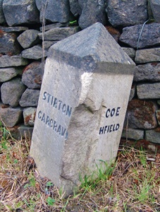
A typical example, YN_XXSGCT, illustrated here, is on the B6265, about a mile north of the Skipton northern by-pass. It is at the junction of Bog Lane (an indication, perhaps, of its formerly uninviting condition) with the B6265, just before the oddly-named None-Go-Bye Farm. The narrow Bog Lane leads directly to Stirton, and thence to Gargrave – as indicated on the left-hand side of the stone. The right-hand side shows directions to Cracoe and Threshfield (though these destinations are incomplete, perhaps following an altercation with a road vehicle).
There is, however, no indication that the main road leads back to Skipton, suggesting that whoever erected it assumes this is the direction you have come from – though if this was the case and you really wanted to go to Stirton or Gargrave you wouldn’t have come this way.
The stones are stylistically quite different from those erected in response to the demands of the County Justices at the turn of the 18th century: those were aimed at travellers on featureless moorlands. And since there are so many of them in a very similar style they are unlikely to be the work of different parishes.
They were in fact erected in the second half of the 19th century: this stone (like many of the others) appears on the 1896 Ordnance Survey map, but not on the 1853 edition. And they were put up by the East Staincliffe Highway District (ESHD). This was one of many Highway Districts created in the 1860s, taking over the functions of parishes (who thus gave up their highways responsibilities) and, later, the failing Turnpike Trusts. They were abolished following the creation of Rural District Councils in 1894. The East Staincliffe Highway District, named from the ancient wapentake of the same name, also erected a number of boundary stones in the area; these are marked E S H D.
RWH / Feb 2019
Guide-stones around Skipton: the ‘Craven stoops’ Read More »