2013

The Knaresborough Forest boundary stones

The “Forest of Knaresborough” was an ancient area to the west of the present town, first mentioned in 1167, though possibly established even before the Norman Conquest, as a royal hunting-ground. It was not a forest in the modern sense of the word, ie a continuous stretch of woodland, but much more open land. It covered a huge area, around 40 square miles, containing 24 townships between the Rivers Nidd and Wharfe, extending almost as far as Pateley Bridge and Appletreewick.

Stone no 11 at Lippersley Pike

There were attempts to enclose the forest in the 16th and 17th centuries, which all failed due to local opposition. Because of the large number of illegal (though generally small) encroachments that were being made, an investigation was ordered in 1766, resulting in a Commission being set up the following year. This reported that a good deal of the Forest common was “capable of cultivation and improvement”, and the Enclosure Act followed in 1770.
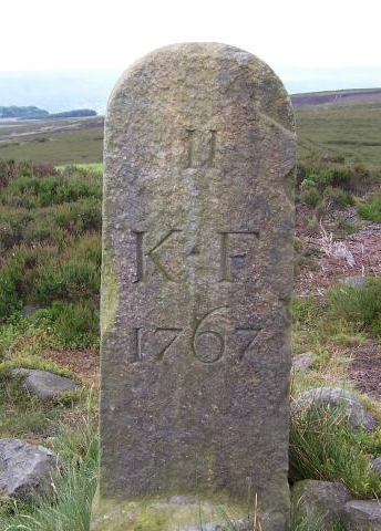
The first task of the Commission, however, had been to establish the forest boundaries. Accordingly a perambulation was announced, starting at Ribston (on the Nidd, three miles south-east of Knaresborough) on September 3rd 1767, with the assistance of local people. The boundary was then marked by a series of round-topped stones carved with a number, the letters K-F, and the date (normally 1767).
There were 49 stones, of which around 30 survive, not all in their original position. The route of the boundary is described in Christopher Butterfield’s booklet (details below), which has photographs of all the surviving stones .

Another more detailed book is by Mike Brough: History and hikes of the ancient royal hunting forest of Knaresborough – in the steps of the 1767 perambulation.  Self-published by the author in 2013, second-hand copies are often available on various websites.

The Commissioners started at the junction of the Nidd and the Crimple (or Crimple Beck), just below Ribston. The boundary follows the Crimple, which flows south of Harrogate, as far as Pannal, where stone no 1 is found, and continues in a clockwise direction to no 49, near the Nidd between Killinghall and Ripley. This is presumed to be the last in the series, as the boundary follows the river back to where the Commissioners started.
Nos 8, 9 and 10 have different dates (1823 and 1825); these are in the parish of Great Timble, and are presumed to be the result of a boundary dispute which took a long time to resolve. Another dispute is possibly responsible for the absence of stones nos 19 to 25 in the lead-mining area around Stump Cross.
Two surviving stones do not conform to the usual pattern (it has been suggested that one stone-mason was responsible for all the stones). These are no 12, at Gawk Hall, on the moors north of Ilkley where four parishes meet, and no 18, at Lord’s Seat, two miles east of Appletreewick. For these the legend has been carved on a large existing natural boulder or outcrop of rock, in situ.

Sources: Christopher Butterfield, comp. and Cyril Mason: The boundary stones of Knaresborough Forest (published by the authors, 6 Ashville Close, Harrogate, HG2 9LZ, 2009); Harrogate WEA Local History Group, ed Bernard Jennings: A history of Harrogate and Knaresborough (Huddersfield: Advertiser Press, 1970); Olwen Middleton: Knaresborough Forest boundaries (Milestone Society Yorkshire News, 2013, no 13, pp 3-5).  Photo by Joe Regan on geolocation.ws.

RWH/June 2013

The Knaresborough Forest boundary stones Read More »

Packhorse train

The Jagger’s Refrain

A packhorse driver sings his disdain for the efforts of the Turnpike Trust to make him pay the toll!

Packhorse train

Play the song below or click here to download it

The Jagger’s Refrain – you can find the words here:

From Halifax to Oldham I tread the old trackways,
I lead my train o’er Cop Hill
and down the cobbled lanes
Past Tyas’ Slawit Manor
and on to Marsden town,
Past stocks and church and hostleries,
my bell horse in the van

The packmen of the Pennines, we bring you pretty things
As well as salt and corn and coal to warm you till the spring.

From Marsden we climb up Pule Hill,
the ways are rough and steep;
The panniers catch on the rocks,
the cloughs are dark and deep.
There’s no way for the wagons or
coaches through these hills,
No way to bring machinery
to set up carding mills –

The packmen of the Pennines, we bring you pretty things
As well as salt and corn and coal to warm you till the spring.

And cross Close Moss to Uppermill
we trek through rain and snow.
The biting wind cuts through my cloak,
my feet freeze with the blow.
But now the highway’s laid below
by Knaresborough’s Blind Jack
He’s crossed the mires with cunning guile
by bundling whin and brack.

The packmen of the Pennines, we bring you pretty things
As well as salt and corn and coal to warm you till the spring.

Jack’s roads are fine, his roads are wide
and coaches will sustain,
But not for me the turnpike road,
for a jagger with his train.
The toll-board at the bar-house
spells it out loud and clear,
It’s thruppence for each pony!
We think it very dear.

The packmen of the Pennines, we bring you pretty things
As well as salt and corn and coal to warm you till the spring.

I cannot spare a florin
That’s all I make each day,
And for the ease of coachmen
I’m not inclined to pay.
They’re welcome to collect their tolls
And though they find it galling,
We’ll keep our old ways cross the hills-
You’ll hear our bells come calling:

The packmen of the Pennines, we bring you pretty things
As well as salt and corn and coal to warm you till the spring.

The Jagger’s Refrain Read More »

1st Holmfirth Cubs

The 1st Holmfirth Cubs went milestoning for their Local Knowledge Badge. Have a look at some pictures of their work by clicking the Read More Link.

Click on any picture to start a slide show.

{gallery}1st_Holmfirth_Cubs{/gallery}

1st Holmfirth Cubs Read More »

Walk of Life Box

Walk of Life –

Walk of Life Box


Begin your walk at the hospital car park. Follow the yellow brick road of childhood to the kissing gate of hormonal teenagers, then fork left and take the gentle incline through Twenty Something Lane.

Around 3 years down you’ll see a stile on the right. (Sometimes the hedgerow is a little overgrown here but there’s another stile a little further down for those enjoying the wild flowers on the lane.)

Once over the stile you’re into the Pasture of the Big Wide World. Stop and soak up the view here as there’s a lot to take in. There is a clear track through the grass but mind the odd thistle and mud patch along the way. Once over the second stile take the bench and think hard before moving on.

You have 2 options here, you can take the 30 year scenic coastal route past wild orchids and rare birds or you can take the more treacherous 20 year route through the Forest of Capitalist Doom. Either way, each passes the Boulder of Middle Age but there’s a steep ascent through the woodland and you’ll need suitable attire here to fend off the pesky nettles!

Each route is clearly signposted and leads to the Waterfall of Retirement. Here you can picnic, paddle in the river and reflect on life’s journey. The hospital car park is off to your left – a few short years away.

Walk of Life Map

Emma Melling, July 2012

Walk of Life – Read More »

Beyond Graffiti – Waymarking thro Time

This is an initiative being launched in Kirklees to introduce younger people to the fascinating heritage of waymarking, in a fun way, through stone-carving workshops, poetry writing, painting, modelling, video making, blogging… and to demonstrate the relevance of that knowledge and those skills today.

STOP PRESS !!  October 2013 – We’ve been awarded funding by the Heritage Lottery Fund as well as the Getty Foundation and individual donors – you can see more information about the programme on our project website, Beyond-Graffiti  www.beyond-graffiti.co.uk  You can also ‘like’ our facebook page, Beyond-Graffiti, which has lots of photo albums, and you can follow us on twitter, @storiesinstone.

A hundred young people in Kirklees participated in the five-sessions programme which ran until November 2014. We also held art and craft exhibitions at Oakwell Hall and The Packhorse Gallery in Huddersfield throughout July 2014, themed Milestones and Waymarking. You can find out all about our project and share in the fun on www.Beyond-Graffiti.co.uk 

Beyond Graffiti – Waymarking thro Time Read More »

alt

Travellers thro Time – a poem

Travellers through Time – 30th November 2012


Milestones are literal as well as metaphorical


I sat on the TransPennine train leaving Leeds –
Passing boarded-up houses, smart empty apartments,
Old mills sprouting shrubs from the tops of their chimneys –
Speeding to York cross agrarian landscapes;
The Wharfe bursting free from her corsetting banks,
Turning flat fields to silver in the bright winter sun.

Flashing through Linton, my thoughts collocating
Recalled other travellers from far distant days
Riders who travelled on foot or by horseback,
Footprints on muddy tracks, marking the ways

The first King Edward setting out sorrowfully
From Lincoln to London, following the coffin
Of Eleanor of Castile, his much beloved Queen,
Taking the long route around through Northampton –
The Great northwards Road, the King’s very own Highway
Full flooded to quagmire from the spill of the Nene.

The farm-labourers and servants, tramping the turnpikes
To Michaelmas hiring fairs, holding mattock or mop,
To be sealed for a shilling, for another year’s labour,
Their lives zig-zagging from homestead to homestead,
Passing by milestones as they moved on again –
Events marked by milestones on footpaths through time.

I thought about students whose own lives will zigzag,
Through waysides untrodden in their ancestors’ time,
And events and turning points, their own personal milestones
Will be recklessly tagged on facebook’s timeline.

 altEleanor Cross

 King Edward I had elaborate stone crosses erected in memory of his wife Eleanor of Castile, marking the twelve overnight   resting-places along the route taken in 1290 when her body was transported to London. Only three remain in place today, at Geddington, Hardingstone and Waltham Cross; Charing Cross is a replacement.

Jan Scrine
30 November 2012

Travellers thro Time – a poem Read More »

IMGP1257

The tale of a guide stoop

This is the story of a guide stoop. Errr, wot’s a stoop? Stay with me and you’ll find out!

How did people find the way before there were satnavs, before there were maps or even roads? Yes, they asked other people, who said ‘turn left at the big tree’ or ‘go straight past the tall stone’ – but trees fall over and stones get used for buildings. People easily got lost, especially on the moors of the Pennines.

In the late 1600s, a lady and her two children set out to walk the twenty miles to Sheffield to spend Christmas with her sister. They lost their way and their bodies were not found till the snow melted in Spring; they were huddled together in a hollow. This caused a public outcry and the Government passed a law in 1697, making the local Justices set up markers on tracks across the moors and at places where these tracks met. These way-markers were made of locally-available materials, and in the Pennines that meant stone. The word ‘stoop’ comes from the Norse word for a stone, so guide stoops are guide stones.

Now let’s look at an example…

IMGP1257The one in the picture is at Farnley Tyas, at the junction of three packhorse tracks, now tarmac’d roads. It is a typical example and is designated Grade ll* listed, by English Heritage, so has been protected by railings.

Let’s take a closer look and see what the lettering says. On this side, it has the names of Jono Hoyle Constable and Thos Bottmly Surveyor, and a date, 1738. At that time, the parishes or townships were responsible for the highways and tracks that passed through; local people had to spend several days each year working on repairing the roadways or else pay money instead. The Constable enforced the law and the Surveyor organised road works – both were unpaid  jobs. The stone mason didn’t allow much space for fitting in their names!

Let’s look at the next side. To ‘Hudderffield 3 miels’ No, he hasn’t made a mistake spelling Huddersfield, that was the old way of writing an ‘s’, it looked like an ‘f’ (though not exactly the same, lacking the short cross-piece in the middle). But he has spelled ‘miels’ very quaintly.

Now let’s look at the other sides – Holmfirth 2 miles,  Pennyftone 6 miles, with pointing hands.  Now that you know about the f for s, you can read Pennystone, or Penistone.  But look, ‘miles’ is spelled correctly on both these sides ! Do you think the stone mason had too much ale to drink with his lunch and forgot how to spell? Or did he leave it to his apprentice to finish the carving, maybe?!

This guidestoop has stood guard over this junction for nearly 300 years. At some time, someone fixed a sundial to the top, the marks are still visible.

Because it’s ‘listed’, it can’t be improved or modified without the consent of Kirklees Council’s Planning Department, but the Parish Council had the railings repainted and a stainless steel plaque made, to tell people about the stoop.

How would YOU tell your friends about it? On Facebook? on X? or writing a poem, doing a painting, making a model?

JS / Feb 2013 with minor revisions

Farnley2 Farnley 3 F Tyas plated

The tale of a guide stoop Read More »