Richard Heywood

Mounting-block milestones

The most common type of milestone is what we call the “tombstone” type, a thick stone pillar well embedded in the ground with mileages carved or painted, or with a cast-iron plate screwed onto it.

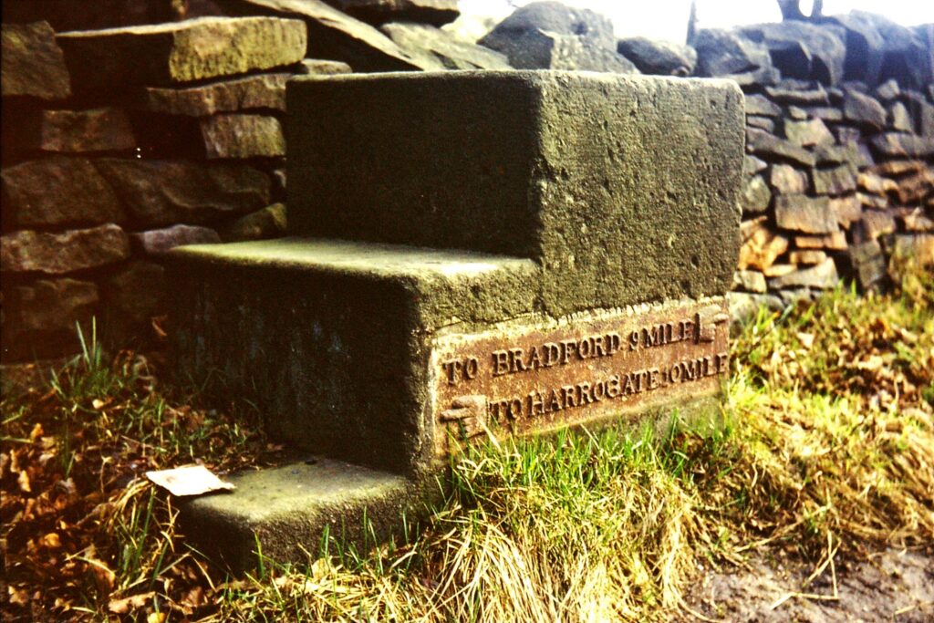
Occasionally, however, a different type is found, the horse mounting-block, or horsing-stone.  They combine the directions and mileages of the traditional milestone in a (usually) three-stepped stone to enable travellers to get on or off a horse easily. 

Quite why anyone should need to do this at a milestone is not clear.  It does, however, indicate that many travellers were on horse-back.

Mounting-block milestones survive in all three Yorkshire Ridings.

The only road entirely in the North Riding to have them was the York-Oswaldkirk turnpike.  In 1772 the trustees ordered that milestones be erected “in the form as follows: wood mile post 4½ feet in length; every third mile a horsing stone”.  Four of these are still in position.  Others can be seen on roads leading into the east Riding.

In the West Riding there are half-a-dozen on the road between Bradford and Harrogate.  These have (or in most cases had) a cast-iron plate giving destinations and distances.  One, at Pool, retains its plate – illustrated here.

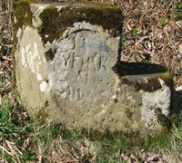
Another six survive on the original turnpike between Leeds and Otley, dating from the middle of the 18th century.  This road is now an unclassified road leading more directly and steeply from Otley and was replaced by the present A660 in 1842.  With destinations carved on the front and side, most are now badly weathered.

It is in the East Riding, however, that most can be found: in fact over 50 of the 108 milestones recorded by the Milestone Society are of the mounting-block type  – a feature unique in its frequency in the country.

The roads with mounting-block milestones include Beverley-Hornsea, Hull-Beverley, Hull-Hedon, Hull-South Cave, York-Beverley and York-Driffield.  Many have deteriorated from weathering, or suffered damage from grass-cutting, or traffic accidents, and many have lost their plates, but the County Council and Milestone Society members have been actively renovating them as time and resources permit. 

Click here for more information on the East Riding milestones.

Outside Yorkshire there is an interesting series of “horsing-stones” on the old Great North Road in Lincolnshire. The 4th edition of Paterson’s Roads of 1788 notes: ‘From Stilton to Grantham, at every Mile are Blocks, made of the famous Ketton Stone, with three Steps, which were placed there by a Mr. Boulter, for the easy mounting of his Horse, he being a very corpulent Man, and travelled that road every Week for many Years; each Stone engraved E.B. 1708.’ Milestone Society members have been researching these “Boulter stones” and their latest findings can be found on the Milestone Society website.

RWH / revised Jan 2022

Mounting-block milestones Read More »

Milestones on the York to Oswaldkirk Turnpike

Oswaldkirk is a village 20 miles north of York and four miles south of Helmsley in North Yorkshire. It is named after St Oswald (died 642), Anglo-Saxon king of Northumbria.

The turnpike was established by Act of Parliament in 1768 and followed the line of the present B1363. At Oswaldkirk the turnpike joined the present B1257, which with the A170 connected it with Helmsley. It thus provided a more direct connection to that area.

The milestones on this road are interesting, as every third stone is a so-called ‘horsing-stone’ – a tall block with steps to enable easy mounting of a horse. The minutes of the Turnpike Trust include the following details.

In 1772 ‘. . . milestones were to be erected … in the form as follows: wood mile post 4 feet in length; every third mile a horsing stone; … ‘. Later, in 1776 it was ordered ‘… that the mile posts be painted dark blue, with white letters and figures, old Roman capital letters and figures ‘. At a meeting at the (still there) White Bear in Stillington in 1789, it was ordered ‘. . . that the mile stones be repaired if necessary and that the letters or figures thereon be fresh painted’.

In 1814 it was ordered ‘that mileposts be erected at the end of each mile where the present stones are decayed and defaced, and that the first mile from York be measured from Bootham Bar, or such other place as the distance has commenced, and be so expressed upon the first mile post‘.

The Milestone Society has records of four surviving horsing-stones (or mounting-blocks) on this road. They are, from south to north:

At Wigginton, ¾ mile north of the A1237 York ring-road, on the west side of the road (and usually almost hidden in the grass), opposite the entrance to Villa Farm – three miles from York.

On the west side of the road north of Sutton-on-the-Forest, nearly opposite Low Inhams Farm, south of Moxby Lane, about half way between Sutton and Stillington – nine miles from York.

At Gilling East, just north of the cross-roads – 18 miles from York.

Between Oswaldkirk and Sproxton, about one mile south of Sproxton on the now B1257, on verge opposite the entrance to Golden Square Farm – 21 miles from York. Curiously, this appears to be beyond the remit of the Turnpike Trust, which ended where it met the Helmsley/Thirsk-Malton road at Oswaldkirk Bank Top. (Illustrated on right)

Those six, 12 and 15 miles from York have not been found.

Sources: Jennifer Perry: York-Oswaldkirk Turnpike Trust 1768-1881 (North Yorkshire County Record Office, 1977) and Milestone Society records.

See also the article on mounting-block milestones in the East Riding and elsewhere.

RWH / Jan 2019

Milestones on the York to Oswaldkirk Turnpike Read More »

Industrial boundary markers

With the onset of the Industrial Revolution, individual canals and railways were established by acts of Parliament. The companies formed were keen to mark the boundaries of the land they owned, leading to the erection of many boundary stones. The following are a few of those whose stones can still be found.

Canals

Leeds-Liverpool Canal: a stone remains at Oddy Lock, Armley, marked ‘L & L Co’.

Rochdale Canal: stones marked ‘R C Co’ can be found at Todmorden, Luddenden Foot and Mytholmroyd.  The stne pictured here is at Todmorden

Railways

Lancashire and Yorkshire Railway: a stone marked ‘L Y R’ stands beside a Calder & Hebble Navigation milestone at Kirklees Lock, facing onto the canal, with three other markers; other examples can be found at Luddenden Foot and Anchor Pit.

London and North West Railway: around 12 stones on the hillside in the vicinity of Pule Hill, Marsden, marked ‘L N W R’ indicate the boundary around ventilation shafts servicing the three-mile long tunnel under the Pennines. And at Beldon Brook near Lepton a handful of ‘L & N W Ry’ stones mark the company boundary around the foot of an impressive disused viaduct.

Waterworks

The late 19th century was a time of increasing municipal enterprise, including providing a growing population with clean drinking water. These works also needed boundary markers.

Ashton: numbered stones marked ‘ASDWW’ (for Ashton, Stalybridge and Dukinfield Water Works, set up in 1870) can be found around Chew and Dovestones Reservoirs above Greenfield in Saddleworth.  These may be estate boundary markers, but according to www.doveheritage.com they mark the lines of underground water pipes.

Bradford: around 20 stones marked ‘B W B’ can be found around the two Lanshaw Dams on Burley Moor near Ilkley.

Manchester: some ‘M C W W’ stones on Langsett Moor by Salter’s Brook – the catchment grounds for the reservoirs in Longdendale.  (Pictured right)

Oldham: ‘O C W W’ stones can be found at, among others, Blackstone Edge, Castleshaw, and the delightfully-named Broadhead Noddle in Saddleworth.

Source: an article by David Garside in the Milestone Society Newsletter, no 27, July 2014, pp 26-27.

RWH / Jan 2019

Industrial boundary markers Read More »

Refurbished milestones in the Holme Valley

Milestones around the Holme Valley have been having a clean-up. New Mill resident Rowan Denton was stuck in road works one day and noticed a very decrepit milestone out of his window. Someone ought to do something about that, he thought – and then, the lightbulb moment, why shouldn’t he be that someone?

A sculptor, joiner and mould-maker, and former film prop designer, Rowan, now with some funding from the Milestone Society, set about work in the blissfully hot summer of 2018, and his handiwork can be seen on all the roads leading into Holmfirth, and elsewhere. The Brayshaw & Booth stones erected by the West Riding County Council in the mid-1890s, have had their lettering beautifully restored, and Rowan has also painted some of the earlier turnpike stones on the Woodhead Road. These may date from 1768, or 1831 when part of the route of the road was revised – detail above.

Not content with milestones, Rowan has also restored some boundary stones (in This image has an empty alt attribute; its file name is HV-Rowan-HCWW-det-812x1024.jpg
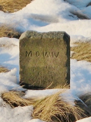
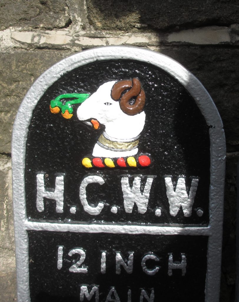
which the Holme Valley abounds), road name signs, and some plates from former water undertakings (Batley Corporation, Huddersfield Corporation and New Mill Urban District Council). The lamb that tops Huddersfield’s coat-of-arms looks especially attractive now – pictured right.

Pictured below are before and after photos of YW_GFSLH13 on the A635 at the top of the hill above New Mill.

Sadly (for us) Rowan has now left the district.

See also the Huddersfield Examiner, 19 July 2018, or watch a BBC news report at www.bbc.co.uk/news/av/uk-england-leeds-45334807/a-milestone-in-yorkshire-history-brought-back-to-life

RWH / Jan 2019

Refurbished milestones in the Holme Valley Read More »

Northern Spring Meeting, April 2016

34 members made it to Hebden for our 13th year of meetings: still not running out of topics.

This time we were entertained (again) by Dorothy and Brian Burrows, informed by Margaret Hill (eg about stiles, of which there are four kinds: step-through, climbing, combination and mechanical), and exhausted by David Garside (illustrating five ancient routes across the Pennines – he’s walked them all, and more).  And that was just before lunch.

Afterwards our guest speaker was Bill Froggatt, our Terry Keegan Award winner in 2014, now working for the Canal & River Trust on the Leeds-Liverpool Canal.  Its 127 miles and 91 locks were completed in 1816 – it is thus celebrating its bi-centenary this year.  He took us along the canal and its branches, illustrating mileposts and describing current restoration works.  It was a valuable perspective reminding us that we are but a part of a wider network appreciating our travel heritage.

Finally Christine Minto illustrated her own canal travels at home and abroad, with some excellent photographs.

JHS/August 2016

Northern Spring Meeting, April 2016 Read More »

Northern Spring Meeting, April 2018

27 intrepid souls braved the fog to make our annual meeting at Hebden in the Yorkshire Dales – beautiful whatever the weather.  Two members, from Kent and Perthshire, clocked up around 240 miles each to get there.

After the usual round of refreshments we were entertained again by Dorothy and Brian Burrows with their international miscellany of slides.

Our guest speaker had had to drop out a couple of days beforehand with a bout of flu, but David Garside ably stepped into the breach, taking us on a scenic tour of Yorkshire’s waterways and their waymarkers.

The afternoon opened with Lionel Scott describing the turnpike that failed, between Leeds and Wetherby, despite much interest from local property speculators – and concluded with a lightning overview of Scottish milestones from Christine Minto.

JHS/August 2018

Northern Spring Meeting, April 2018 Read More »

B6265: the road to nowhere

Anyone attending the Society’s Northern Spring Meetings from south of Hebden will probably have travelled on the B6265.  It starts outside the church at the top of the High Street in Skipton and heads northwards, through Grassington, to Hebden.  But how many travelling this way have noticed what it does next?  Read on to discover its peculiar 45-mile semi-circular route through some lovely countryside and interesting towns and cities to end up nowhere in particular.

It started life (in its modern incarnation) as the Skipton and Pateley Bridge Turnpike.  On the first milestone out of Skipton, however, a West Riding CC Brayshaw and Booth replacement of the 1890s, the road is described as the Skipton and Cracoe Road.  There are three of these – numbers 4 and 5 have not been found – after which one would not expect any more if the County Council thought the road stopped at Cracoe – though why they did not erect more will remain a mystery.

This image has an empty alt attribute; its file name is m_1-ESHD.jpg
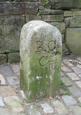
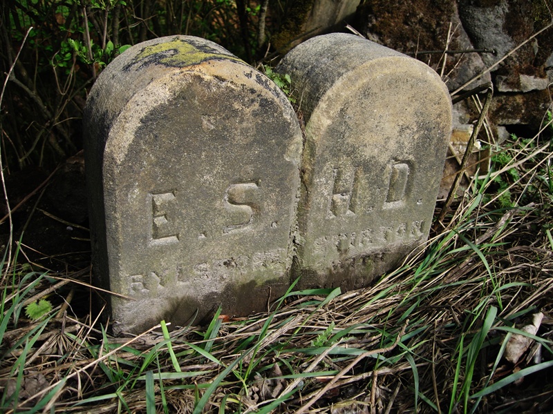
There are several boundary stones and guide-stoops on this first stretch. One stone, marking the boundary between Rylstone and Stirton with Thorlby, has the initials ESHD: the East Staincliffe Highway District erected a number of boundary stones in their area. 

The guide-stoops, undated but probably from the early 18th century, are all in a similar style, usually with a pointing finger.

This image has an empty alt attribute; its file name is m_2-Near-None-go-by-on-B6265-to-Cracoe-Threshfield-IMG_0081-2.jpg
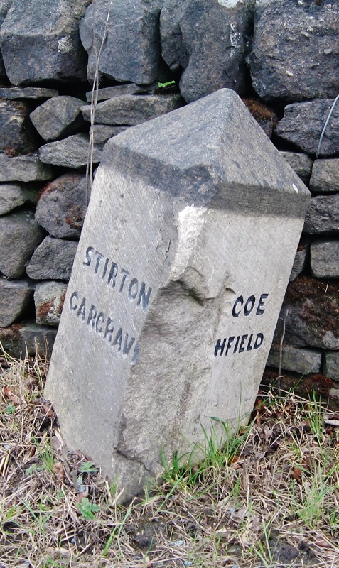
About 2 km beyond Cracoe a branch of the road forks off to the right to Linton, where it loses its B-road designation but continues to rejoin the main line just before the bridge at Grassington – the main section having carried on to Threshfield and around to Grassington.  There are three more guide-stoops in and around Linton.

There are also two earlier milestones, one marking seven miles from Skipton, just beyond the junction with the branch road to Linton, and one marking eight miles on the branch road in Linton itself.  It is presumed that they are the original turnpike milestones, although it is not until the 1894 edition that they are shown on the Ordnance Survey maps, and there is one in an identical style further up the dale beyond Threshfield and not on the actual turnpike.

And so to Hebden.  There are two bridges in Hebden, the old mediaeval one with a WR county bridge stone (pictured below, left), and the nineteenth-century one when the road was widened; this has a large 1827 carved on the parapet (pictured below, centre).  Just off the road is a rather weathered guide-stoop, and just as you enter the village an interesting old stone on the right bears a simple cross (pictured below, right).  This is actually a county bridge stone, denoting the point 300 feet from the bridge, where the parish responsibility for the road ended, and the county’s responsibility, for the bridge, began.  There is a similar stone at Skirfare Bridge higher up Wharfedale.

This image has an empty alt attribute; its file name is m_4-WR-Hebden-IMG_4720.jpgThis image has an empty alt attribute; its file name is m_5-1827-Hebden-IMG_4906.jpgThis image has an empty alt attribute; its file name is m_6-X-Hebden-IMG_4907.jpg

This image has an empty alt attribute; its file name is m_7-B6265-nr-Greenhow-IMG_6020.jpg
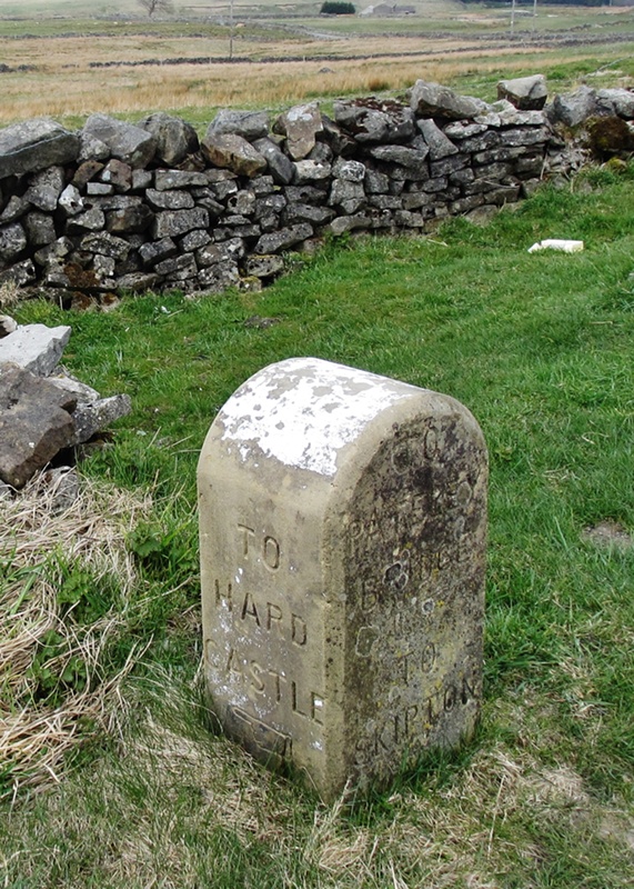
Beyond Hebden there are more guide-stoops, including, after Stump Cross Caverns, near Greenhow one in a different style with fingers pointing to Hardcastle, a now deserted but once bustling mining area (pictured left).  And it’s also worth a look at Toft Gate Lime Kiln, just beyond.

The road now enters Pateley Bridge, where it turns right and for a mile joins the B6165. While that heads for Knaresborough our B6265 turns off and meanders north-east, passing the entrance to Studley Royal and Fountains Abbey, to Ripon. This image has an empty alt attribute; its file name is Pateley-Bridge-Ingram-ms.jpg
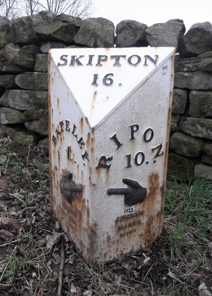
This, according to the 1854 Ordnance Survey map, is the province of the Ripon and Pateley Bridge Turnpike Trust.  Along the road is a series of milestones, some in need of some TLC, with iron plates cast by Ingram, ironfounders of Ripon, many more of whose milestones can be found on other roads from Ripon.  The last (or first from our direction) of these is in Pateley Bridge itself, on Ripon Road.  The one illustrated here is the first one encountered on the B6265 as it turns off the B6165.

Finally, beyond Ripon, the road heads east (on part of the Harrogate and Hewick Turnpike) and then back south towards Boroughbridge: now on the line of the former A1, the Great North Road before it was widened, earlier the Boroughbridge and Piercebridge Turnpike, and long before that the Roman Dere Street.

The milestones on the stretch from Ripon are of the Ingram variety, but on the old Great North Road there is a different style with directions to Piercebridge.  After Boroughbridge the Great North Road continues south to Wetherby while Dere Street, now the B6265, heads for York, part of the Boroughbridge and York Turnpike.  A few milestones survive, but after about ten miles the road finally comes to an end at its junction with the A59 near Green Hammerton.

Curiously there is a bit more of the B6265.  With the development of the A650/A629 Aire Valley Trunk Road, two old sections of the road have been re-designated as the B6265: one from Crosshills through Steeton into Keighley; the other from Keighley through Bingley to Cottingley.  Perhaps some misty-eyed planner once thought of joining them all up.

RWH / rev July 2020

B6265: the road to nowhere Read More »

Northern Spring Meeting, April 2017

27 people packed the Ibbotson Institute in Hebden for the Society’s Northern Spring Meeting: a familiar format of faces, cakes and slides.  Dorothy and Brian Burrows began the proceedings with the usual cornucopia of photographs of milestones and related objects from around the world.

David Garside then told us about the South Pennine Walk and Ride Festival, an annual event each September, for which he has been organising walks for a few years.  David’s Blackstone Edge walk covers 10-11 miles, including Roman (allegedly), packhorse and turnpike roads, mediaeval crosses and boundary stones.

June Scott gave a talk on historical distance measures.  Younger members of the audience (had there been any) would have marvelled at the peculiar units that were once everyday concepts: how much simpler (but less colourful) the metric system is.  Besides miles and their fractions older milestones often feature furlongs (originally the length of a furrow in mediaeval strip fields, later standardised at 220 yards – or 660 feet as the Americans would prefer to say).  A few may even show rods, poles or perches: some of us well remember these from primary school.  And, of course, the chain, one tenth of a furlong, the length of a cricket pitch, and ideal for measuring distances: June had an original one to show us.  The chain continued in use officially and on the railways until very recent times.  Finally some measures not found on milestones, shorter ones relating to the human body, and therefore not precisely defined: the cubit, for example, the distance from the elbow to the tip of the middle finger, about 18 inches (46 cm for our younger readers).

Concluding an interesting day, Keith Benton took us on a milestone tour from Anglesey (Ynys Môn) – the Holyhead Road – across to Northumbria, down through Derbyshire and back up through Cheshire to Cumbria.

RWH/July 2017

Northern Spring Meeting, April 2017 Read More »

Take-on and take-off stones

A take-on stone is a stone instructing a coachman to add an extra horse or horses to a conveyance in order to help pull the coach up a steep hill.  A take-off stone, conversely, is an instruction to unhitch the horse(s).  Such stones are few.

There are supposed to be three such stones surviving on Mortimer Road, on the moors above Bradfield, near Sheffield.  This road leads from Penistone to Grindleford in the Derbyshire Peak District.  Turnpiked from earlier packhorse routes, it was a financial failure, and its fascinating story is told in a book by Howard Smith (1993).  Its route is also traced on the Stocksbridge and District History Society website.

The take-off stone illustrated here is at the top of the hill just north of the Strines Inn, near the end of the West Riding stretch of the road.

Another such stone can be seen on a bridge near Haworth, with the words “Hang on”.  See the picture from Geograph here.

These stones are also known, at least to the Milestone Society, as “horse stones”, and the horses themselves are also called “cock horses”.  This term has applied to the children’s toy from as long ago as Tudor times, while the Banbury Cross nursery rhyme dates to the 18th century.  Its use in our context, however, is more recent: the OED has its earliest usage as comparatively recently as the late 19th century.  A quotation from The Field  of 25th July 1891 reads “With no further use for the cock horse, we cast him off at the top of the hill”.

RWH / Oct 2015, rev June 2024

Take-on and take-off stones Read More »

Beverley Sanctuary Stones

The concept of sanctuary, as a place where fugitives can be immune from arrest, dates back to the Bible (cf Numbers, 35), and was recognised in English law until abolished by James I in the 17th century.  It was a way to protect people from the vagaries of mob justice.  All churches could offer sanctuary within the actual church building, but there were over 20 churches in mediaeval England (including Beverley, Ripon and York in Yorkshire) which were able to provide a wider area of sanctuary.

In Beverley sanctuary began approximately two miles from the Minster.  If a pursuer caught his quarry within this area he had to pay a fine to the church authorities.  To denote the area sanctuary stones were set up on four of the main approaches to the town – these were tall columns with richly carved crosses – and there were other crosses nearer the Minster at points where fines increased.

Three of the outermost sanctuary crosses survive, though much defaced and without their tops, probably occasioned by post-Reformation zeal.

One is on the A164 road from Hessle and the Humber, just south of its intersection with the A1079.  This would have been the main route from Lincoln and the south.  On a square base, the column is 21/2 feet tall and 18 inches thick.  It can be clearly seen, having been rescued from vegetation during construction of the by-pass.

Moving clockwise the next is at Walkington on the route from Howden and the south-west.  Similar in size to the Hessle cross, this (illustrated) is on the left just past the traffic-lights coming from Beverley.

The third surviving stone is at Killingwoldgraves near Bishop Burton on the road to York (the A1174) just before the by-pass (again coming from Beverley).  Better preserved and taller than the other two, with some decorative features surviving, this is slightly away from the road and on a higher vantage point, perhaps to make it more visible (unless, of course, it has been moved).

The fourth, missing stone was on the road to Driffield and the north, the A164.  It is possible that it was lost during the construction of the now disused railway line to Market Weighton.

One sanctuary stone survives of the eight that originally surrounded St Wilfrid’s Monastery (founded 672 AD) in Ripon: Sharow Cross, now cared for by the National Trust, probably dates from the 13th century.  On Dishforth Road at Sharow, just off the A61 on the other side of the River Ure from Ripon itself, it is at SE 3235 7198.  Ripon Cathedral now stands where the original monastery was established.

Sources: Martyn Kirby: Sanctuary: Beverley – a town of refuge (updated ed, 200?); for Sharow Cross: https://historicengland.org.uk/listing/the-list/list-entry/1149835

RWH / rev August 2020

Beverley Sanctuary Stones Read More »