Wikipedia can also be also a mine of useful information. There are, for example, extensive articles on the Richmond and Lancaster Turnpike, and the Keighley and Kendal Turnpike.
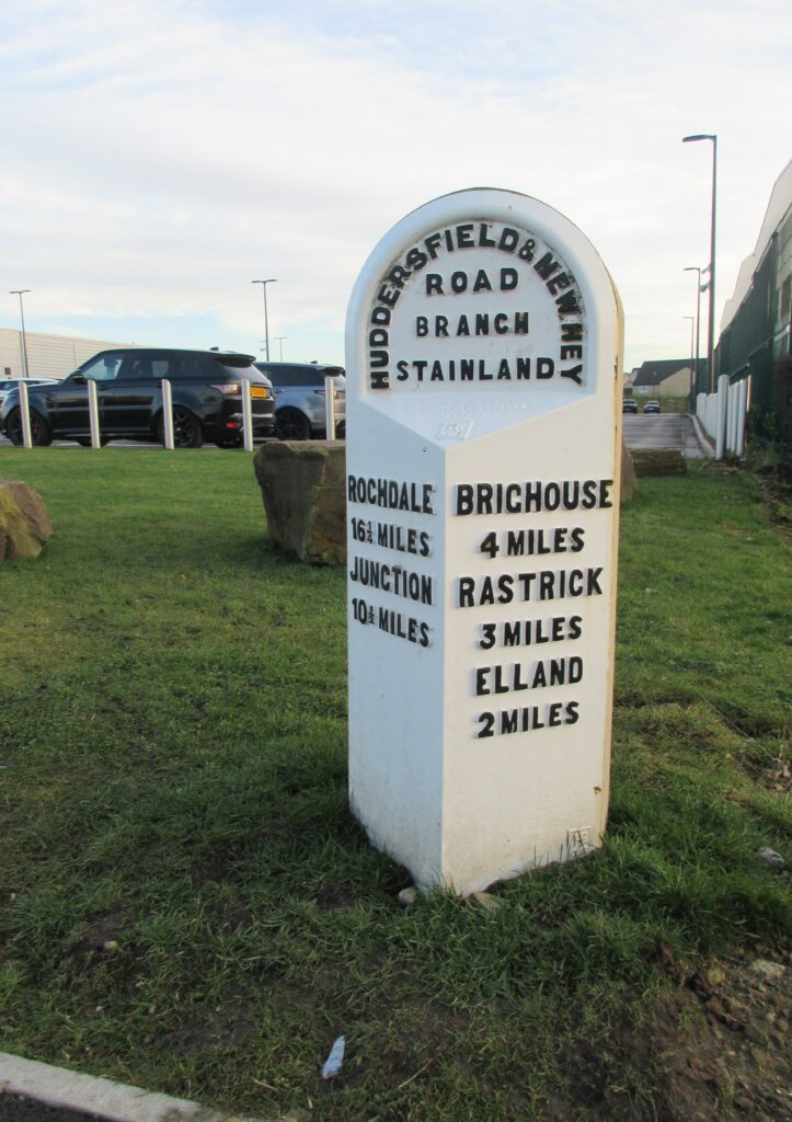
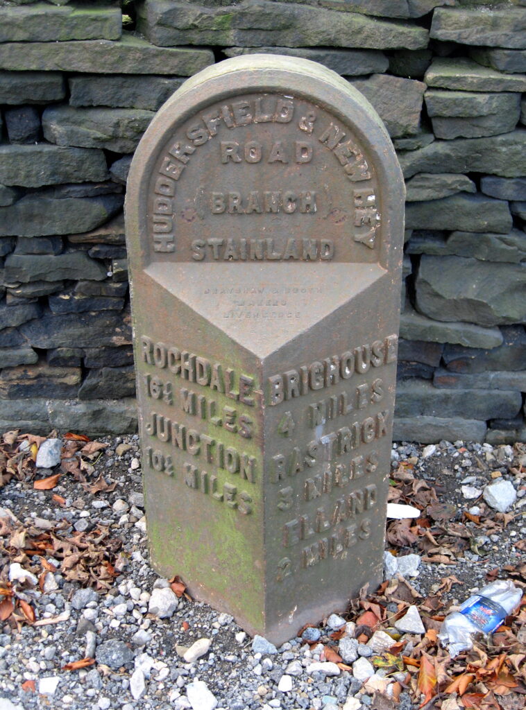
The A643 starts at Junction 23 of the M62, runs parallel with it for a few miles and then descends into Brighouse. When it was opened, in 1809, it was officially the Outlane and Rastrick Branch of the Huddersfield and New Hey Turnpike Trust. Three of the original four mileposts still stand on its 4½-mile length. The other was lost when the M62 was built.
Passing the Wappy Springs Inn, near Outlane, in late 2018, Jan Scrine noticed that the three miles from Rastrick post, and the wall against which it had stood, were gone – replaced by the entrance to a new industrial development. Enquiries were made to Kirklees Council, and it was found that the site’s planning applications had indicated the milepost was to be returned when the work was completed. It had, however, vanished.
[Although the post stood in what was originally Stainland in Calderdale a small part of this was transferred to Huddersfield in 1937 and is now in Kirklees.]
The replacement returned to (more or less) its original location
The story of the erection of over 600 mileposts by the new West Riding County Council in the 1890s is told elsewhere on these pages: cast at the foundry of Brayshaw & Booth at Liversedge , and erected by G & F Stead, stonemasons of Mirfield, over half survive, some lovingly preserved, others in a sorry state.
Local councillors were contacted and the developers agreed to fund a replica milepost, following the Milestone Society’s guidance notes. Stan Driver, the former Senior Conservation Officer at the Council, supplied extremely detailed information on size and composition. This was based on a similar milepost nearby, as well as his experience of replacing a series of Brayshaw & Booth mileposts in 2004. And the Senior Highways Design Engineer took a real interest in the project.
The Hargreaves Foundry in Halifax was tasked with the job. They prepared a wooden pattern and from this a mould made of Furan Resin Sand which came from China. This is a kind of self-hardening sand; after the coating is burned, the surface of the sand mould becomes extremely hard. A model was prepared and then the final cast was made and painted. The white coating was sprayed on using an AE52 paint system, a two pack polyurethane finish designed to have excellent durability and abrasion resistance – the technical instructions state that ‘Substrates must be thoroughly cleaned, dry and free from contaminants, corrosion and grease prior to coating’. The black lettering was AE53, ‘A high solids Polyurethane Compliant Finish for general purpose use with good salt spray resistance’, applied by roller. The casting bears the name of the foundry and the date 2019.
The cost of the casting project was £4160 including VAT; the developers are to be congratulated for their willingness to expend this amount to restore the milepost. Thanks are also due to the highways engineers, councillors and local Milestone Society members for their good-humoured persistence in following the matter to its happy conclusion.
A backing stone was obtained and in March 2021 the milepost was installed near to its original location by the Kirklees Highways team – a job well done! And the Brayshaw & Booth mould will also be available for any such future projects…
Mastiles Lane was a mediaeval track forming part of a road system connecting Fountains Abbey with its lands in the Dales and the Lake District.
It commenced at Kilnsey where many tracks converged on a monastic grange built in the twelfth century. This served all the Fountains Abbey estates in Upper Wharfedale, Littondale and upper Airedale. From here it crossed the open moorland of Kilnsey Moor and Mastiles, past Street Gate.
This name has also been given to the road itself, and is an indication that the route has actually been used in Roman times, and possibly even before that. Aerial photography and archaeology has revealed a Roman marching camp on it, just north of Low Stony Bank.
After Street Gate it crosses Malham Water, the short stretch of a stream that issues from the Tarn before disappearing underground to re-emerge not below the Cove as originally thought, but south of Malham village at a place known as Aire Head.
The name Mastiles Lane applies only to the stretch from Kilnsey to Malham, but the monastic route continued over to Stainforth and then north-west towards the Fountains Abbey lands in the Lake District. The origin of the name is not known, but it is not inconceivably related, albeit distantly, to the old Cumberland dialect word mastel, meaning a patch of an arable field never ploughed.
Wayside crosses were erected at prominent places along this stretch of the route: somewhere for a quick prayer to help you on your way, and to guide travellers over the somewhat featureless landscape.
These were generally square shafts inserted into hollowed sockets cut into a stone base. Five of these bases survive, though the crosses themselves have disappeared, re-used in later stone walls no doubt. A good example is near the point where Cow Gill crosses Mastiles Lane and the oddly named Smearbottoms Lane meets it (SD 9299 6548) – pictured right.
Two crosses that appear intact can be found in the vicinity of Malham: Nappa Cross and Weets Cross.
Nappa Cross is by Kirkby Fell, 3 km west of Malham village, just north of an old track to Settle (SD 8751 6416). Sadly, this is not entirely authentic: it has been moved, possibly from the junction of this path with the Settle track, and re-erected incongruously on the top of a dry-stone wall. And the shaft was replaced in 1965 according to the National Park.
Weets Cross is 2 km east of Malham, on Weets Top (SD 9252 6323). It is at a high point on a track from Mastiles Lane to the Fountains lands south of Malham, and a logical place for a wayside cross. Especially as it is at an important point of great antiquity where five townships meet: Bordley, Hetton, Calton, Hanlith and Malham.
Sources: article by David Garside in the Dalesman, August 2021; Geoffrey N Wright: Roads and trackways in the Yorkshire Dales (1985); websites: historicengland.org.uk, outofoblivion.org.uk, yorkshiredales.org.uk. Photos by David Garside and Milestone Society.
The Kirkburton Parish Council area was established as an Urban District in 1937, combining eight (originally nine) townships to the east of Huddersfield. Within the district are eleven villages: Farnley Tyas, Flockton, Grange Moor (officially in Whitley Upper township), Highburton (part of Kirkburton), Kirkburton itself, Kirkheaton, Lepton, Shelley, Shepley, Stocksmoor (part of Thurstonland township) and Thurstonland itself.
To celebrate the Queen’s 60th Jubilee in 2012 the Parish Council, with various other agencies, set up a project to create a series of ten walks centred on each community, and a series of leaflets with maps was produced. Each walk had the name of a former local personage for the title of the walk. For example, the Lepton walk features Anne Jessop (1850?-1941), daughter of Allen Jessop who established the first fireworks business in the village. The Kirkheaton walk remembers Elizabeth Drake, one of 17 girls who perished in a tragic fire at Atkinson’s Mill in Colne Bridge in 1818: they had been trapped upstairs.
And each walk had, at some point, a newly carved guide-stoop, modelled on the historic stoop at Farnley Moor, between Thurstonland and Farnley Tyas. As well as fingers pointing to the neighbouring villages each stoop also featured an item relating to the particular place. Thus the Grange Moor stoop shows the pit-head winding-gear at the local Shuttle Eye Colliery (closed in 1973).
The East Riding of Yorkshire is the smallest of the three Ridings and, unless you live there, a bit off the beaten track. It is, however, packed with interest
While people had travelled from place to place since prehistoric times, and it is possible that some of their tracks became, via later travellers in mediaeval times, the roads of today, it was the Romans who built the first roads. These were, of course, for military purposes and took no notice of the local population. One road started in Brough (Petuaria) – a continuation of the road from London via Lincoln (Ermine Street) to the Humber crossing. South of Market Weighton one branch of this road led via Warter to York and another through the Wolds to Malton. Another road extended eastward from York via Stamford Bridge across the central Wolds to the North Sea coast at Bridlington.
While the Roman roads formed the basis of Britain’s main road system (the King’s Highways) they were not necessarily the roads needed by the local population. Local journeys made by merchants with their packhorses or farmers moving livestock relied on drove roads, some of which had existed since prehistoric times. They were originally ‘green’ earth roads which avoided most settlements and were largely independent of other road systems. Many still remain on the Wolds, although most now have a narrow strip of tarmac for motor vehicles.
The turnpike movement took off in the 1720s, but the first in the East Riding was the Hull to Beverley road in 1744. Two other trusts were formed in the mid-1740s, for roads from Hull to Kirk Ella (which had become a location of choice for merchants of Hull wishing to live outside the city) and Hedon.
A second flurry of turnpike acts took place two decades later, when Beverley was the focus of roads to Leven (1761), Kexby Bridge (1764 – and thence to York the following year), Molescroft (1766 – a very short distance) and Hessle (1769). There was a plan to continue the Leven (White Cross) road to Bridlington in 1767 but this did not materialise.
Much later (1825) another road linked Hull with North Ferriby. Here (as the name implies) a ferry ran across the Humber to South Ferriby in Lincolnshire, probably from before the Norman conquest until the opening of the Humber Bridge in 1981.
Turnpikes required toll-houses, but following the demise of the turnpike system in the late 19th century sadly few have survived to the present day. As elsewhere they have succumbed from being too close to the carriageway. Toll-houses can still be found, however, at Cottingham, Leven (White Cross) and Woodmansey (near Beverley).
For more information see this very interesting East Riding Museums website on which much of the above is based. Other sources include W Albert: The turnpike road system in England 1663-1840 (Cambridge U P, 1972) and Wikipedia.
Helme is a small village in Meltham township, five miles southwest of Huddersfield. It was one of the earliest churches to be announced in the London Gazette, and unlike the others in the West Riding is described as an ecclesiastical district rather than a chapelry. Spelt Elm on the 6-inch Ordnance Survey map published in 1854, it was spelt Helme when the church was built, though Helme Lane is referred to as Elm Lane in the boundary description. The name appears to be unconnected with any trees that may have once grown here.
The Church is an attractive Victorian Gothic church with many original features, such as the Lord’s Prayer, Creed and Ten Commandments painted on the chancel walls, and the Beatitudes inscribed over the arches in the nave. The spire too is interesting, being the only wooden shingle spire in Yorkshire. It has no stained glass, thus enabling, so it is said, God’s handiwork in nature to be seen (and handy if the sermon is a bit dull).
Off Broadlands Road
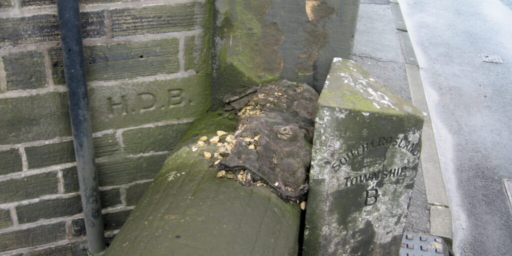
The boundary is defined in the London Gazette of 13th August 1858. Boundary stones are mentioned twice in the description, and they do not follow the later standard pattern, being unnumbered, and consisting only of the letters H D B (for Helme District Boundary). The first mentioned still exists, at the southern end of a public footpath leading from Helme Lane to Sunny Heys Road, just west of and roughly parallel to Broadlands Road (grid ref approx SE 0992 1110). It is very small.
At Bent Ley Mill
The second mention refers to stones (plural): one is not a free-standing stone but carved on the corner of Bent Ley former silk mill, on the main Huddersfield to Meltham road. Another boundary stone stands here, marking that between the South Crosland and Meltham Townships. Another, so far not checked, is presumably on the north-east corner of the same building.
There are several Thorpes in Yorkshire, but this is about one on the road between Triangle and Ripponden near Halifax. It’s not really a place, more just a house (now a bed & breakfast) and a mill (now apartments) – and, for less than a century, a church. Thorpe House was lived in by Frederick Rawson, a woollen manufacturer who owned the mill next-door and had the church built.
There were already old-established churches in Ripponden and Sowerby, both just over a mile away, and in 1848 a church, St Mary’s, was opened at nearby Cottonstones to serve the population of Mill Bank. This had been built with money left in the will of Ellen Hadwen, who died in 1842. She was a member of a family of cotton-spinners who owned various mills (not all surviving) at Kebroyd, just along the road from the Rawsons of Thorpe.
Despite all these, and perhaps out of local rivalry, Rawson decided to finance and build his own church, dedicated to St John the Divine, on land slightly nearer Triangle. He died in 1879 with the church not quite finished, but the work was continued by his widow Harriet and the church was consecrated the following year. It seated 300 people, and a Sunday School was built alongside for 200 children.
This being the Church of England all new church-building had to be authorised by the monarch, and announced in the London Gazette, the official record. The Thorpe St John Consolidated Chapelry (so-called because it was created out of more than one existing parish) was listed, with a detailed schedule of its boundaries, in the issue of 6th September 1881 – this despite being already built and functioning.
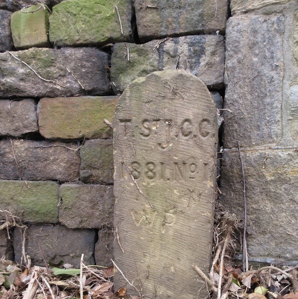
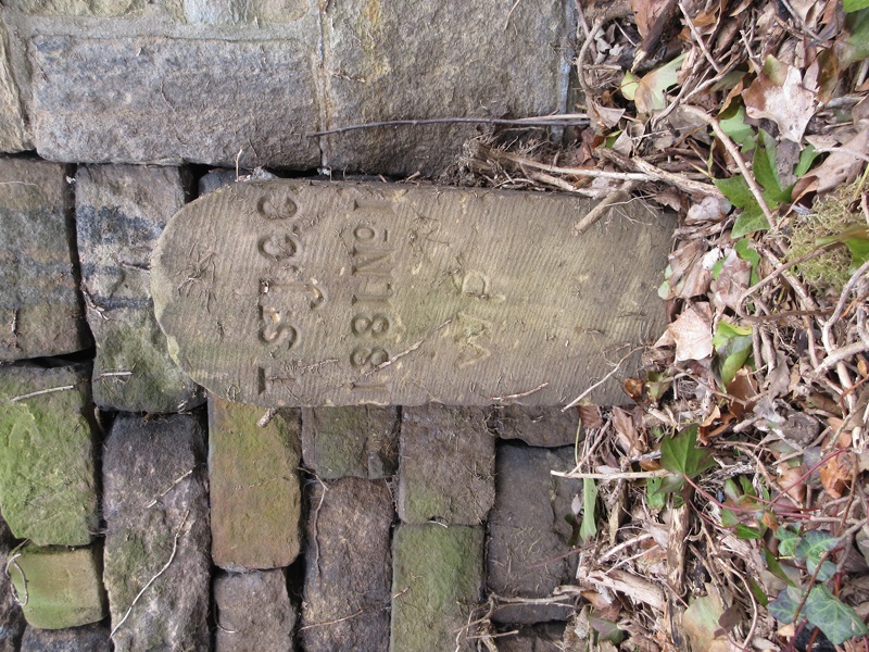
The boundaries of the Thorpe chapelry refer to two boundary stones, both of which still stand. From Kebroyd the boundary reaches “the eastern boundary of the buildings and premises called or known as Dean House and extending thence northward to and along the said wall or fence for a distance of eleven chains or thereabouts to a boundary-stone inscribed ‘T. St. J. C. C. 1881. No. 1’ and placed at the northern end of the same wall or fence on the southern side of Dean-lane”.
Skirting Mill Bank it then reaches a point “at or near to the junction of Birks-lane, Helm-lane, and Bowood-lane and extending thence north-eastward along the middle of the last-named lane for a distance of fifteen chains or thereabouts to a point opposite to a boundary-stone inscribed ‘T. St. J. C. C. 1881. No. 2,’ and placed on the south-eastern side of the said last-named lane at a distance of exactly four chains to the north of the junction of the same lane with Green-lane”.
The first stone, on Dean Lane, is just outside no 7, Saw Hill, and has recently (Autumn 2020) been cleared of the ivy which had hidden and presumably protected it. It is in very good condition. The second, on Bowood Lane, is about ½ mile north of Mill Bank, on the right-hand side of the road, built into a wall and now somewhat eroded.
The population of the area covered by the new church was not large, and it must have always struggled to have a viable congregation. In 1917 it suffered a disastrous fire and was rebuilt. In 1941 it became part of an amalgamated parish with the Cottonstones church, but was finally closed in 1968 and demolished in 1973.
Sources: Albert Senior: St John the Divine, Thorpe: souvenir of the Jubilee, Sept 20th 1930 (published 1930); London Gazette, 6 September 1881 (available online); Malcolm Bull’s Calderdale Companion (website)
Spur-stones have nothing to do with milestones or the Milestone Society, but they can cause confusion. So I thought it useful to mention them here. In some areas they are also known as jostle-stones.
A spur-stone, according to the Oxford Dictionary, is a stone fixed in the ground to support a post or to keep vehicles away from the footway, etc. More specifically, James Stevens Curl in A Dictionary of Architecture and Landscape Architecture (2 ed; OUP, 2006) defines it as an upright stone, often circular on plan, like a bollard, fixed in the road at an angle of a building or on each side of a vehicle-entrance to protect the corners.
The OED’s first traced use of the word is in the Gentleman’s Magazine of March 1848. In this a letter from a correspondent, B P of Maidstone, describes a mediaeval pillar or obelisk unearthed in Northampton in 1823, “part of it before having been above ground as a spur-stone. … The stone, when adopted for a spur-stone, seems to have been chiselled and trimmed at the top”. The use of the word here implies that it was well-known (at least among gentlemen), needing no further explanation.
In 1882 Richard Jefferies in Bevis: the story of a boy writes:
Bevis battered his flints till he was tired; then he took up the last and hurled it away in a rage with all his might. The flint whirled over and over and hummed along the ground till it struck a small sarsen or boulder by the wood-pile, put there as a spur-stone to force the careless carters to drive straight.
Jefferies came from Wiltshire, and Joseph Wright’s six-volume English Dialect Dictionary of 1898 describes it as a Wiltshire term, but this is presumably based on the Bevis quotation. He defines it as “a projecting stone … to keep the traffic from coming too close”.
The term “bollard” is used in a definition above, and this word can also be synonymous with spur-stone. Originally, in the 19th century, this was a nautical term to describe a “post on a ship or a quay for securing ropes to” (OED), possibly derived from “bole” – the stem or trunk of a tree, and by transference anything of a similar cylindrical shape. Its present use for an item found on pavements, traffic islands, etc, dates only from 1948.
So why is all this relevant to milestones? Because sometimes they can be confused with each other when located close together, when place-names have been erased, or when a milestone or similar waymarker is lost.
Two such stones are illustrated here. One, enjoining passers-by to stick no bills, is on Leeds Road in Huddersfield, not far from where a half-mile stone would have been – had there been one, which there wasn’t. The other, plain, is by a driveway in Wilshaw, Meltham. It stands almost exactly on the one-time boundary between Meltham and Netherthong.
As for jostle-stones the derivation of these is uncertain. Wright’s English Dialect Dictionary of 1902 has the term jostling-stone, but defined rather as “a block or stone on which a boy is bumped when the bounds of the parish are beaten”. He also has jostling-block: a block or stone used in mounting a horse. Both uses are from East Anglia.
Another term found is guard-stone. The OED defines these as “One of a row of stones placed to keep vehicles off the sidewalk”, which is a subtly different concept.