The village of Marsden, on the edge of the Pennine moors in West Yorkshire, has two attractive packhorse bridges: one in the centre, by the church; the other a noted beauty spot at Eastergate, a mile or so up the River Colne.
From the latter a track, the old packhorse road, climbs steeply uphill towards Buckstones on the present A640, and continued to Rochdale. Surviving documents show that this long, straggling path was much used by local carriers in the 18th century, and maintained by the Marsden-in-Huddersfield Township.
By the late 19th century, however, with the decline of the trade to Rochdale and the development of other forms of transport, the old packhorse route had become little used and had fallen into neglect. This suited, and played into the hands of, the Lord of the Manor, who resented the effect that passing traffic had on his grouse and was hoping to close the moors. His gamekeepers were instructed to deter members of the public and threaten “trespassers” with prosecution.
In 1906 the local Urban District Council, continuing the role of the township highways surveyor, carried out repairs, and matters came to a head. The Lord of the Manor, Sir Joseph Radcliffe, sued the Council claiming there was no right of way over the moor.
The case was held at Leeds in April 1908. The Council produced 33 elderly witnesses (the oldest was 92) who recalled using the track as children – ie before the important date of 1835. The judge concluded that the Lord of the Manor had failed to prove that there was no right of way, but also that the Council had exceeded their rights in the improvements they had carried out. Accordingly the costs of the case were split between the plaintiff and the defendants.
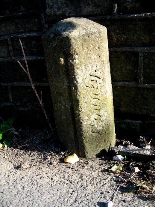
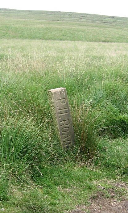
Among the improvements were 9 stones, carved with the words “P H ROAD”, set up at intervals along the track – a number of which still survive. These were described by the judge as a “technical trespass”, but did no harm, and might actually help walkers to stick to the path.
Canals in Yorkshire competed with the turnpikes in the era before the coming of the railways. Some, like the Aire and Calder Navigation and the Don Navigation, were built to make the river system navigable. Others, like the Calder & Hebble Navigation (the first part of which opened in 1770) and the Leeds & Liverpool Canal (opened in 1816) were constructed to provide transport routes into the towns and across the Pennines.
Barge operators charged their customers by the ton and by the mile, so the distance travelled was very important. Most inland canals and some river navigations had milestones. Whereas many roadside milestones have disappeared during road widening, the canals have been little affected and milestones can still be found on the Calder & Hebble Navigation and the Huddersfield Broad and Narrow Canals. The characteristic triangular cast iron mileposts on the Leeds & Liverpool Canal are replacements for earlier milestones, few of which remain today. Replica milestones can also be found on the Rochdale Canal.
A walk along the canal towpath provides a quiet respite from the bustle of traffic and a chance to find interesting milestones from the canal era.
Some examples of the county bridge and related stones in Yorkshire. For more information, click here.
A typical West Riding stone, over the River Skell near Fountains Abbey: a minor road and a minor bridge now, but possibly more important in mediaeval times. Grid Reference: SE 671 682
Another West Riding example, not a stone but a cast-iron bridge marker, over Hebden Beck, a tributary of the Wharfe at Hebden, between Grassington and Pateley Bridge. Grid Reference: SE 026 322
From the North Riding, this stone is in the centre of Greta Bridge, near Barnard Castle – a lovely old bridge, now bypassed by the A66. Grid Reference: NZ 086 132
This plaque is on a small bridge at Cowgill, over the River Dee, near Dent, in Dentdale (now in Cumbria). It reads: This bridg repered at the charg of th West Riding AD 1702. Grid Reference: SD 761 869
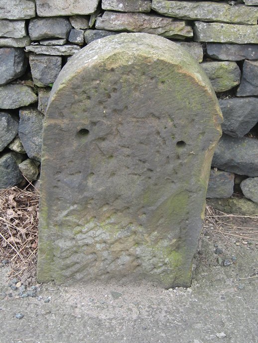
A most unusual example, one of a pair of stones each standing 300 feet from the River Holme, on the A6024 at Holmbridge, south-west of Holmfirth. Grid Reference: SE 121 068
A cross-type bridge marker on the Skirfare between Kilnsey and Kettlewell, just before it enters the Wharfe. Grid reference: SD 972 691
These photographs illustrate some features of different Brayshaw and Booth milestones in the old West Riding.
A well-looked after stone, one of many in the attractive village of Cawthorne, near Barnsley. Note the horizontal lettering. Grid Reference: SE National ID:
All the Brayshaw & Booth stones in the Saddleworth district, near Oldham, have recently been restored. Note the use of the old “mere” names (the four divisions of the township). Grid Reference: SE National ID:
Just outside Holmfirth, an interesting variant on the usual painting scheme. Here the letting is on a slant. Grid Reference: SE National ID:
An example of the wider flat stones used where the road was narrow, on the now perfectly wide enough road out of Elland towards Huddersfield. Also recently raised and restored. Grid Reference: SE National ID:
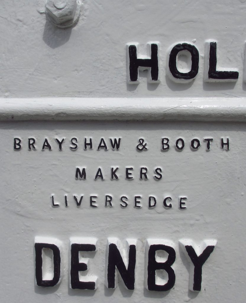
The Brayshaw and Booth name is clearly visible on this otherwise somewhat rusty stone at Lepton, near Huddersfield. Grid Reference: SE National ID:
A stone that has lost its iron plate, showing the Steads’ workmanship. This is on the A670 in Saddleworth, near the boundary with Mossley. Grid Reference: SE National ID:
In 1888 the Local Government Act established County Councils, among whose responsibilities were main roads. In this respect they replaced the highway boards (random collections of parishes) which had been taking over from the steadily collapsing turnpike trusts.
One of the largest county councils was the West Riding of Yorkshire, stretching from Sedbergh in the north-west, to Ripon and the River Ouse on the boundaries of York in the north-east, to Goole in the east, Bawtry in the south-east, Sheffield in the south, and up and occasionally over the other side of the Pennines in the west.
Providing services in such a huge area was always a logistical challenge – even ignoring the fact that large areas in the middle of the county (Bradford, Leeds, etc) were independent county boroughs outside the control of the County Council. Nevertheless, in 1892, less than four years after it was set up, the Council decided to set up milestones on all its main roads. No reason is given in the archives: maybe it was seen as a profile-raising exercise. Efforts to improve the image of local authorities are obviously nothing new.
Accordingly, on 12th October 1892 it was resolved to obtain tenders for the erection of “643 milestones, six inches thick, with iron plates, bolted, showing the name of the road, township and mileage to nearest towns”. The stone was to come from the Horsforth Quarries, and the milestones were to be 6 feet high, set two feet into the ground. The estimated cost would be £2-5-0d each.
The contract was awarded to G & F Stead, stonemasons in Mirfield (Gill Stead and his son Frank), who were now to erect 619 stones within 12 months of the date of the contract, 21st August 1893. They were paid in instalments, the final payment being made in October 1894, so presumably the work was finished on time. Not only on time, but also under budget: the Steads were paid £1,140, which works out at a mere £1-18-0d per stone.
The whole enterprise must have been an immense undertaking, bearing in mind the distances involved and the transport available (horse and cart).
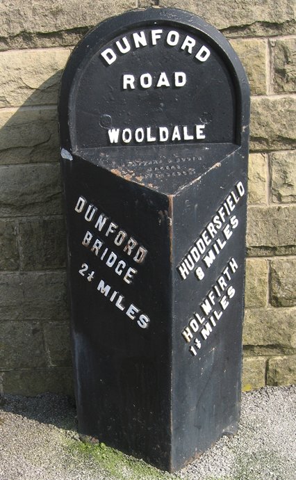
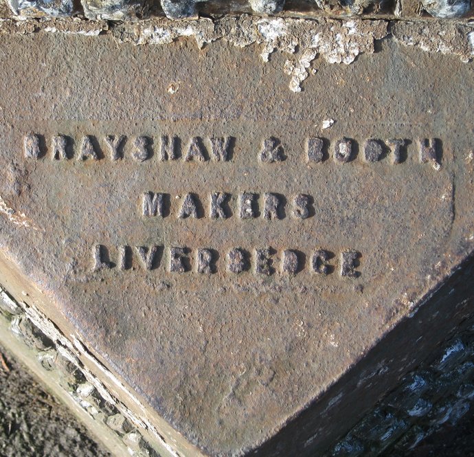
And it would also have been a mammoth task for the firm of Brayshaw and Booth, ironfounders of Liversedge, subcontracted to provide most of the iron plates required. Their name is displayed prominently on the huge number of their milestones that survive, but little else is known about them: they are listed in trade directories between 1889 and 1917. Another ironfounder supplying plates was William Towler of Leeds: see separate article.
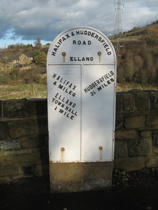
Over 60 roads have, or had, the new WRCC milestones. While most will have replaced the existing turnpike trusts milestones, some are on non-turnpiked roads, but some turnpikes were not included. The major road from Halifax to Todmorden, for example, still retains its original pointing-finger stones.
About 350 stones survive, though a few are broken or have lost their plates (and sadly accidents continue to happen). Some have been restored by Milestone Society members and other agencies such as parish councils. Rotherham Council has been particularly good at looking after its stones, and Kirklees restored some of theirs some years ago.
Almost all have the protruding triangular iron plates, but eleven stones are wider and flat: these are found where the original road was excessively narrow (as it still is on the oriiginal bridge over the River Holme on Hollowgate in Holmfirth – pictured right); others are in Sherburn-in-Elmet, Elland, Uppermill and Denby Dale.
Another peculiarity is the lettering: sometimes it is horizontal; sometimes at an angle. There is no pattern to this, though each road is to a standard design. It is unrelated to the amount of lettering (of which there is sometimes a great deal – up to 160 characters). Nowadays, as roads and pavements have got resurfaced, some of the information has disappeared under the asphalt.
Traces of blue on a B&B at Elland
A final puzzle is the colour of the original plates. The contract stipulated that they should be painted blue, and traces of blue paint have been found on some stones (see photo, left). Perhaps the colour was changed to the almost ubiquitous – and much clearer – white early on, or perhaps it was blue only on the rim, but no reference to this has been traced. One milestone in Mirfield was painted blue and gold in 2012 to celebrate the Diamond Jubilee; see the article on the Kirklees restoration project for details.
Adapted from an article by Christine Minto, with additions by Stephen Skellern, in On the Ground (no 5, 2008, pp 16-18). A longer article by Christine was published in the Saddleworth Historical Society Bulletin, 2015, vol 45, no 1, pp 1-17; it is available online.
 The village of Marsden, on the edge of the Pennine moors in West Yorkshire, has two attractive packhorse bridges: one in the centre, by the church; the other a noted beauty spot at Eastergate, a mile or so up the River Colne.
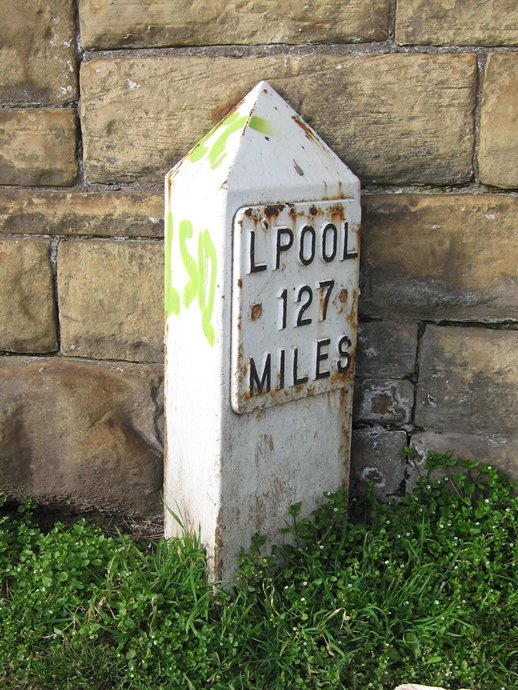
 Some, like the Aire and Calder Navigation and the Don Navigation, were built to make the river system navigable. Others, like the Calder & Hebble Navigation (the first part of which opened in 1770) and the Leeds & Liverpool Canal (opened in 1816) were constructed to provide transport routes into the towns and across the Pennines.